The Manayunk Canal almost became the Manayunk Expressway. Here’s how it was saved.
Today, the Manayunk Canal marks its bicentennial as an integral part of Philadelphia’s industrial history — part of a 32-dam system that made the shallow, rocky Schuylkill navigable.
By the late ‘60s, the debate had been raging for years over what to do with the Manayunk Canal, which lowered its last coal barge downriver nearly half a century earlier and had stagnated ever since, a sorry, smelly, scum-encrusted two-mile stretch of yuck.
There was a camp, desperate for relief from the already traffic-clogged artery of I-76, that cast an opportunistic eye toward the channel. It could be covered and paved, they argued, making way for a roaring Manayunk Expressway that would whisk cars into the heart of Center City along the Schuylkill’s eastern banks.
Then — because not much has changed in Philadelphia in half a century — there were those who wanted to talk parking. Fill in the debris-laden canal, they said: Create acres of abundant parking.
Today, the Manayunk Canal marks its bicentennial as an integral part of Philadelphia’s industrial history — part of a 32-dam system that made the shallow, rocky Schuylkill navigable — and later the backdrop for a boutique- and bar-lined retail district and recreation area. The Fairmount Water Works is commemorating the day the first toll (6¼ cents) was collected, March 15, 1819, with an exhibition of archival photographs and hand-painted maps from 1827, tours of the locks, and other events.
It’s also a pivotal moment for another reason: The Philadelphia Water Department is poised to move forward on a project to restore water flow to the canal for the first time in half a century (improving water quality at the Queens Lane intake just downstream). The city Parks and Recreation Department announced it has grant funding to restore the canal’s lower locks, chambers used to adjust water levels so that boats can travel up and downriver. And Manayunk boosters have a $600,000 grant to improve connections to the businesses that line the canal — including more access points to the towpath and facade improvements that will make it feel less like a back alley and more like a destination.
The story of how the canal went from trash heap to tourist destination pivots on one of Philadelphia’s great human bullhorns of the 20th century, Harry Olson.
Olson, now 94, recalled attending a community meeting in 1969 — and being shocked to learn of the canal’s tenuous state.
“The general consensus was fill it in and make it a bypass for Main Street. I said, ‘Well, jeez.' ” He believes that was the turning point. “If they hadn’t had the meeting, the canal wouldn’t be there.”
Over the years, Olson, a longtime Manayunk resident and a flight-test mechanic by trade, was a relentless advocate of numerous causes, some fated to materialize, others to evaporate (among the former, the Philadelphia-to-Valley Forge bike trail, which he began lobbying for with the Sierra Club in 1973; among the latter, a whitewater canoe training course on the Schuylkill, and a historical site at Levering’s Ford, where George Washington and his troops crossed on their way from a camp in East Falls).
Olson’s Depression-era childhood, on a dairy farm in Gladwyne, instilled in him a love of nature, a self-reliant streak, deep-seeded frugality, and determination.
He brought all of that to bear on the canal. Where others saw a ditch filled with tires and trash, Olson saw something more: the centerpiece of a bicycle trail linking Center City and Valley Forge and a tourist draw like the canal that had anchored the development of New Hope in Bucks County into a lively tourist town. It seemed like a fantasy at the time, given the state of the neighborhood, a gloomy mix of janitorial stores, warehouses, and beer distributors.

Wissahickon
Valley Park
Flat Rock dam
PHILADELPHIA
Schuylkill
River Trail
Lock 68
76
Manayunk Development Corp. and the city will work with businesses to improve canal access.
At the canal inlet, a new dam intake will be built to restore flow to the canal, and the existing lock structures will be preserved.
Manayunk
Canal
LOWER MERION
Lock
69/70
N
Arch bridge
MILES
The city will rehabilitate and stabilize the lower locks.
0
1/4
Cynwyd Heritage Trail
Staff Graphic

Flat Rock dam
Lock 68
Schuylkill River Trail
1
PHILADELPHIA
Manayunk
Canal
Lock
69/70
2
LOWER
MERION
Arch bridge
N
3
MILES
Cynwyd Heritage Trail
76
0
1/4
At the canal inlet, a new dam intake will be built to restore flow to the canal, and the existing lock structures will be preserved.
1
Manayunk Development Corp. and the city will work with businesses to improve canal access.
2
The city will rehabilitate and stabilize the lower locks.
3
Staff Graphic

In 1969, he rallied a group of Boy Scouts, and they started mucking out the canal themselves. (Olson was never much one for outsourcing. For years, once the city took over the work, he continued to gripe to the press that it was overpaying for it.)
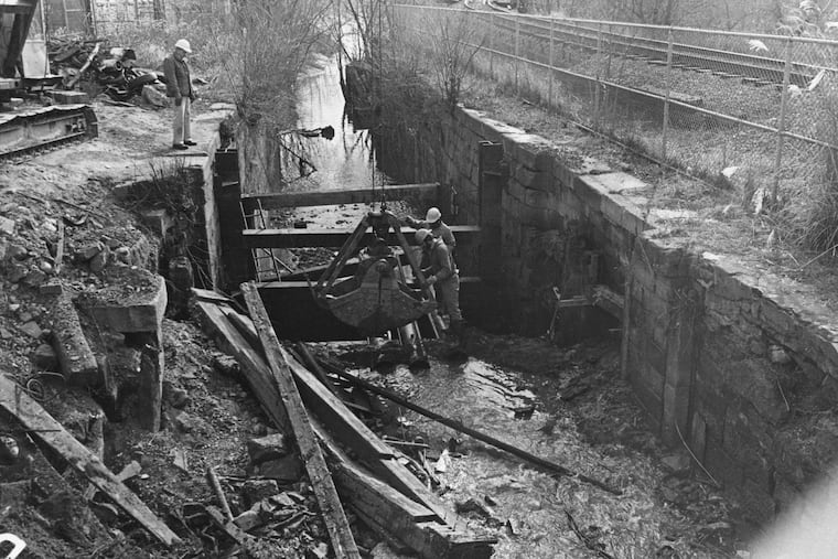
Eventually, Olson’s vision caught on. With city and federal support, work began in 1977 to stabilize the canal and lay down a bike path alongside it, by filling in the canal on the opposite side from the original towpath. There were dreams of boating, of barge rides drawn by horses pacing along the canal-side path. “Please consider gondolas,” Mayor Frank Rizzo said at the groundbreaking.
For historians, the work of saving that canal is valuable. It’s the only section of the 108-mile Schuylkill navigation — the nation’s largest coal-carrying waterway in its time — to be preserved from end to end. It’s also the only intact section of canal within Philadelphia city limits.
Recently, Sandy Sorlien, a photographer for the Water Works who has been documenting the navigation system, picked her way down the banks across from the Fairmount Water Works, trying to locate the remnants of the Fairmount Canal. “I have a picture of them filling it in, but it’s really the saddest picture I ever saw,” she said. She and Stuart Wells, a historic preservationist who wrote his graduate thesis on the canals, pored over old photographs, a copy of an 1824 Thomas Birch painting, and an 1841 schematic to get their bearings, then wandered the rocky shore at low tide, looking for telltale fragments of ironwork.
“We’re grasping at straws,” Sorlien said, after pointing out an interesting drill mark. “It just shows how important it was that they saved the Manayunk Canal.”
But farther down along the water, two rows of timbers sticking out of the water remain, visible only at low tide. Wells was convinced they were remnants of the outer tail wall, marking the lower end of the canal.
Still, “saved” is a flexible term, acknowledged Kay Sykora, who was the founding director of the Manayunk Development Corp. and who recently completed a strategic plan for the nonprofit Roxborough Manayunk Conservancy.
“Obviously, the city was never particularly interested in maintaining the canal," she said. "It was something they ended up acquiring from the state in the 1970s.” It became sealed up with silt, fed by stormwater runoff. “You basically have a lake that doesn’t move,” she said. “With that, you get stagnant water and a lot of algae.”
The work on the canal will be the most extensive in decades, cleaning the water, providing boating access (though no one is talking gondolas), stabilizing the locks, and, Sykora hopes, providing historical markers to raise awareness of the outsize importance of this little canal.
“The history [of the Schuylkill] is interesting, because it is the story of this country,” she said. “During the period of industrialization, it provided jobs for a lot of the immigrants coming over, and Manayunk is an early example of that experience.”
