Stolen, vandalized, buried, lost: Mason-Dixon Line markers are getting surveyed to be saved
When Mason and Dixon sailed out of Philadelphia in 1768, they left about 300 markers to show the boundary between the two colonies. Many of those remaining are in danger of being forgotten.
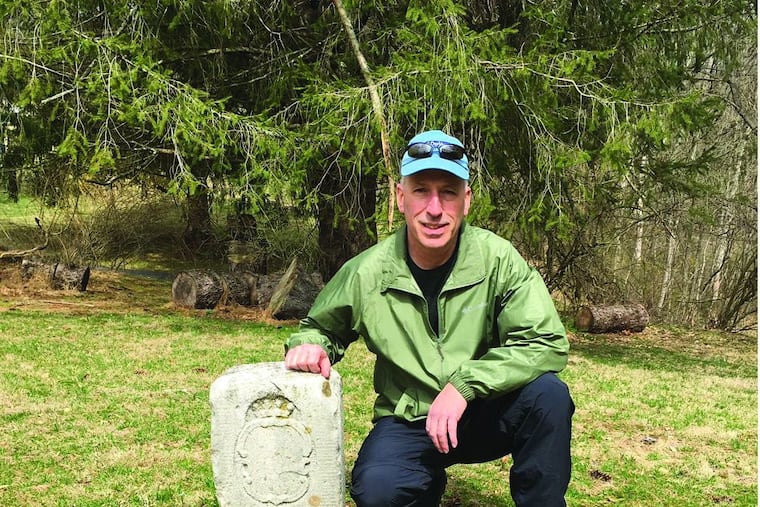
EMMITSBURG, MD. — It stands sunken, chipped, and tarnished, at the point where Pennsylvania drifts to a halt and Maryland begins. It is drenched in time, a sentinel guarding America’s past, canted and jockeyed by the frosts of 253 winters.
The limestone marker was placed here in 1767 by workmen under the direction of Charles Mason and Jeremiah Dixon, two English scientists who were nearing completion of a five-year survey that drew a line between two American colonies. It is designated No. 85 because it’s 85 miles from the beginning of the east-west Mason-Dixon Line near Newark, Del.
Today, only about one foot of No. 85′s original five feet is above ground. The family shields are faded but discernible. It is shaded by a towering Norway spruce that might have been a seedling or sapling when Mason and Dixon passed by.
Eric Gladhill, a professional surveyor who grew up within a thousand feet of the line, eyes the stone appreciatively.
“The line was an amazing achievement, some say comparable to the landing on the moon,” he says. “It was the most daring surveying task ever undertaken, and it established a criteria for all future long-distance surveys.”
When Mason and Dixon sailed out of Philadelphia in 1768, they left about 300 markers, some of them temporary, to delineate the boundary between the two colonies. Some are missing, and many of those remaining are in danger of being lost and forgotten.
Now, Gladhill and others are working to make sure that doesn’t happen. He is leading a volunteer group of 20 surveyors from Pennsylvania and Maryland who are documenting the location and condition of the stones as the first step in getting them placed on the National Register of Historic Places. Once the stones get historic status, organizations could then get grants to maintain and preserve them.
In the course of two and a half centuries, man and nature have not been kind to these palpable monuments to American history. They have been eroded, shot at, stolen, vandalized, hit by snow plows and tractors, farmed over, buried by road construction, inundated by dam construction, incorporated into walls by builders, removed and pressed into service as doorstops, steps and fireplace mantles, and spray-painted bright yellow by Maryland wildlife officials to keep hunters from straying across the state line.
The milestones were quarried and carved in England. Most of them bear a P on one side and an M on the other, but at every fifth mile along the line, the markers, like No. 85, are called crown stones because they are engraved with the Penn family coat of arms on one side and the Calvert family coat of arms on the other. They originally weighed 600 pounds.
» READ MORE: Freedom on the line: Mason-Dixon's enduring legacy
The official journal of the Mason-Dixon expedition shows they passed No. 85 on Aug. 30, 1765, and it notes they crossed French Creek, which today still bubbles along, brimming with trout like feathering scarves. As the survey party skirted the homes of settlers, some of them learned for the first time whether they were residents of Maryland or Pennsylvania.
The current survey was initiated by Richard Ortt, director of the Maryland Department of Geological Survey, who is overseeing the project. So far, 165 monuments have been surveyed. Five are missing, and about 25 have yet to be located. To qualify for the designation, the project must be completed by August 2021.
The lesser-known part of the line, which now separates Maryland and Delaware, was placed on the National Register in 1975 through the efforts of the Delaware Historic Preservation Office. The boundary begins at Fenwick Island, Del., and runs west for 35 miles, then north for 87 miles to the point where the west line begins. This section is significant only as a state boundary, however, because both states allowed slave ownership.
The still-unprotected 233-mile east-west line achieved lasting fame on March 1, 1780, when Pennsylvania abolished slavery, and it became the boundary not just between Pennsylvania and Maryland, but between freedom and slavery.
Pennsylvania was an important thoroughfare on the Underground Railroad. In all, several thousand formerly enslaved people found their freedom following an imagined railroad across an imaginary line.
Harriet Tubman made dozens of journeys across the line guiding freedom seekers. She herself escaped, and some biographers record her reaction on her initial journey:
“I had crossed the line of which I had so long been dreaming. I was free. I looked at my hands to see if I was the same person. There was such a glory over everything. The sun came through like gold through the trees and over the fields, and I felt like I was in heaven.”
After the Civil War, slavery was abolished, but the Mason-Dixon Line still separated North and South, and up and down the line, racial hatred that had been seeded two and a half centuries earlier continued to be watered every day.
South of the line, Jim Crow laws enforced rigid segregation in airports, restaurants, schools, hotels, sporting events, theaters, and other venues. During World War II, Black and white soldiers on troop trains bound for training camps in the South would be separated at or near the line.
Even today, the line is embedded in the national psyche as a powerful symbol.
The east-west line also signifies the survey’s scientific achievement, successful because Mason and Dixon were not traditional land surveyors but astronomers with a record of accomplishments.
Their challenge was to venture more than 200 miles into the wilderness. No one had ever attempted such a thing. They had to take into account the curvature of the Earth. To stay on course, they had to keep changing direction ever so slightly. Every 11 miles, they would stop, read the stars, and adjust 50 to a hundred feet or so to get back on course.
Battling accidents, snow-covered mountains, dense forests, flooded rivers, wild animals, and nitpicking bureaucrats, Mason and Dixon used instruments that were crude by today’s standards to plot a boundary that is still accepted by the U.S. Geodetic Survey.
But when Mason and Dixon left America in 1768, their work was soon forgotten, and in all likelihood they never heard or saw the term “Mason-Dixon Line.” Indeed, the report issued on the survey in 1768 didn’t even mention their names.
Edwin Danson, a British surveyor-historian, believes their achievement has never been acknowledged properly.
“Neither Charles Mason nor Jeremiah Dixon was awarded with the Fellowship of the Royal Society they so justly deserved. But perhaps, after all, their best and lasting memorial are the marker stones of the Mason-Dixon Line itself.”
William Ecenbarger is the author of “Walkin’ the Line,” a travel-history about the Mason-Dixon Line.