Storm Jonas was one for the record books
A historic winter storm, packing hurricane-force gusts, inciting record tides at the Shore, creating blizzard-like conditions and impacting 20 percent of the nation's population, heaped up to 28 inches of snow - and a colossal cleanup operation - upon the Philadelphia region.
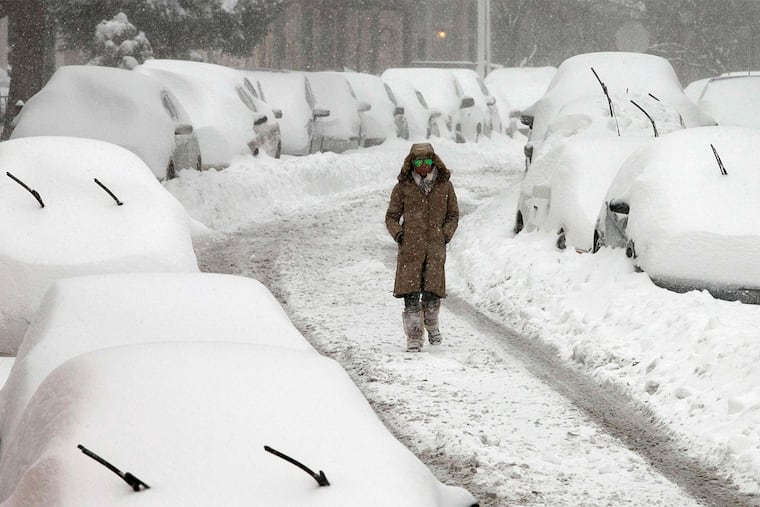
A historic winter storm, packing hurricane-force gusts, inciting record tides at the Shore, creating blizzard-like conditions and impacting 20 percent of the nation's population, heaped up to 28 inches of snow - and a colossal cleanup operation - upon the Philadelphia region.
The storm finally wound down, with only light snow expected the rest of Saturday night, but not before an official 22.4 inches was measured at Philadelphia International Airport, close to the average for an entire winter and the fourth-biggest snowfall in 132 years of record-keeping.
The Great Melt should get underway Sunday, with sunshine and temperatures expected to crest above freezing.
But Jan. 23, 2016, will be remembered as one of the wildest days in the region's weather history. Lehigh Valley Airport seemed to top the region with 31.9 inches as of 2 a.m.
Beach-erasing waves pounded Shore towns in Jersey, where officials said the flooding rivaled that of Sandy in 2012. As if to match the snow, as much as a foot of water sloshing from the engorged back bays coursed through the streets of popular resort towns such as Ocean City.
More than 40,000 power outages were reported in South Jersey, mostly in areas close to the coast, where winds gusted past 60 m.p.h. - likely the result of a so-called gravity wave.
The Atlantic City Fire Department used an Army truck to evacuate residents of an apartment building on one flooded street.
Saturday night, officials still were trying to extricate some of the 500 vehicles that had been stranded on the Pennsylvania Turnpike for almost 24 hours in deepening snow. Among them: The Temple University gymnastics team.
Road crews throughout the region should be getting cooperation from the weather not only Sunday but all week. No snow is in the forecast, nor is any flooding, although showers are possible Tuesday.
About now, road crews and residents with buried driveways and sidewalks will take all the help they can get from nature.
Philadelphia Emergency Management Director Samantha Phillips pleaded for patience. "That's a lot of snow in 24 hours," she said; actually, it's a record for Jan. 23. "And the Streets Department has all of its crews working," she said.
Throughout the day Saturday, blowing and drifting snow hampered road crews. "This is a difficult storm," said Pennsylvania Department of Transportation spokesman Gene Blaum.
While the blizzard-like conditions were unmistakable, weather service meteorologist Dean Iovino said it would take a few days to determine if the storm met blizzard criteria - three consecutive hours of 35 m.p.h. winds and/or quarter-mile visibility.
The snow inched into the region around 7 p.m. Friday as a powerful storm moved toward the coast, where it mutated into a strong nor'easter.
At least one storm-related death was reported, that of an 88-year-old man who was shoveling snow in Lower Providence, Montgomery County.
Calls to area dispatchers across the region showed no reports of major crimes.
Yet for all that, the region did benefit from some good fortune, thanks to the timing of the storm - the brunt coming on a Saturday - and the fact that it came with a perhaps unprecedented amount of notice.
The forecasts themselves did as much to shut down the region as the snow. In fact, had it not snowed, it might still have felt like a snow day, with just about every event canceled, malls and businesses closed, and transportation options scarce.
Some Center City streets hadn't been this empty since Pope Francis came to town in late September.
The oft-maligned computer models had foreseen the possibility of a megastorm a solid week before. "That's quite a feat," said Dan Petersen, meteorologist at the national Weather Prediction Center, who in his 25 years has witnessed a storm bust or two.
Inland, the winds evidently had a plus side: blowing snow, most of it of the drier variety, off trees. Only scattered power outages were reported, and as of 6:45 p.m. only 140 customers in the five-county region were without power, said Peco spokeswoman Liz Williamson, adding that beefed-up crews were able to respond quickly.
The storm, and winds, were having a profound effect on transportation, but officials had acted preemptively, based on the forecasts.
Montgomery County spokesman John Corcoran said more than 300 stranded-vehicle calls came in from Friday night into Saturday afternoon, largely because of wind blowing snow all over the highways. "They can't tell which areas have been plowed. The snow covers it right back up, so they don't know what they are driving toward," Corcoran said.
Philadelphia International Airport canceled all Saturday flights, and 155 departures and 133 arrivals scheduled for Sunday, according to the website Flightaware. The airport plans to resume operations gradually, and passengers should check with their carriers, a spokeswoman said Saturday night.
SEPTA suspended all services except the Market-Frankford and Broad Street lines, with the aim of resuming operations Sunday. PATCO posted a special snow schedule for the weekend.
NJ Transit suspended all operations, and Amtrak operated on a modified schedule.
States of emergency were in effect in Pennsylvania, New Jersey, and Delaware, along with snow emergencies in Philadelphia and surrounding towns that banned parking on snow emergency routes.
The National Weather Service reported that tides at Lewes, Del., were 8.98 feet above normal, short of the record 9.2 feet set in the Ash Wednesday storm of 1962. Hurricane-force wind gusts - 75 m.p.h. - were reported at the Delaware shore.
The extreme winds, extending from the Maryland Eastern Shore to South Jersey, probably resulted from a "gravity wave," Petersen said.
During storms, the atmosphere behaves like a stormy ocean, with rising and falling waves. Snow forms when warm air rises over cold air - and when air is rapidly rising, it creates a wave that can extend for a few hundred miles, affecting a narrow corridor. The air away from the wave crest has to sink, aided by gravity, and that generates dangerous winds.
The global models can't forecast things such as gravity waves, and "thundersnow" - a winter-storm thunderstorm, such as the one that dumped 8 inches of snow in three hours on Long Island Saturday - meteorologists say.
They didn't nail everything with this storm, but overall, the models run by the Americans, Europeans, and Canadians might be high-fiving each other.
At least one person didn't get the memo. Justin Goromaru, 27 of South Philadelphia, was trying to catch a train to Harrisburg Saturday morning at 30th Street Station.
"I actually didn't even know there was a snowstorm coming," he said.
Goromaru said he did manage to catch a cab. Not surprisingly, it got stuck in the snow.
He then had to get out and walk seven blocks to the subway.
twood@phillynews.com610-313-8210@woodt15
Staff writers Joseph A. Gambardello, Jacqueline L. Urgo, Jan Hefler, Patricia Madej, Andy Maykuth, Tricia L. Nadolny, and Suzette Parmley contributed to this article.
Snowfall Totals Selected cities Regional snowfall map, A15.
StartText
City Amount*
Glengary, W. Va. 40.0"
Gainesboro, Va. 38.0"
N. Potomac, Md. 36.5"
Malvern 28.2"
Collegeville 26.0"
New York City 25.1"
Baltimore 25.0"
Washington 22.5"
Philadelphia 20.8"
Mount Holly 19.5"
SOURCE: National Weather Service
*As of 9:00 p.m.
EndText
MORE STORM COVERAGE
StartText
Questions remain as SEPTA plans a Sunday restart of service. A14.
A good day for the computer models. A16.
Trouble from Gulf Coast to Maine. A17.
Weathering the storm across the region. B1.
After the Academy Ball cancels, what about the food? B1.
EndText