Bolaris: Wicked nor'easter to strike entire East Coast
This forecast is shaping up to be one of very high concern for our northern and western suburbs, where many of our neighbors are slowly recovering from last week's ice storm. This time it looks like heavy wet snow will punish those very same suburbs with more power outages likely.
Looking at the latest guidance, a good chunk of the nation east of the Mississippi looks to suffer extensive to massive power outages as a severe ice storm will strike first the South and Southeast before spreading northeast into interior sections of the Mid-Atlantic, with towns like Raleigh-Durham, N.C., seeing three-quarters of an inch of severe icing.
For us the good news is that, as it stands now, freezing rain should not be extensive. Instead, heavy wet snow will pile up on trees and power lines causing additional outages. Some locations could receive 12 inches or possibly more.
This storm will wreak havoc from the Panhandle of Florida to Portland, Maine.
The setup
Northern jet stream energy will phase with southern jet stream energy to induce rapid intensification of a storm moving northeast from the Gulf of Mexico to near the Carolina coastline by Wednesday night.
Right now, it appears bombogenesis (rapid intensification of a storm) will take place just off the Delaware and Virginia coasts. The combination of an arctic high pressing down from the north and east and ridging (mountain of high pressure) over the western Atlantic should not allow the storm to escape east out to sea.
Plus, the now re-energized trough (valley) in the East will take on a negative tilt meaning the storm will be a slow mover with at least 18 hours of some type of precipitation starting Wednesday night.
Timing: Wednesday night-Thursday
Snow will overspread the region from south to north starting between 8 and 10 p.m.
CITY
10 p.m.-5 a.m., accumulating snow 4-6 inches.
5-7 a.m., should see a changeover to sleet and then all rain in the city.
7 a.m.-3 p.m., windswept rain, occasionally heavy.
3-8 p.m., rain may mix with sleet and change back to snow before ending, some additional accumulation possible, but should not be significant.
Overnight: Clearing and windy.
NEW JERSEY
All areas west of Route 295 and New Jersey Turnpike will experience the same as Philadelphia with 4-6 inches of snow, then a changeover, with rain ending briefly as some snow Thursday night.
East of Route 295, accumulations of 2-4 inches then a change to rain by 4-5 a.m.
Southeastern New Jersey and coastal sections will see snow and sleet quickly changing to rain with little accumulations.
Tidal flooding will be a concern during the morning tide cycle and the early evening. Moderate tidal flooding possible. This would take place on Thursday.
EASTERN CHESTER, EASTERN MONTGOMERY AND LOWER BUCKS COUNTIES
Snow arrives after 8 p.m., heavy at times overnight with 6-8 inches possible by Thursday morning commute.
6-9 a.m., changeover to sleet and then rain.
10 a.m.-8 p.m., windy with rain heavy at times, might mix with sleet and wet snow at times, before changing back to all snow and ending after 8 p.m. Some additional accumulation possible.
BIGGEST IMPACT ZONE: NORTHWEST CHESTER, BERKS COUNTY AND LEHIGH VALLEY
Mainly all heavy, wet snow with some mixing of sleet (not anticipating freezing rain to be a problem).
12 inches likely and possibly more if storm remains on its current projection. Winds, power outages, perhaps widespread, likely to re-occur, due to the heavy wet snow snapping trees and power lines in combination with the strong wind.
WESTERN CHESTER, WESTERN MONTGOMERY AND UPPER BUCKS COUNTIES
Snow arrives after 8 p.m. Wednesday night.
Heavy at times through Thursday morning rush, with 8-10 inches before a possible changeover.
Changeover time would be close to noon, if the storm remains on its current projection.
Mixing, then going back to all snow later in the afternoon. Additional snow accumulation likely.
In summary
Nor'easter arrives Wednesday night after 8 p.m. and continues through the day on Thursday.
The biggest impact will be seen north and west of Philadelphia.
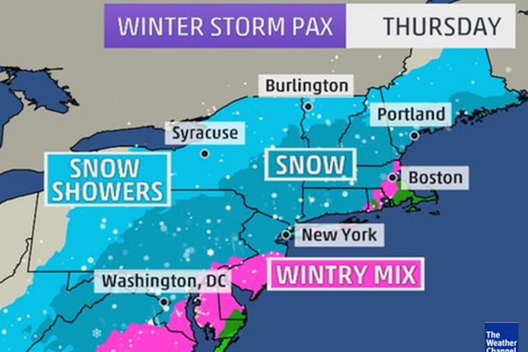
NYC: snow arrives 10 p.m.-midnight Wednesday. 4-8 inches, then to sleet and rain, and briefly back to snow late Thursday.
Boston: Thursday, 6-9 inches of snow, then mix to rain and back to snow.
Lower Hudson Valley, through central Connecticut and into interior Massachusetts, Vermont, and Maine, 14-20 inches likely.
Washington, D.C.: Snow Wednesday night, mixing with and changing to all rain early Thursday morning. 3-5 in the city. 6 plus north and west.
This is an extremely complicated storm and I'm sure adjustments will need to be made as the window closes.
Keep in mind that for a storm of this nature the margin of error is still on the high side. But as of 5:15 p.m. Monday the 10th of February this is how I see it.
John Bolaris