South Jersey remains in Irene's path
Irene has begun lashing the Carolinas with rain and big waves, and hurricane warnings are in effect up to the mouth of New York Harbor.
Irene has begun lashing the Carolinas with rain and big waves, and hurricane warnings are in effect up to the mouth of New York Harbor.
Irene, packing 100 m.p.h. winds as of this afternoon, poses the biggest threat to Northeast states since Hurricane Gloria took a similar path in 1985 and killed 11 people after hitting Long Island.
"Irene is expected to remain a large tropical cyclone and has the potential to produce damaging winds, storm surge flooding and extremely heavy rains anywhere from eastern North Carolina northward through New England," said the National Weather Service.
Mandatory evacuations have begun in New Jersey for all of Cape May County; Ocean County's Long Beach Island; and coastal parts of Atlantic County, including Atlantic City.
All day, cars were streaming onto the Garden State Parkway and Atlantic City Expressway.
The warning, which means that heavy rain and hurricane-force winds of 75 m.p.h. or more are expected, applies not just to all of South Jersey and Delaware, but to Philadelphia and Delaware County as well, according to the National Weather Service.
The warning was later extended into Chesapeake Bay to Drum Point, Md., just north of the mouth of the Potomac River.
A less dire but still scary tropical storm warning is in effect for Chester, Montgomery, Bucks and Mercer Counties, according to the National Weather Service.
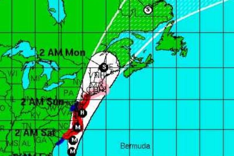
Irene is forecast to move near or over the mid-Atlantic coast Saturday night, according to a 5 p.m. advisory from the National Hurricance Center. Maximum sustained winds are presently 100 mph and some weakening is expected after Irene passes over the North Carolina coast Saturday, but it is expected to remain a hurricane as it moves up the coast on Sunday.
Storm surges are expected to raise water levels by as much as four to eight feet above ground level in New Jersey. Rainfall could measure from six to 10 inches with widespread flooding.
As of early this afternoon, Irene was projected to go over the North Carolina coast as a Category 2 storm and pass by the Jersey Shore as a Category 1 hurricane, before heading inland over New York's Long Island.
The latest tracking model projects it will be just off Atlantic City at 8 a.m. Sunday, with 86 m.p.h. winds and 104 m.p.h. gusts.
"The general forecast track is that it may go a little east or west, but it's still bringing it up over southern New Jersey," Dean Iovine, a meteorologist with the National Weather Service's Mount Holly office, said earlier.
"It's a very big storm, so it will make some difference where it tracks, but it's going to have an impact on everyone," he said. "It's just a matter of time."
Some uncertainty and hope linger, however.
The official map of the storm's potential path shows a chance the center could still wind up well off the Jersey coast - or even as far west as Lancaster County. Over the last several days, the predicted track has shifted from 75 miles off the coast to almost right up the Jersey Turnpike, then just off the coast.
It's been decades since New Jersey has seen anything like Irene, Iovine said. The last comparable storm was Hurricane Donna, a Category 3 storm when it swiped the coast in 1960.
Irene is predicted to be a less intense Category 1 when it arrives.
Nevertheless, a National Weather Service briefing as of late last night was grim. It warned of "record coastal flooding" if the storm surges at its maximum during high tide - as is anticipated.
"There is a high risk of this being a very damaging, life-threatening event," the briefing warned.
It also ominously stated: "Catastrophic inland flooding from very heavy rainfall is now a distinct possibility."
Another update is expected at 5 p.m.
The warnings have reached most of the public. The Home Depot in Cherry Hill was out of backup battery-operated sump pumps as of last night, as was the Lowe's in Maple Shade.
But at the Shore, surfers rode the waves and hoped for higher crests.
Atlantic City has an estimated homeless population of over 1,000 people and authorities believed many would try to ride out the storm on the streets.
At the Atlantic City rescue mission Friday, case workers were preparing to hit the pavement to tell the homeless about shelters available on the mainland.
"A large percentage won't go," said Lou Gasparini, a case worker. "I've been fighting them all day. They think they're better off out there."
The storm surge from the hurricane is predicted at four to seven feet along the New Jersey and Delaware Atlantic Coasts, but will also flood inland creeks and rivers.
If the hurricane tracks further west, heavy rainfall will threaten the Schuylkill and Lehigh River basins, increasing the chance of significant flooding.