Rain, wind cause Jersey Shore flooding
ATLANTIC CITY - Even though Hurricane Joaquin appeared to be heading well out to sea, the Jersey Shore remains caught in what the National Weather Service called a "squeeze play" between weather systems conspiring to generate heavy rain, powerful winds, coastal flooding and potentially significant beach erosion.
ATLANTIC CITY - Even though Hurricane Joaquin appeared to be heading well out to sea, the Jersey Shore remains caught in what the National Weather Service called a "squeeze play" between weather systems conspiring to generate heavy rain, powerful winds, coastal flooding and potentially significant beach erosion.
Steady winds of better than 30 m.p.h. with gusts up to 57 m.p.h. are expected to persist into Sunday afternoon, inciting beach-eating waves, indirectly tied to Joaquin whose approach is days away.
"It ain't over," said Walter Drag, the marine specialist at the National Weather Service in Mount Holly.
The weather service has extended its coastal flood warning through 6 p.m. Sunday. "Moderate to major flooding" is possible at high tide Saturday, which occurs at 12:24 p.m. at Atlantic City, said Joe Miketta, the warning coordination meteorologist.
Fresh computer-model data push the track of Joaquin well out to sea, and any effects on the Jersey coast would be "indirect," Drag said. Forecast rain totals for Saturday and Sunday were under 0.25 inches.
"We're definitely urging mariners to stay off and stay out of the water," said Chief Petty Officer Nick Ameen of the U.S. Coast Guard public affairs office in Atlantic City.
The barrier islands are likely to lose substantial chunks of beach over the next two days, but the full extent of erosion won't be known until sometime next week. Beach loss could affect the coastline heading into the winter.
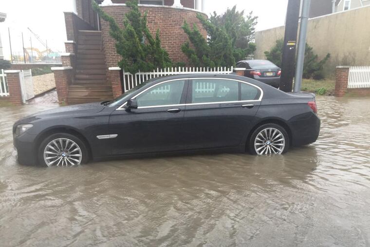
Friday's weather produced localized flooding typical with nor'easters and not the dangerous situation they had feared, officials said. Still, the storm exposed vulnerable areas not rebuilt post-Superstorm Sandy, such as the inlet end of Atlantic City - made famous in 2012 for photos of the broken boardwalk.
Water poured into streets that dead end at the inlet (facing Brigantine), where the old Boardwalk is being demolished ahead of an 18-month construction timeline.
On Dewey Place, a tiny side street with nothing between the street's end and the ocean, water ran unabated into the street at high tide. Alicia Casada, 55, her two grandchildren, 4 and 1, and companion Domingo Cancel, 70, hunkered down but seemed relieved to learn Joaquin would not be their next problem.
"There's nothing protecting us," Casada said. "It's kind of scary."
This week's storm "reminds us of the significant event we just endured," said Fire Lt. Tim Daley, deputy emergency management coordinator in Brigantine. "But people are much better prepared."
Brigantine was expecting flooding to be contained to the back bays, but the town had pushed sand to the street entrances and along the beach to prevent ocean flooding and to try to minimize erosion.
As strong winds and rain whipped through Cape May on Friday, there were some who were enjoying the weather: surfers. "It's a pretty heavy nor'easter," Dan King, 39, of Delmont, Cumberland County, said as he and fellow surfers warmed up in a pickup. "It's perfect surfing conditions."
Jennifer Pagano, owner of the Periwinkle Inn on Beach Avenue in Cape May, said she was grateful the city had built up a sand mound Thursday in front of her inn, where there is no sea wall.
The hotel, which is usually booked until it closes for the season in mid-October, was about 70 percent full Friday because of cancellations due to the forecast.
As a precaution, the Department of Environmental Protection closed state waters to shellfish harvesting effective at sunset due to expected heavy rainfall. Bivalves in these beds such as clams, oysters and mussels are filter feeders that can accumulate harmful bacteria carried into waterways from the land by storm water runoff.
Gov. Christie said Friday that New Jersey appeared to have dodged "a bullet" with Hurricane Joaquin tracking eastward into the Atlantic Ocean.
"Let's keep our fingers crossed," he said at a news conference in Sea Isle City. "We know what happens when we don't get lucky."
On a lighter note, asked if he had found the now-famous fleece he sported during Hurricane Sandy, Christie said it was at home in his closet.
"Given Joaquin wasn't coming ashore, I didn't think it appropriate to break out the heavy artillery of the fleece," Christie said. Instead, he wore one given to him by the Camden County Police Metro Division - one of the 27 he received post-Sandy.
609-823-0453 @amysrosenberg
Inquirer staff writers Rita Giordano and Anthony R. Wood contributed to this article.