Brooklawn Circle floods have locals wondering if new remediation efforts will hold water
The flood-prone Brooklawn Circle has been inundated and closed to traffic repeatedly, inconveniencing thousands of drivers and many local residents and businesses.
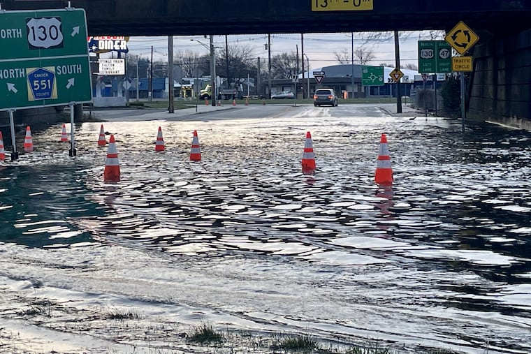
People who live, work, or drive along Route 130 near the border of Camden and Gloucester Counties know all about flooding at the Brooklawn Circle.
“They call it ‘the Brooklawn car wash,’” said Joseph Verchio, whose produce and deli business overlooks the western of the two connected circles that share a single name.
Laid out nearly a century ago on both sides of a low-lying railroad underpass and located close to the Delaware River between the Big Timber and Little Timber Creeks, the Brooklawn Circle is historically flood-prone.
But the periodic high water and road closures around the borough of 1,800 have in recent months lasted longer and become more disruptive, said local officials, businesspeople, and residents.
Some attribute the increase to the construction that began last May on a $54 million state Department of Transportation project to replace the Route 130 bridge across Big Timber Creek just south of the western circle and to improve drainage infrastructure in the circle. The bridge was built in 1928 during construction of the circle itself.
“It seemed that after they started construction, the water became more of a problem instead of a nuisance, and the water has been staying in the circle longer,” Verchio said.
Some of the most dramatic and sustained flooding occurred in conjunction with a record 10.6-foot Delaware River high tide on Jan. 10.
According to data collected by the National Weather Service, about 15.32 inches of rain fell from December through February in Philadelphia. That’s a little more than 5 inches over the normal average the last 30 years. and is equivalent to all of the rain that typically falls in April.
“From the third week of December until the Super Bowl [Feb. 11], we had the most brutal stretch of flooding I’ve ever seen,” Verchio said. “When that circle closes and stays closed, it hurts us.”
DOT spokesperson Stephen Schapiro said workers installed a subterranean pump Feb. 12 to help move the water through the drainage system. He said it was “incorrect” to connect the construction on the Route 130 bridge with the frequency of flooding events in and around the circle.
“The project has not reduced the capacity of the existing drainage system,” Schapiro said, adding that workers have added “many new drainage structures around the circle.”
No shortcuts
“We get 30,000 to 40,000 cars a day through Brooklawn, and when the circles get shut down, we get outsiders who all think they know a shortcut through our town, speeding all over the place,” Brooklawn police chief Shamus Ellis said.
When flooding forces the closure of the circle, Brooklawn has an established detour to allow east-west local traffic to cross the active freight railroad line, Ellis said. “It used to be we could go years without having to open the emergency crossing.”
The Brooklawn Circle was closed about 45 times in 2023 and 15 times so far this year, according to the DOT. No flooding or closures were reported between Feb. 13 — the day after NJDOT installed the pump — and the first week in March.
Flooding on the circle on March 15 lingered in the western circle and beneath the overpass until Sunday.
Overall, the water levels in the tidal Delaware have been rising steadily for more than a century. The Inquirer reported last year that as measured in Philadelphia, sea level has risen on average 3.1 millimeters (0.12 inches) annually over the last 120 years.
But that has accelerated to about 4.7 millimeters (0.18 inches) in the last 30 years — a rate that suggests an additional foot of sea level rise by the end of the century.
A community of online watchdogs
Two Facebook pages, as well as the websites 42Freeway.com and brooklawncircle.com, keep tabs on the flooding and have become a virtual community of circle watchdogs, stakeholders, and advocates for improvements.
Mark Matthews, who runs 42Freeway and devotes a section of his site to a “digest” of Brooklawn Circle flooding news, has 9,400 followers for his ”Is the Brooklawn Circle Flooded?” page on Facebook. A private group has established the Brooklawn NJ Circle Updates!!! page. It has 300 followers — and an image of the legendary Loch Ness sea monster on its landing page.
“When the circle is closed, it really cripples traffic not only on 130 and 47, but also I-295,” Matthews said.
Aaron Belz, a software engineer, set up brooklawncircle.com in October 2022 due to his “overflowing of frustrations” about flooding.
In the 18 months since, 116,000 users have used its real-time updates, he said.
“A Brooklawn Circle closing seems [remote] unless you’re in the middle of it,” he said. “I wanted to help people with their day-to-day commuting, and right away I started getting positive feedback.”
More projects in the pipeline
Another DOT project — to replace the bridge that carries Route 47 across the Big Timber Creek and connects it to the eastern circle — is set to begin this spring. That $47 million project also will include drainage improvements, a DOT spokesperson said. That work will include the site, intersection and roadways of the former Gateway Diner, a Westville landmark.
» READ MORE: South Jersey’s revered Gateway Diner closes to make way for a bridge construction project
Separately, two other federally funded studies of how best to ameliorate flooding at several locations near the circle are under way.
“We’re looking at flooding issues related to the Big Timber Creek in Brooklawn, Gloucester City, Bellmawr, Westville, and Mount Ephraim,” said Scott Schreiber, executive director of the Camden County Municipal Utilities Authority.
He said the two-phase, $750,000 effort aims to help the five towns improve stormwater management infrastructure to address current problems.
Camden County engineer Jim Winckowski said another study involving the Delaware Valley Regional Planning Commission focuses on flood-prone locations along County Route 551 north of the circle in Brooklawn as well as in Gloucester City.
A small-town grain of salt
A Camden County borough that promotes itself as “a little town with a BIG personality,” Brooklawn occupies just over half a square mile on both sides of Route 511, with Route 130 as its eastern boundary.
Most of Brooklawn’s distinctive detached, twin, and triplex housing date from the early 20th century, when the federal government built homes for workers at the New York Shipbuilding Co. in Camden. The circle that bears Brooklawn’s name is perhaps the sole survivor among the dozen or so traditional circles that once dotted the Camden County landscape.
Regardless of the projects and the plans, some local residents said they’re skeptical about whether the flooding issue can be resolved.
“Lately It’s been worse, especially under the overpass, and I don’t think it can get any better,” said Janette Multanski, who has lived on the borough’s west side for more than 30 years and works as a crossing guard. “There’s nothing much they can really do about it.”
Mirac Sahin, who manages the Falcon Diner, was more upbeat.
“I’ve seen the plans,” he said. “Hopefully it will work and the flooding will stop.”
