Dorian has company. Tropics getting crowded as new storms form. More coming?
Three named storms. including Hurricane Dorian, are spinning in the Atlantic Basin, with two more possible.
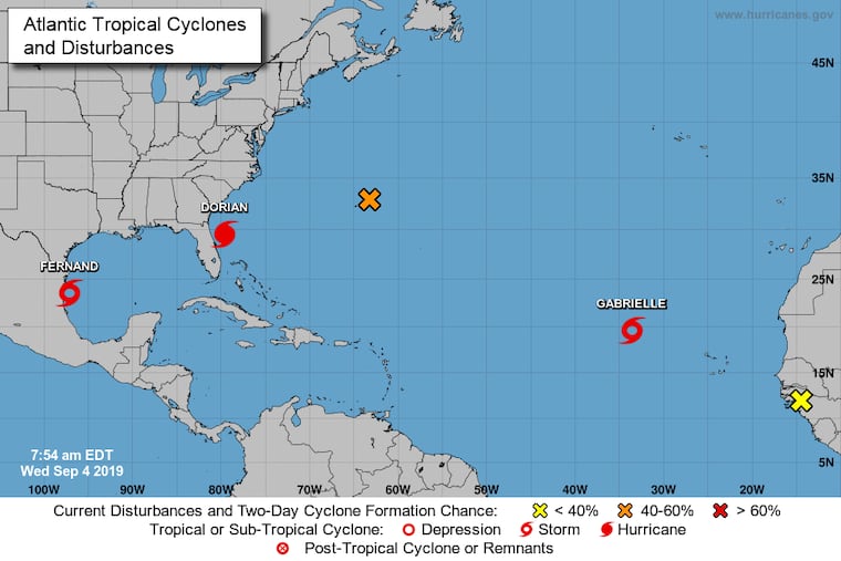
While Dorian’s Category 5 reign of fright has continued along the Southeast coast, with the Navy evacuating its ships and planes from the Virginia coast, the Atlantic Basin has been spawning a harvest of storms.
Early Wednesday, the National Hurricane Center decreed that a disturbance off the African coast had earned the name Gabrielle, the seventh tropical storm of the Atlantic Basin season.
Gabrielle is expected to remain a fish storm — staying out to sea — and never reach hurricane strength.
Nor will Fernand, named on Tuesday. Its top winds Wednesday reached 50 mph, and it has been downgraded to a tropical depression.
But a disturbance south of Bermuda has a 60 percent likelihood of becoming a named storm by the end of the workweek, and another one on the African coast has a 50-50 shot in the next five days.
So what explains the tropical-storm flurry? This is the climatological peak for the season in the Atlantic Basin, which includes the Gulf and the Caribbean.
In early and mid-September, sea-surface temperatures in the Basin reach their annual heights at the same time that vertical shearing winds that can rip apart incipient storms weaken, explains Philip Klotzbach, hurricane specialist at Colorado State University.
Having three storms in the Atlantic Basin isn’t all that unusual. In fact, it has happened in four consecutive seasons and in 28 or the last 54.
In fact, in 1998, quite an active season, four storms were spinning simultaneously, including the destructive Hurricane Georges.
There’s a chance that could happen again as the hurricane center sees a 50-50 chance that a disturbance south of Bermuda could become a tropical storm.
Dorian, after devastating the Bahamas and creeping ponderously northward off the Carolina coast, is forecast to lose intensity as it travels northward.
The Carolinas and the coasts as far north as the DelMarva Peninsula could see significant impacts from Dorian, and a hurricane warning were in effect from coastal Georgia to the North Carolina-Virginia border.
As a precaution, the Navy announced Tuesday it was moving its Hampton Roads-based ships. It said the ships would remain out to sea until the storm pulls away.
It took a similar action in advance of Hurricane Florence last year.
Dorian most definitely won’t be affecting Alabama, President Donald Trump’s comments notwithstanding.
And neither Fernand nor the storm south of Bermuda are expected to have any impacts on the U.S. mainland.
With Fernand and Gabrielle, the Atlantic season now is slightly ahead of schedule. On average the sixth named storm of the season forms on Sept. 8. Klotzbach says there might be more where they came from.
“The Atlantic is certainly quite conducive for hurricane formation right now,” Klotzbach said. “I would expect we’ll see a couple of hurricanes develop in the tropical Atlantic in the next couple of weeks.”
» READ MORE: Active Atlantic hurricane season now looking more likely, say government forecasters
