Philly is one of top cities most at risk of extreme rains
Current NOAA estimates say Philly could get about 3 inches of rain in an hour during a 100-year flood. A new model estimates it might be nearly 5 inches.
The Schuylkill River and Manayunk Canal overflowed onto Main Street in Manayunk following heavy rain from Hurricane Ida in 2021.Read moreAlejandro A. Alvarez / Staff Photographer
Storms galloped at times like wild stallions through the region starting last Friday, stomping on some towns while barely muddying their hooves on others.
But those whose cars plunged into flooded roads or whose possessions bobbed in basement water during the rash of no-named storms might not be surprised that experts say extreme rains are increasing in the Philadelphia region.
Upper Darby got drenched with nearly five inches of rain through Wednesday. Northeast Philly, Bala Cynwyd, and Chadds Ford all got well over four inches — the amount normally received for the entire month of June.
More heavy rains are possible Sunday and Sunday night, forecasters say.
The federal government has been underestimating the potential for extreme precipitation in many areas of the country, and Philadelphia is one of the top cities where that disconnect is greatest, according to a report released this week by First Street Foundation, a nonprofit that studies threats related to climate change. Though there’s no precise definition, extreme precipitation refers to intense, localized heavy rainfall within a short time.
The report looked at the widely used Atlas 14 flood precipitation frequency estimates by the federal National Oceanic and Atmospheric Administration (NOAA). It concluded that they fall short because they are based on an outdated method that doesn’t account for climate change.
That’s no small thing: While little known to outsiders, Atlas 14 is a gold standard used by government officials, civil engineers, and others to build infrastructure that can withstand flooding. Currently, state and local officials around the U.S. are planning how to use billions of dollars from the federal Infrastructure Investment and Jobs Act, passed in 2021 during the pandemic.
Consider that the New Jersey Department of Environmental Protection stated in a scientific report on climate change that extreme precipitation events have increased in the Northeast by 71% over the last 50 years, which is at a faster rate over the last three decades than any other region in the U.S.
Consider that the New Jersey Department of Environmental Protection (DEP) stated in a scientific report on climate change that id which is at a faster rate over the last three decades than anywhere else in the United States.
And a Pennsylvania Department of Environmental Protection assessment of climate threats states: “Increasing average temperatures and heavy precipitation and inland flooding emerged as the two highest-risk hazards by midcentury.”
To assist planners, First Street Foundation created its own model that it says captures climate-driven changes contributing to heavy rainfall and lays out flood risk across the U.S. The precipitation model used in the report has been published in the Journal of Hydrology.
The authors found significant differences across the country in NOAA Atlas precipitation estimates compared with actual rainfall risk in the area. That means current predictions of flood risk on people, communities, and property are too low, the authors say.
More frequent heavy rain for Philly
Philadelphia, according to First Street data, is one of the major cities at risk of more frequent severe flooding compared with NOAA Atlas 14 estimates for a “1-in-100-year flood.”
Think of flood estimates this way: A 10-year, 24-hour storm has a 10% chance of occurring in any single year. A 50-year storm has a 2% chance, and a 100-year storm, a 1% chance. Storm water management systems are designed to withstand storms based on these chances.
The current Atlas 14 model estimates that Philly could get about three inches of rain an hour during a 100-year flood. First Street’s adjusted estimates say nearly five inches are possible.
That means Philly has a chance of getting what NOAA calls a 1-in-100-year flood every 16 years. But those are just probabilities. In reality, 100-year floods can occur more than once in a year, or every few years.
“Our current understanding of precipitation risk is underestimated,” said Jeremy Porter, a Columbia University professor and head of climate implications at First Street Foundation. “Infrastructure and personal property are at a higher risk than design standards have been built to protect them from.”
The study cites a project in East Brunswick, N.J., using $86 million from the federal infrastructure money that’s designed to alleviate roadway flooding. But it’s based on Atlas 14 modeling to withstand a 15-year event. First Street estimates the same amount of rainfall, however, is expected to occur every four years.
John Moore, a NOAA meteorologist and spokesperson, said the agency doesn’t comment on outside research but called Atlas 14 estimates “the current authoritative source for precipitation frequency information and the national standard referenced in engineering design manuals and regulations.” It’s used for city and regional planning and the design of civil engineering and transportation infrastructure nationwide, he said.
The estimates are pulled from NOAA’s “scientific rigor and extensive observational network,” he said. But he noted NOAA is creating a new model, Atlas 15, that will take climate change into account. It won’t be ready until 2027, but NOAA will release a pilot version in 2024 for public comment.
More frequent extreme rain for local counties
Locally, Chester County is estimated to experience what’s now considered a 100-year storm nearly every decade.
Robert Kopp, a climate scientist at Rutgers University’s Department of Earth and Planetary Sciences, said shortcomings with Atlas 14 are well-known. He said First Street Foundation’s new data set is a “reasonable approximation as to what we’ll see when NOAA releases their new Atlas.”
Rising precipitation is a key signal of climate change, along with an increase in temperature, Kopp said.
“Rainfall has become a lot more intense,” he said.
“We’ve seen a lot of rain-driven flooding in our region,” Kopp said. “And if it rains intensely, rivers flood; groundwater floods. If you don’t have a storm water system to carry that away, you get the things that happened in Hurricane Ida, an iconic example.”
Clouds from Hurricane Ida encompass Philadelphia around 7:30 pm on Sept. 1, 2021.Read moreELIZABETH ROBERTSON / Staff Photographer
Homes damaged from the remnants of Hurricane Ida on Josephine Lane in Mullica Hill, N.J. on Thursday, September 2, 2021.Read moreMONICA HERNDON / Staff Photographer
Troy Bonnenberg picks at something in the ground near his damaged home on Marvin Lane in Mullica Hill, N.J. on Thursday, September 2, 2021. Remnants of Ida moved through the Philadelphia area Wednesday into Thursday, bringing heavy rain and widespread flooding. Multiple tornadoes were confirmed in the region.Read moreMONICA HERNDON / Staff Photographer
Homes damaged from the remnants of Hurricane Ida on Josephine Lane in Mullica Hill, N.J. on Thursday, September 2, 2021.Read moreMONICA HERNDON / Staff Photographer
Homeowner Ashley Thomas hugs a neighbor in front of her damaged home on Marvin Lane in Mullica Hill, N.J. on Thursday, September 2, 2021. Remnants of Ida moved through the Philadelphia area Wednesday into Thursday, bringing heavy rain and widespread flooding. Multiple tornadoes were confirmed in the region.Read moreMONICA HERNDON / Staff Photographer
Governor Phil Murphy speaks to the media in front of homes with significant damage from a tornado on Marvin Lane and Josephine Lane in Mullica Hill, N.J. on Thursday, September 2, 2021. Remnants of Ida moved through the Philadelphia area Wednesday into Thursday, bringing heavy rain and widespread flooding. Multiple tornadoes were confirmed in the region.Read moreMONICA HERNDON / Staff Photographer
A woman moves through the second story of a home with significant damage from a tornado on Marvin Lane and Josephine Lane in Mullica Hill, N.J. on Thursday, September 2, 2021. Remnants of Ida moved through the Philadelphia area Wednesday into Thursday, bringing heavy rain and widespread flooding. Multiple tornadoes were confirmed in the region.Read moreMONICA HERNDON / Staff Photographer
Family members embrace in front of homes with significant damage from a tornado on Marvin Lane and Josephine Lane in Mullica Hill, N.J. on Thursday, September 2, 2021. Remnants of Ida moved through the Philadelphia area Wednesday into Thursday, bringing heavy rain and widespread flooding. Multiple tornadoes were confirmed in the region.Read moreMONICA HERNDON / Staff Photographer
A child peeks into a home damaged from the remnants of Hurricane Ida on Josephine Lane in Mullica Hill, N.J. on Thursday, September 2, 2021.Read moreMONICA HERNDON / Staff Photographer
Flooding can be seen from the Manayunk Bridge, with everything between I-76 on the right and Main Street on the left submerged Thursday, Sept. 2, 2021.Read moreJUSTINE MCDANIEL / Staff
A residents surveys the scene along N. Croskey Street near Cherry Street. Heavy rain from Hurricane Ida is creating problems with flooding in Philadelphia and region on Thursday, September 2, 2021.Read moreALEJANDRO A. ALVAREZ / Staff Photographer
A flooded parking lot on S. 24th Street as seen from Walnut Street. Heavy rain from Hurricane Ida is creating problems with flooding in Philadelphia and region on Thursday, September 2, 2021.Read moreALEJANDRO A. ALVAREZ / Staff Photographer
A couple of women watch as a tow truck works to remove a car from flood water on N. 23rd near Race St. Heavy rain from Hurricane Ida is creating problems with flooding in Philadelphia and region on Thursday, September 2, 2021.Read moreALEJANDRO A. ALVAREZ / Staff Photographer
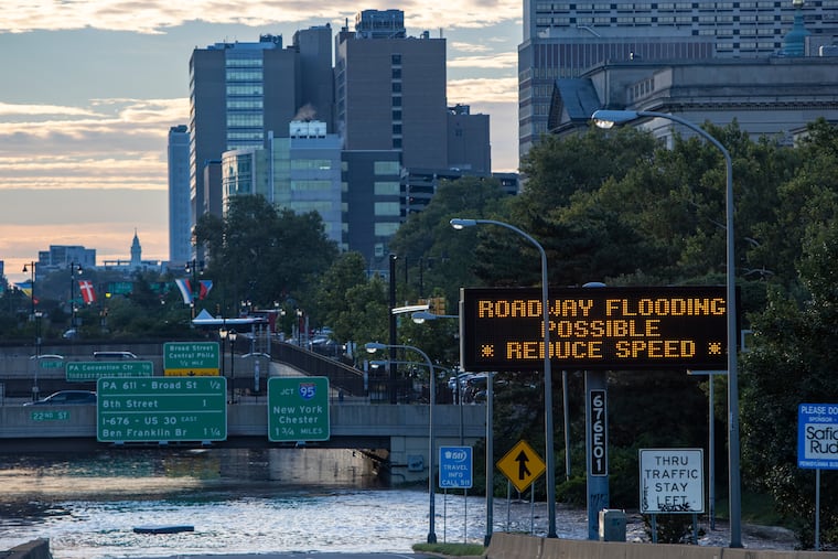
Sign informs motorists that there could be flooding on Vine Street expressway. Heavy rain from Hurricane Ida is creating problems with flooding in Philadelphia and region on Thursday, September 2, 2021.Read moreALEJANDRO A. ALVAREZ / Staff Photographer
Cars cross flooded intersection of Arch Street at 22nd Streett. Heavy rain from Hurricane Ida is creating problems with flooding in Philadelphia and region on Thursday, September 2, 2021.Read moreALEJANDRO A. ALVAREZ / Staff Photographer
A tow truck works to remove a car from flood water on N. 23rd near Race St. Heavy rain from Hurricane Ida is creating problems with flooding in Philadelphia and region on Thursday, September 2, 2021.Read moreALEJANDRO A. ALVAREZ / Staff Photographer
I-676 the Vine Street expressway is underwater. Heavy rain fell over Philadelphia and region Wednesday into Thursday. The areas near the banks of Schuylkill River and in Manayunk are flooding. Photograph from Thursday morning September 2, 2021.Read moreALEJANDRO A. ALVAREZ / Staff Photographer
A view of Lincoln Drive from Henry Avenue bridge. Heavy rain from Hurricane Ida is creating problems with flooding in Philadelphia and region on Thursday, September 2, 2021.Read moreALEJANDRO A. ALVAREZ / Staff Photographer
A view of Main Street Manayunk as seen from Shurs Lane. Heavy rain from Hurricane Ida is creating problems with flooding in Philadelphia and region on Thursday, September 2, 2021.Read moreALEJANDRO A. ALVAREZ / Staff Photographer
A view of the rising Schuylkill River, caused by Hurricane Ida, at the Market St bridge in Phila., Pa. shortly after 3 am on Sept. 2, 2021.Read moreELIZABETH ROBERTSON / Staff Photographer
Phila. firefighters stop a USPS tractor trailer from driving down N 23rd St at Race St. in Phila. Pa. just before 5 am Sept. 2, 2021. Flooding from Hurricane Ida is causing major flooding around the Phila. area.Read moreELIZABETH ROBERTSON / Staff Photographer
Flooding from Hurricane Ida makes the Vine St. Expressway near 22nd St. impassable around 4:20 am on Sept. 2, 2021.Read moreELIZABETH ROBERTSON / Staff Photographer
A man watches an angry Schuylkill River from the John F Kennedy Blvd entrance to the Schuylkill River Trail in Phila., Pa. just after 3 am on Sept. 2, 2021.Read moreELIZABETH ROBERTSON / Staff Photographer
Traffic along I-76 heading into Center City just before turn off for I-676. Heavy rain from Hurricane Ida is creating problems with flooding in Philadelphia and region on Thursday, September 2, 2021.Read moreALEJANDRO A. ALVAREZ / Staff Photographer
Part of a structure floats down Main Street at Shurs Lane in Manayunk. Heavy rain from Hurricane Ida is creating problems with flooding in Philadelphia and region on Thursday, September 2, 2021.Read moreALEJANDRO A. ALVAREZ / Staff Photographer
Damage at Upper Dublin High School Thursday, Sept. 2, 2021, a day after Ida passed through the region.Read moreHEATHER KHALIFA / Staff photographer
People walk past heavy damage to Upper Dublin High School in Fort Washington, Pa. on Thursday, Sept. 2, 2021. The region is continuing to deal with fallout after the remnants of Hurricane Ida tore through Wednesday evening, causing flooding and heavy damage.Read moreHEATHER KHALIFA / Staff Photographer
People take in the damage behind Upper Dublin High School in Fort Washington, Pa. on Thursday, Sept. 2, 2021. The region is continuing to deal with fallout after the remnants of Hurricane Ida tore through Wednesday evening, causing flooding and heavy damage.Read moreHEATHER KHALIFA / Staff Photographer
People walk underneath the Fort Washington Expressway on Loch Alsh Ave. and toward Upper Dublin High School where homes and schools were damaged from last night’s storm in Fort Washington, Pa. on Thursday, Sept. 2, 2021. The region is continuing to deal with fallout after the remnants of Hurricane Ida tore through Wednesday evening, causing flooding and heavy damage.Read moreHEATHER KHALIFA / Staff Photographer
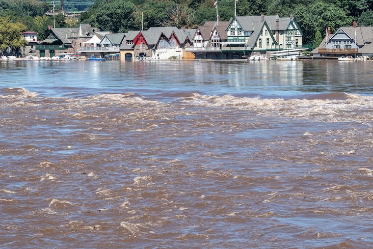
Boathouse Row is shown on Thursday, Sept. 2, 2021., a day after heavy storms and flooded waters from the Schuylkill River in Philadelphia, Pa.Read moreJOSE F. MORENO / Staff Photographer
Boathouse Row is shown on Thursday, Sept. 2, 2021., a day after heavy storms and flooded waters from the Schuylkill River in Philadelphia, Pa.Read moreJOSE F. MORENO / Staff Photographer
Andrew Solimeo, 30, of Downingtown, Pa., and his girlfriend, Morgan Bonsall, 29, of Downingtown, Pa., are cleaning out the first floor of their home along Brandywine Avenue in Downingtown, Pa., on Thursday, Sept., 2, 2021. Solimeo and Bonsall left their home with their two cats and dogs on their shoulders as they cross the street to their neighbors house. The water levels were about five feet high.Read moreTYGER WILLIAMS / Staff Photographer
People look over parking lot at the Pointe at Phoenixville Riverworks in Phoenixville with flooding the French Creek, Thursday, September 2, 2021Read moreSTEVEN M. FALK / Staff Photographer
The Montgomery County coroner removes a victim of the storm from a house on 3rd Street in Bridgeport. The victims' house is located about 200 yards from the Schuylkill River, Thursday, September 2, 2021Read moreSTEVEN M. FALK / Staff Photographer
Trying for a better view people under the Conrail trestle in Phoenixville on Main Street Rt.29 looking towards Mont Clare with a car under water from flooding along the Schuylkill river, Thursday, September 2, 2021Read moreSTEVEN M. FALK / Staff Photographer
Lorraine Geiling, 61, of Downingtown, Pa., looks into the first floor of an apartment she is leasing that was flooded last night along Manor Ave., and E Lancaster Ave., in Downingtown, Pa., on Thursday,Sept., 2, 2021. “This is really devastating,” Geiling said. “Never had water in my first floor apartment. I don’t have any flood insurance. I don’t have the money to pay for this. This is my lively hood.”Read moreTYGER WILLIAMS / Staff Photographer
A home is missing its roof, damaged by a possible tornado on the corner of Josephine and Marvin Lanes in Mullica Hill, Harrison Township, Sept. 1, 2021.Read moreTOM GRALISH / Staff Photographer
An officer inspects a home without a roof, damaged by a possible tornado on Marvin Lane in Mullica Hill, Harrison Township, Sept. 1, 2021.Read moreTOM GRALISH / Staff Photographer
A home damaged by a possible tornado on Josephine Lane in Mullica Hill, Harrison Township, Sept. 1, 2021.Read moreTOM GRALISH / Staff Photographer
A home damaged by a possible tornado on the corner of Josephine and Marvin Lanes in Mullica Hill, Harrison Township, Sept. 1, 2021.Read moreTOM GRALISH / Staff Photographer
The rear window of a car is damaged by a possible tornado on Josephine Lane in Mullica Hill, Harrison Township, Sept. 1, 2021.Read moreTOM GRALISH / Staff Photographer
Butler Pike near Morris Rd. is shut down in Montgomery County on Sept. 1, 2021. Two submerged vehicles are in the background.Read moreCHARLES FOX / Staff Photographer
Ida is an example
Indeed, the remnants of Ida battered the Philadelphia region, flooding the Schuylkill Expressway and spawning tornadoes across suburban Pennsylvania and New Jersey. The rainfall totals from Ida on Sept. 2, 2021, were eye-opening: more than nine inches in Coatesville, eight in Perkasie, and eight in Phoenixville.
In Central Jersey, Mercer and Hunterdon Counties saw nine or more inches.
Scientists at the time said the storm was supercharged by climate change. Ida was fueled by warmer-than-normal temperatures in the Gulf of Mexico. When it arrived in Philly, the weather in August had been much hotter and wetter than normal: 2.3 degrees above normal and 6.18 inches of rain — 144% over the average for the last 20 years.
“Climate change makes everything more intense,” Kopp said.