On the 30th anniversary of Hurricane Andrew, you might consider having a battery-powered radio handy
Buzz-sawing across Florida was more tornado than hurricane. It occurred in a season that was off to an even slower start than this one.
Winds tossed boats as if they were toys, smashed billboards, stripped paint off of buildings, and unplugged much of metro Miami.
What buzz-sawed through South Florida on this date in 1992 was more tornado than hurricane.
“Friends, here is what I want you to do,” TV meteorologist Bryan Norcross recalled telling an audience that could hear him only on battery-operated radios in the early-morning hours. “I want you to get a mattress off the bed and get it ready.” That, he said, might be the best shield from the dangerously flying debris.
Norcross, a South Jersey native who 20 years later would give Sandy its enduring first name — “Superstorm” — wasn’t just another media voice available for those in the Miami region enduring the siege of Andrew in the early-morning hours of 1992. His was the only voice, thanks to a deal he fortunately had cemented with a local rock station just the week before.
» READ MORE: Forecasters still expect a brisk Atlantic hurricane season
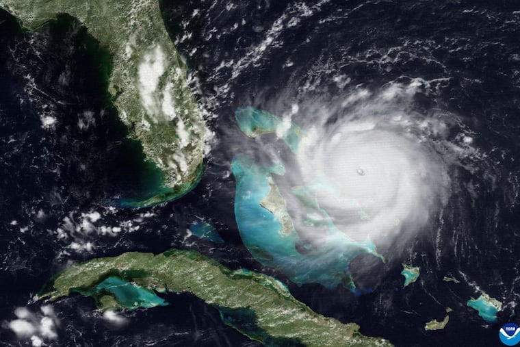
Andrew made landfall at 5 a.m. as a Category 5 — at the time only the third Category 5 to land on U.S. soil — just south of Miami with top winds at 165 mph and a 16.9-foot storm surge. It then ripped across the state and into the Gulf of Mexico, making a second landfall in Louisiana with 115 mph winds.
It changed the way the nation responds to disasters. It was a horrific reminder of the power of hurricanes, a warning shot of what was to come — and what continues today.
And despite the amazing scientific progress of the last 30 years, it underscored a weakness in hurricane forecasting that could remain an issue “probably forever,” Norcross said.
It was blamed for as many as 65 deaths. And by one estimate, if it hit the same place today damage would top $115 billion.
It leveled Homestead, Fla., and only an amazing alignment of circumstances kept Andrew from being even more devastating. Had the eye come ashore just 7 miles to the north, Andrew would have directed its peak ferocity directly on Miami à la the Great Miami Hurricane of 1926, when a whole lot fewer people — and buildings — were in the way.
About Andrew
On Aug. 17, which would turn out to be an important day in Norcross’ career, Andrew became the first tropical storm of 1992. Three days later, it was on the brink of retirement.
» READ MORE: The Great Miami Hurricane of 1926 made a direct hit on the city
Air reconnaissance was unable to identify a center and “only a diffuse low-level circulation center remained,” according to the National Hurricane Center, which wisely erred on the side of conservatism and let Andrew keep its name.
Then on Aug. 22, the storm regrouped and blew up into a hurricane. It underwent a rapid and unexpected intensification as it sped toward the Florida coast.
“Many people left Miami and never came back, they were so traumatized,” said Stanley Goldenberg, a Hurricane Research Division scientist at NOAA’s Atlantic Oceanographic and Meteorological Laboratory. He was living just outside the Miami area when Andrew hit. He and eight other people famously stayed in his house while Andrew ripped it to pieces, even though it was made of concrete.
Winds were clocked at 100 mph at Miami’s airport, but the city, and probably the nation’s taxpayers, did catch a tremendous break. Andrew was a geographically small storm. Its peak winds were confined to a narrow corridor, and an analysis showed that they came within 7 miles of Miami, said Norcross, now hurricane specialist for Fox Weather.
What’s more, “that peak storm surge hit at the least-populated place on the Florida coast,” he said, although it did wipe out Burger King’s national headquarters.
About Norcross
An engineer and a former TV news producer, Norcross became a meteorologist and eventually went to work at Miami’s WTVJ-TV, where he discovered that its transmitting tower had no chance to survive a hurricane. He figured that if a potent storm struck, people would lose power and have to rely on battery-powered radios for information. So the only way for the station to stay in contact with the audience would be through a radio line.
After negotiation, a rock station in Fort Lauderdale agreed to connect the TV station’s line to its transmitter. During Andrew, Norcross and two colleagues holed up in a makeshift bunker, and kept listeners apprised of the storm’s progress and offered advice on how to survive it, including using their mattresses as debris shields.
“Bryan’s expertise and cool head probably saved many lives,” said Goldenberg.
Goldenberg, whose wife had just given birth, weathered the storm at his home with two other adults, six children, and a cat. Remarkably no one was injured.
Andrew’s legacy
By all accounts, the disaster response was a disaster itself. The General Accounting Office ripped the Federal Emergency Management Agency’s performance.
“You can’t not have the federal government respond to something that’s on the news every day,” said Norcross.
Post-Andrew, FEMA underwent a major reorganization after President Bill Clinton took office in January 1993.
» READ MORE: They aren't Andrew, but Philly has had its share of tropical-storm remnants
He named James Lee Witt, who had served under then-Gov. Clinton as state emergency chief in Arkansas. as FEMA director. It marked the first time FEMA had been run by someone with actual emergency-management experience. Changes followed.
Rather than waiting to be summoned after a storm had done its damage, the GAO noted, FEMA had become “more proactive.” When storms threatened, FEMA officials would set up shop at the hurricane center to monitor conditions.
Andrew was a major impetus for hurricane research, and track forecasts now are quantum leaps better than they were 30 years ago. The five-day track outlook today is as good as the 48-hour forecast in 1992, said Goldenberg.
Rapid intensification, however, remains an issue, said Norcross. “We’re drastically better off than we were in 1992, but to this day and probably forever, poorly developed or just-developing storms will always have forecast errors.”
“The intensification is a whole different ballgame,” said Goldenberg, but he said researchers are making progress, and “nobody is pulling their hair out and saying we can’t do this.”
A sea change
The 2022 Atlantic hurricane season is off to a slow start with just three named storms so far, but it is well ahead of 1992′s. Andrew was about two months behind long-term averages for a first-named storm, not all that surprising.
Historically, “lull” and “active” hurricane periods have alternated in 25- to 40-year cycles. Andrew came near the end of a lull that began in 1970 and that coincided with a coastal building boom.
It ended emphatically in 1995, and the active period hasn’t let up since. Some research holds that as a result of climate change, the Atlantic Basin, which includes the Gulf of Mexico and Caribbean, will be active permanently, however that remains a subject of continued analysis.
Forecasters insist that this season is about to pick up. On Tuesday night, the hurricane center was monitoring two potential Atlantic storms.
Whatever else happens, Norcross suggested it is not a bad idea to keep a battery-operated radio around in case of power and internet outages.
For all the amazing technological advances since Andrew, he said, “we are so dependent on a precarious communication system.”
