Delaware owns a small chunk of South Jersey
New Jersey's "little oddity" gets you to Delaware without wetting your feet.
SOUTH JERSEY, or (maybe?) DELAWARE — In Salem County, N.J., about seven miles south of the Delaware Memorial Bridge, a small chunk of land abuts the Delaware River.
The secluded, uninhabited area was created by the U.S. Army Corps of Engineers, which has deposited river-dredged material there since 1898.
It’s all quite unremarkable except for one thing: A large portion of the location, which has come to be known as Killcohook, is actually in the state of Delaware.
Thanks to an unusual border agreement between William Penn and King Charles II of England, signed 340 years ago, one-third of the 1,430-acre site is physically attached to South Jersey, but technically sits in the First State, the mainland of which is a little more than a mile across the river. The Corps has authority over the tiny swath of land.
Adjoining Fort Mott State Park and Finn’s Point National Cemetery in Pennsville, the little-known spot has been nicknamed “The Baja” by locals after the region in northwestern Mexico. It’s meant to describe a windswept wilderness — a place apart.
“Down in The Baja through the years, kids have been drinking beer and running dirt bikes, but nobody’s really been bothered by them,” said Walter Ray, Pennsville solicitor. “There’s nothing out there but grass and sand dunes.”
Technically, if a crime were to be committed in Killcohook, authorities in Delaware would have to be notified, Ray said, adding, “Pennsville has no jurisdiction there.” As it happens, no one can remember much serious lawlessness occurring.
But, he added, “We have found bodies there because people will jump off the Delaware Memorial Bridge, and wash up, and it’s awful.”
“We protect the body and call Delaware authorities.”
Andres Grant, Fort Mott State Park historian, calls Killcohook New Jersey’s “little oddity,” adding, “It’s how you can get to Delaware without your feet getting wet. When I tell people about it, it blows their minds.”
For those in Delaware who know about the minuscule map dot, “that land is a symbol,” said hydrologist Gerald Kauffman, director of the University of Delaware Water Resources Center.
“Delaware is a small state and wouldn’t want to give up more land. It’s a matter of state pride to own Killcohook. And there have been case studies” to definitively prove Delaware’s provenance, making ownership that much sweeter.
12-mile circle
When William Penn and King Charles II (the last king by that name until Prince Charles ascended to the throne and became Charles III on Sept. 8) were dividing up the colonies, they agreed to separate Delaware from Pennsylvania with a 12-mile circle drawn around New Castle, Kauffman said. The provision was signed on Aug. 24, 1682.
Everything within the arc was Delaware’s, including the entire Delaware River over to the low-tide mark of the New Jersey shoreline. As a result, these days, Delaware owns around 26 miles of the Delaware River from the northern tip of what is now Artificial Island, Lower Alloways Creek, N.J., north to roughly where Logan Township, N.J., now sits, Kauffman said. (Officials say the nuclear facilities on the island are in New Jersey.) One caveat is that the 45-foot-deep shipping channel in the center of the river is under Corps jurisdiction.
The circular boundary may be the only such political border in the United States, historians have said, adding that it’s quite unusual for a river that divides two states not to be split 50-50.
Centuries ago, just marshes existed at the New Jersey low-tide mark. But as the Corps began dredging the river, it pumped enough sand, silt, and gravel into the water to create land, Corps spokesperson Ed Voigt said.
Throughout the years, the odd division of the river has spawned controversy.
In 1872, the armed tugboat Falcon out of Wilmington crossed the river to the Jersey side to inform fishermen they were actually in Delaware waters without licenses. Some arrests were made, according to Grant.
Historians write that New Jersey has disputed Delaware’s river boundary in three cases that reached the U.S. Supreme Court. New Jersey lost each time.
In the most recent disagreement in 2008, energy giant BP was prevented from building a $700 million liquefied natural gas terminal along the Delaware River off Logan but technically in Delaware. Delaware had rejected the request for safety reasons because unloading natural gas at the site would have violated a Delaware law that limits industrial activity along the coast. Writing for the majority, the late Justice Ruth Bader Ginsburg upheld the sanctity of the original 12-mile border.
Jokingly, New Jersey legislators said they’d escalate the dispute by bringing Battleship New Jersey down to face off against recalcitrant Delawareans, whose House of Representatives countered by saying they’d call up the National Guard. No shots were fired.
Foxes and phragmites
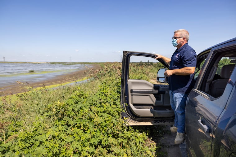
On a recent warm day, Tim Rooney, project manager with the Corps’ Philadelphia district, led a tour of Killcohook in his four-wheel drive truck.
“Under Army Corps authority, this is like a federal preserve at this point,” he said. “We’ve put up steel gates to keep the public out. But it’s not Fort Knox; it’s open wilderness.”
Rooney said the area is filled with deer, foxes, goldfinches, and mosquitoes. Phragmites, eight-foot-high reed grasses, line the unpaved roadway, which runs along 60-foot-high earthen dikes that separate the areas, known as cells, into which river material is pumped.
He said the 2-to-3 million cubic yards of river material the Corps dredges annually are tested twice for pollutants, once in the river, once after removal. The Corps sells or gives away the dug-up sand and gravel, and the silt is used for topsoil.
“This place is odd,” Rooney concluded, eyeing the landscape still growing under his feet. “I have to say, this place is unique.”
