Is this the ‘greatest, worst map’ ever of Philly?
It's "whimsical" and "a trend in neighborhood art," according to the company behind the map.
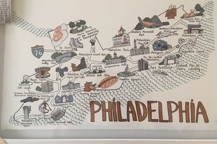
What if you had to cross a giant hot dog to get from Reading Terminal Market to Franklin Square? What if cruise ships pulled into Port Richmond? What if Lincoln Financial Field was an island in the Delaware?
Well wonder no more, Philadelphians.
In what may be the best worst map ever created of Philadelphia, all those things and more are possible.
A picture of the cartographic catastrophe was posted to Twitter Tuesday by journalist Dan McQuade, a Philly resident and an editor at Deadspin.
McQuade, who deemed the piece “the greatest, worst map of Philadelphia” said it was made by a company called Marmont Hill and was a gag gift from his future mother-in-law, who bought it at the HomeGoods in Montgomeryville.
A manager at the Montgomeryville HomeGoods said he hadn’t received any complaints about the map and wasn’t sure where it came from.
“Everyday is Christmas here,” the manager said. “We get everything in from everybody everywhere. We have no specific vendors.”
Parvez Taj, the creative director at Marmont Hill, said the map was intended to be fun and decorative, as opposed to geographically sound.
“We create these maps. They’re classified as whimsical. It’s a trend in neighborhood artwork,” he said.
Here are the biggest questions we have about this Philly map that’s all over the map.
In what world are these landmarks?
Points on the map include Sugarhouse Casino, Philadelphia Mills mall (it’ll always be Franklin Mills to us), an indoor rock-climbing gym, two golf courses, and a trio of unlabeled shopping bags in the Northeast.
We’re not sure what you’re going to find in those bags, but it must be important!
Landmarks that didn’t make the cut include the Liberty Bell, the first post office, and Ben Franklin’s grave.
Taj said the chosen sites must have meant something to the artist who created the map. He did not have the artist’s name at hand.
Juniata where you at?
In our world, the city’s Juniata section abuts Northeast Philly. But in the multiverse where this map was created, Juniata is between Independence Hall and the Philadelphia Museum of Art.
It’s interesting to imagine what it’d be like to have a working-class neighborhood between two of the city’s biggest tourist attractions, but it’s not a reality.
“It’s not a Google Map to get someone from A to B," Taj said, when asked about the discrepancy. "It’s more just like ‘Hey! This is Philadelphia, here’s a few icons that we’ve pulled out that we think are worth mentioning.’”
And while Northeast Philly’s Port Richmond section is generally in the right vicinity on the map, it is also somehow south of City Hall, which is totally wrong.
It’s always sunny-side up
We don’t like that Philly’s always associated with cheesesteaks and soft pretzels any more than you do, but we’ve come to accept and embrace it, just like the calories that come with them.
So we were thoroughly confused by the two giant food items on this map: sunny-side-up eggs and a hot dog.
“I can agree with you, they are odd choices,” Taj said. “It’s a light, fluffy, whimsical map.”
Which brings us to our next question...
A grave mistake
One of the points of interest listed is decidedly not whimsical and decidedly not in Philly: Shalom Memorial Park, a cemetery.
Shalom Memorial Park is in Huntingdon Valley, Montgomery County, more than 20 miles away from Center City Philadelphia.
Why did the artist include a suburban cemetery? Taj said he or she must have “identified that as an important element in the Philadelphia area.”
We are not alone
Other maps listed on Marmont Hill’s website contain inaccuracies as well.
Take, for instance, the whimsical state map of California. The map, which was removed from the site after its errors were brought to Taj’s attention, included sites like Reno (which is Nevada) and the Salt Lake Temple (which is in Utah). Alcatraz Island was also on land on the map.
Taj seemed genuinely surprised to learn of the inaccuracies.
“I have to emphasize the artistic aspect as opposed to the technical aspect,” he said of the maps. “Although we do try to adhere to geographic locations, if it’s not perfect, it’s something we’re working towards.”