Flooding and 50mph+ winds hit the Shore, while Philly sees rain and breeziness
The worst for the Shore will be flooding during high tides on Sunday afternoon and on Monday in the early morning and afternoon, while Philadelphia may only have minor tidal flooding.
The storm the Philadelphia region spent days prepping for smashed into the Jersey Shore on Sunday, bringing flooding and gusts exceeding 50 mph. More flooding was forecast overnight and for Monday afternoon.
Shore communities experienced moderate flooding in the first of three expected rounds of high-tide flooding during the storm.
Low-lying areas in Atlantic and Cape May Counties were expected to see waters 2 to 3 feet above normal during high tides very early Monday morning, and Monday afternoon, the National Weather Service in Mount Holly forecast.
“Roads are definitely going to be impassable with tidal flooding,” and some infrastructure could be damaged, said Eric Hoeflich, a weather service meteorologist.
New Jersey declared a disaster emergency that began Saturday and will last into Monday.
While nasty for the Shore, the nor’easter brought less rainfall than expected to the areas around Philadelphia.
Along the Delaware and other inland tidal rivers, the effect is expected to be much more muted, though there could still be minor flooding up to a foot above normal. Forecasters advised against leaving cars parked in areas prone to tidal floods.
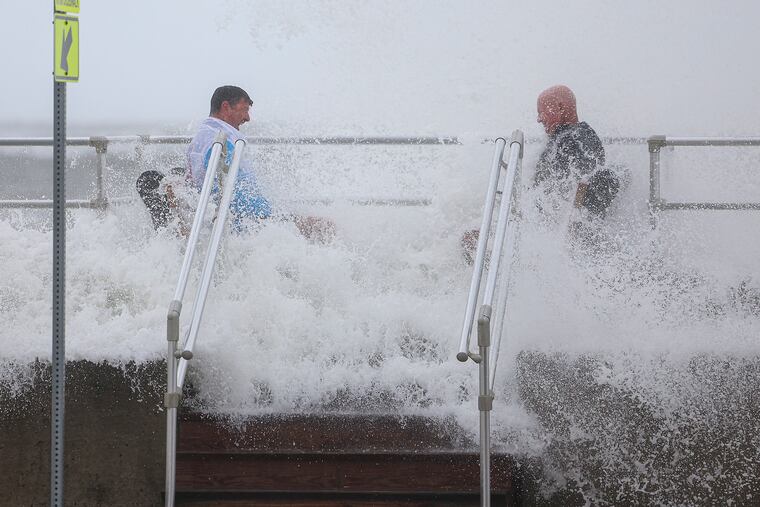
Storm watchers get sprayed
Onlookers headed to the boardwalk in Wildwood to catch glimpses of the waves crashing into the beach. Some got drenched as the waves crashed into them.
Weather Service meteorologist Patrick O’Hara doesn’t advise these excursions, noting that there are plenty of dramatic waves to be seen on TV.
“They’re looking for the flooding and they end up getting into barrier islands and then the water floods the islands and then they can’t get off,” he said. “And that’s kind of what situations we don’t like. ... Not really the greatest idea to go looking around.”
Rain drenches the Shore, with less inland
Shore communities had already received roughly an inch of rain by late Sunday afternoon. Forecasters said another 1 to 1½ inches could arrive by the end of the storm on Monday.
One surprise for meteorologists was the light amount of rain Philadelphia received. Early forecasts saw the entire region being drenched.
“The tricky part of the forecast has been the rain. We’re not getting very much in Philadelphia area,” O’Hara said. “There’s just been some spits and some very light rain.”
Through Monday, Philly could receive roughly a half-inch of rain.
“There’s been a lot of dry air to the western part of the storm, which hasn’t really yielded to the rain as along the Shore areas.”
The rain led to some changes to the Navy and Marine Corps’ 250th anniversary celebration in Philadelphia on Sunday. A picnic for veterans on Independence Mall was canceled, while a concert headlined by Patti LaBelle was moved indoors.
Winds arrive Sunday
Wind accompanied the flooding in Shore towns.
“We’ve already seen, like on the barrier islands, that there’s already been some gusts over 50 miles per hour,” O’Hara said. “A few gusts over 60 would not be surprising.”
Sustained winds at the shore were in the 20- to 30-mph range. In Philadelphia, sustained winds were expected to be around 15 mph, with gusts up to 40 mph.
Sunday was expected to be the worst day for wind, with lower speeds forecast for Monday, while flooding could continue into Monday evening.
A ‘slowly, slowly, slowly’ developing storm
The nor’easter developed to the south of the region. “It’s been slowly, slowly, slowly moving north,” Hoeflich said.
With several days of forecast alerts, Shore communities and residents had a chance to prepare, Hoeflich said.
“And we’ve gotten some feedback that people have prepared, moving cars to higher grounds and things like that,” Hoeflich said.
O’Hara added that, despite the Philadelphia impacts being relatively light on Sunday, the storm lived up to expectations on the Shore.
“It’s a rather significant storm for this time of the year,” he said, adding that could continue on Monday: “So it’s definitely something to pay attention to.”
