Schuylkill River trail guide honored by British cartographers
The guide was created for all kayak enthusiasts, from first-timers to seasoned explorers.
The British Cartographic Society just put the Schuylkill recreational area on the international map.
Brian Swisher, a Reading designer and cartographer, recently won two commendations from the society for his work on "A Paddler's Guide to the Schuylkill River Water Trail," published in December for the Schuylkill River National and State Heritage Area.
Swisher, an avid kayaker, received the "highly commended" honor for the John C. Bartholomew Award, which is presented for "originality and excellence in the field of thematic cartography with emphasis on effective communication." He also received the "commended" honor for the Stanfords Award, which recognizes printed maps.
"It's a pretty big deal," said Swisher, 67. A graphic designer by trade, he spent about 3,000 volunteer hours over four years on the project.
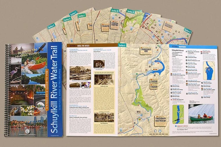
The spiral-bound, 20-page booklet is printed on waterproof stock and features detailed tri-fold maps of the 18 sections of the 115-mile waterway — from Schuylkill Haven Island Park just south of Pottsville to Bartram's Garden in Philadelphia.
The guide was created for all kayakers, from first-timers to seasoned explorers.
"It was a chance for me to do something to give back for all the good things the Schuylkill River Heritage Area does," he said.
The judges panel commended Swisher's guide for being "very usable."
"A thorough, usable guide for planning and executing a trip along the river – appeals to everyone with lots of associated information, clearly laid out, good clear photography and labels. Maps have all associated contextual information," the judges commented.
Other awards went to a map on Baboon migration, a guide to the Dragon Back race in Wales (the toughest five-day mountain race in the world), and a historical map of Kingston-upon-Hull in England.
The paddler's guide was produced after the Schuylkill River Heritage Area noticed a growing interest in river recreation. Trail manager Bob Folwell enlisted Swisher, who then tapped members of the Keystone Canoe Club, of which he is a member, for their "brain power." In total, about 60 contributors helped develop the trail guide, he said.
"It has been a collaboration to pull this together up and down the river," Swisher said.
The guide offers notes on landings, rapids, cautions, bridges, dams, or remnants to watch for, as well as other points of interest including parking, restrooms, picnic facilities, groceries, restaurants, hotels, ATMs, and medical facilities. Short sidebars tell the stories that have helped shape the Schuylkill watershed and riverside communities. Colorful photos feature some of the river's wildlife and fish.
"In some cases, they are the best maps you can get of the bike trails," Swisher said.
The $40 guide is available through the Schuylkill River Heritage Area at schuylkillriver.org.
