Bolaris: Winter not over yet; more snow coming
Don’t let the calendar fool you. Winter is not over yet. Spring may officially arrive at 6:45 p.m. Friday, but we’re in for a bracing encounter with a very-late-in-the-season snowstorm as tomorrow begins.
Don't let the calendar fool you. Winter is not over yet. Spring may officially arrive at 6:45 p.m. today, but we're in for a bracing encounter with a very-late-in-the-season snowstorm.
The setup
A modified polar air mass was in place with a storm intensifying (not rapidly) up from the North Carolina coast first thing this morning. The atmosphere was still cold enough to produce all snow as it began arriving about 6 a.m.
A temperature profile through the layers of the atmosphere is pointing toward a borderline transition to rain in the city during the afternoon.
If the same profile was to take place in mid-February instead of mid-March, I would be calling for an all snow event.
But due to the angle of the sun and with the bulk of the precipitation taking place during the afternoon, this should be enough to change the snow over to rain in the city and all across South Jersey and Delaware.
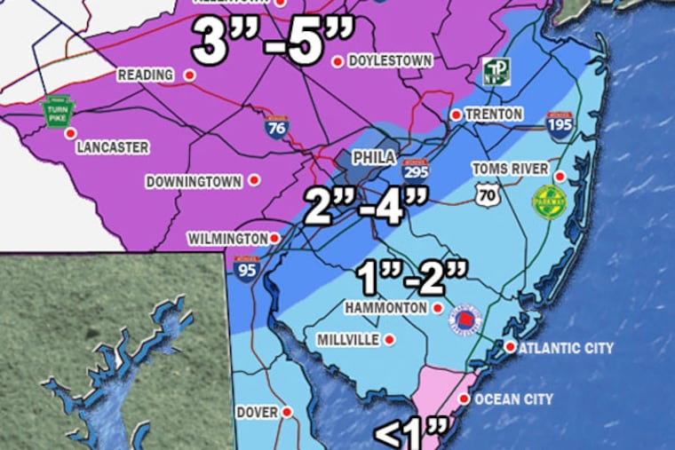
In general, 1 to 3 inches should fall, sticking to grassy surfaces before it's washed away by the rain.
Expect the snow to cause travel headaches if your heading northwest of the Blue Route or north of the Pennsylvania Turnpike. We'll see more snow accumulating in those areas with the possibility of it coating untreated secondary roadways.
The storm will pull away between 6 and 8 p.m. with all precipitation ending.
Snow intensity will pick up later this morning after the morning rush. Generally, look for 1-2 inches in the city, before changing over to sleet and then rain during the afternoon. Temps will hover around 34 degrees.
5 to 8 a.m.: Wet snow arrives.
9 a.m. to noon: Wet snow, slushy accumulations on grassy surfaces.
Noon to 2 p.m.: Wet snow mixes with sleet and changes to rain.
2 to 7 p.m.: Rain in the city and a wintry mix north & west
8-10 p.m.: Storm passes, then clearing. Low 33
Saturday: Sun & clouds milder. High 55
Northwestern suburbs
6 to 9 a.m.: Snow arrives
9 to 2 p.m.: Snow starts to mix with sleet
2 to 3 p.m.: Mix to rain, except for the Lehigh Valley and the Poconos, where it will remain all snow.
7 to 8 p.m.: All precipitation ending.
Contact John Bolaris at jweatherboy@yahoo.com or @johnbolaris