Philadelphia police launch website of maps listing crimes
Want a rundown on crime in your neighborhood over the last day? Are you a techie who can write code to display a digital map of gun crime in Philadelphia?
Want a rundown on crime in your neighborhood over the last day?
Are you a techie who can write code to display a digital map of gun crime in Philadelphia?
Are you a scholar who wants to analyze crime trends year after year?
All of this is now doable under a public-information initiative rolled out Wednesday by Police Commissioner Charles H. Ramsey and top information officials of the Nutter administration.
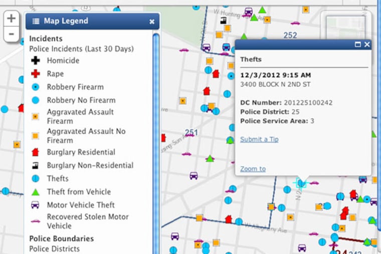
Now anyone with a browser can look at maps showing crime in the city over the previous 30 days at http://www.phila.gov/map. The display will update daily.
Programmers or others interested in a complete set of crime data dating to 2006 can download it free at http://www.opendataphilly.org.
Users can also go to that address to use a software tool known as an API, or application program interface, to access the geocoded crime-by-crime data, 594,000 crimes in all.
The data provide details for the seven most serious crimes as defined by the FBI: four violent crimes - murder, rape, robbery, aggravated assault - and three property crimes - burglary, theft, and auto theft.
Viewers can see crime by day, time, and block. The data for robberies and assault indicate whether a gun was involved.
For privacy reasons, victim information is not provided.
Ramsey noted the data reflect the initial response by police and do not include subsequent work by detectives. Still, he said, "Some information is better than no information. That's why we're trying to push it out as quickly as possible."
Adel Ebeid, the city's chief innovation officer, said the public release would permit people to use raw data to judge for themselves the performance of city government.
Mark Headd, Philadelphia's chief data officer, said the maps with crime data would soon be overlaid with other data from city departments, such as housing information, to show an ever-richer picture of life in Philadelphia.
On Wednesday night, Headd was scheduled to speak at a tech gathering to brief programmers on the newly available police data.
Grant Ervin, the city official in charge of computerized mapping for the Police and Fire Departments, helped supervise the project.
He said he hoped outside programmers would use the data in unexpected ways.
"Show how me something I don't know and I can apply it - and we can make the city a better place," Ervin said. "That's what I'm hoping for."
The release is a more sophisticated version of data police have previously made available though a private website, reachable via http://phillypolice.com/about/crime-statistics.
Philadelphia is among a growing number of cities, including Baltimore and Chicago, that have made this type of crime information public.