Seawall project nearing completion on Jersey Shore
BRICK TOWNSHIP, N.J. - You won't be able to see it when it's finished, because the seawall that extends three and a half miles through two beach towns will be covered in sand and is being rooted 30 feet below sea level.
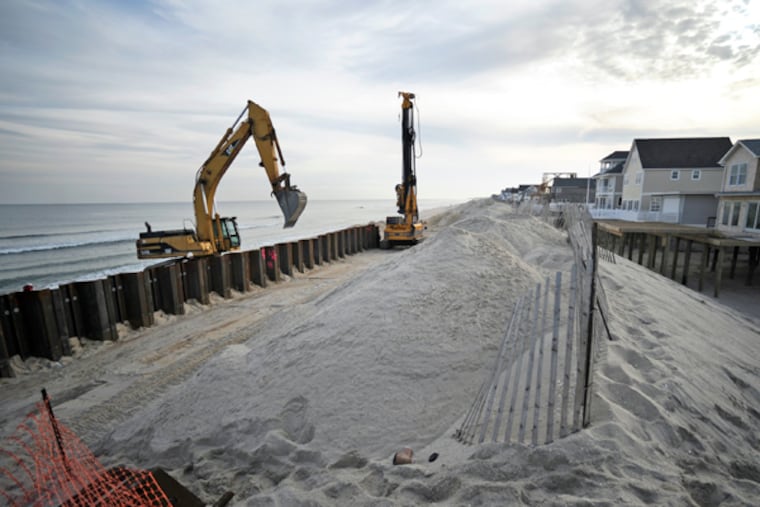
BRICK TOWNSHIP, N.J. - You won't be able to see it when it's finished, because the seawall that extends three and a half miles through two beach towns will be covered in sand and is being rooted 30 feet below sea level.
It will act as an invisible barrier against future storms such as Hurricane Sandy along a stretch of the Jersey Shore that was arguably the most devastated by the October 29, 2012, storm that did $38 billion worth of damage in the state. The new steel seawall lines a beach-ward section of Route 35 and runs through Mantoloking and the Normandy Beach section of Brick Township. It is now more than 70 percent completed and should be finished the end of year, officials said.
The stretch of beachfront, where the road runs parallel, was where Sandy roared ashore and pulled houses off foundations and rolled them out to sea. It is also where some buildings seemed to have been chomped and mangled by a giant predator that left the innards of the structures exposed - cereal boxes still sat in kitchen pantries, curtains on windows flapped in the breeze, and summer dresses still hung in bedroom closets, but the other half of the houses were gone.
So ferocious was the thrust of the storm in the region that it sliced a new inlet through the narrow middle of Mantoloking, where centuries ago there was a narrow waterway called Herring Inlet that was filled in by decades of development.
Severely damaged, too, was Route 35, the only artery that connects a string of Ocean County beach towns. The Federal Highway Administration invested $265 million to rebuild the road and paid 80 percent of the $23.8 million cost of the new seawall. The rest of the funding came from the state Department of Environmental Protection's Shore Protection Fund, said Bob Considine, a spokesman for the DEP.
DEP Commissioner Bob Martin called the seawall project extremely critical to the recovery of the region as the Army Corps of Engineers works to complete a dune system along the length of the northern Barnegat Peninsula.
Considine said that despite a glitch involving what may be the discovery of the shipwreck of a historically significant 19th-century British wooden coal-hauling and passenger vessel, the Ayreshire, the project had been proceeding on schedule.
The 200-foot-long area where a pile driver broke twice as it tried to pound 45-foot-long steel panels into the sand and instead hit the ship's wooden timbers and windlass has been roped off while maritime archeologists determine whether the remains are the Ayreshire. The wreck was notable because it involved the first use of a device known as a life-car, which saved all but one of the Ayershire's 202 passengers and crew.
Considine said that the archeologists' report was expected back in about two weeks, and that officials would determine then how the project would proceed at the spot where the wreckage lies. He said investigators used ground-penetrating radar to establish the boundaries of the wreck. Pieces of the ship exposed by the construction work have been removed and secured at another site, he said.
"But the critical part of the project has been completed," Considine said, noting that the shipwreck site is close to the terminus of the seawall.
The wall's marine-grade steel is expected to last up to 75 years, and crews have used more than 18,000 linear feet of it.
Officials in Mantoloking and Brick Township contended their towns were sitting ducks for storms until the project is complete.
"Right after the storm, there were suggestions that maybe we shouldn't be here at all, that a barrier island is not an appropriate place for permanent habitation," Mantoloking Borough Councilman Steve Gillingham said. "What that notion ignores is that we've had people here for 150 years."
Gillingham acknowledged that without the large dunes that once lined the skinny barrier island where his town and neighboring Normandy Beach are, the towns felt exposed to storms.
So they used front-end loaders to build makeshift dunes along their beachfronts while awaiting the seawall and a $158 million federal dune-rebuilding and beach-replenishment project, which is expected to get underway in March. The project is part of the Army Corps' plan to replenish or repair beaches along New Jersey's entire 127-mile Atlantic coastline. The plan includes renourishing the beaches for 50 years once the project is completed, officials said.