Hermine aims for N.J., Del.; likely to regain hurricane winds by Sunday night
Churning up the Eastern Seaboard, Tropical Storm Hermine is expected to regain Category 1 hurricane-strength winds by Sunday, clobbering the New Jersey and Delaware coasts, causing potentially deadly flooding, and robbing Shore merchants of one of their busiest three-day weekends of the year.
Churning up the Eastern Seaboard, Tropical Storm Hermine is expected to regain Category 1 hurricane-strength winds by Sunday night, clobbering the New Jersey and Delaware coasts, causing potentially deadly flooding, and robbing Shore merchants of one of their busiest three-day weekends of the year.
Weather experts and state and county officials warned of high winds and tidal flooding not seen since the nor'easter in January that smacked much of the shoreline, left dunes flattened and streets flooded for days, if not weeks, and caused power outages throughout the region.
As of 8 a.m. Sunday morning, the National Hurricane Center said maximum sustained winds clocked near 65 mph, shy of the 74 mph needed for Category 1 hurricane status. Hermine is expected to reach that distinction by Sunday night and meander slowly offshore for the next couple of days, which could subject the coast to repeated storm surges.
In Delaware, Gov. Jack Markell issued a similar emergency declaration for Sussex County.
In 2012, when Superstorm Sandy wreaked devastation along the New Jersey and Delaware coasts and elsewhere, it was a Category 1 storm at landfall with a record-breaking storm surge and wind gusts close to 90 mph, according to the National Weather Service.
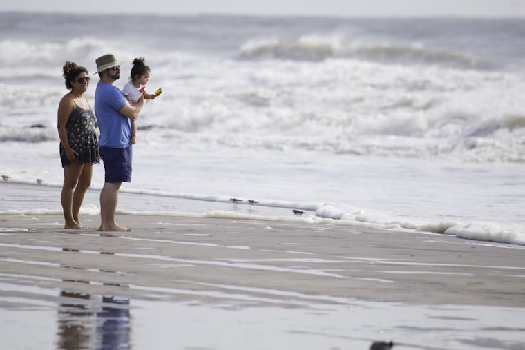
As menacing dark clouds rolled in Saturday, many vacationers jammed roads and highways in long highway queues in a mobile exodus away from Shore points. Atlantic City's mayor, however, urged visitors to defy the storm, to stay and visit casinos and restaurants.
"The greatest impact will occur [Sunday] through Monday," said Jim Eberwine, emergency management coordinator for Absecon, who tracked hurricanes and nor'easters for the National Weather Service in Mount Holly for 40 years. "The storm is still south of us and will intensify and build to a Category 1 hurricane."
Eberwine said the strength of the storm was not New Jersey's biggest worry.
"It's not a case of how strong the storm," he said. "It's a case of how long it will affect the coastal areas, primarily the barrier islands."
He explained that the back bays fill up with successive high tides and then "don't have anywhere to drain, so they get a little higher and the access roads take on water during the high tides," causing flooding.
"Cape May and Atlantic County will probably get major tidal flooding," Eberwine said, "and in some areas, expect to see what we had in January. That was 8½- to 9-feet tides from a real strong nor'easter on Jan. 23. It will be pretty close to that, looking at everything."
'Life-threatening'
The National Hurricane Center warned in its 5 a.m. advisory that an Air Force Reserve Hurricane Hunter aircraft had clocked Hermine's winds with gusts higher than 65 mph. Forecasters said the storm was expected to bring rough surf, rain, and coastal flooding up the Atlantic Seaboard as it churned across open waters.
"Hermine has a large wind field," the advisory said, with tropical storm-force winds extending outward for 205 miles from the center. The storm was centered about 295 miles east-southeast of Ocean City, Md., moving to the east-northeast at 12 mph.
Hermine is expected to produce 1 to 4 inches of rainfall over southern Delaware, southern and eastern New Jersey, and Long Island through Monday morning. The advisory also warned of large waves along the Mid-Atlantic coastline, with "life-threatening surf and rip current conditions and significant beach erosion."
'The big concern'
Hermine roughed up the Outer Banks of North Carolina with top winds of 65 mph, and as it moved to the east-northeast, tropical storm warnings were posted as far north as Massachusetts, with dangerous storm surges expected. The storm was blamed for at least two deaths, damage to homes and businesses, and power outages for hundreds of thousands of people from Florida up the Atlantic coastline.
Forecasters warned that the combination of storm surge and high tides would flood normally dry areas near the coast - and that the surge would be accompanied by "large and dangerous waves."
Christie and Markell were joined by governors along the Atlantic coast announcing emergency preparations.
"The impending weather conditions constitute an imminent hazard which threatens and presently endangers the health, safety and resources of the residents of Ocean County, Atlantic County and Cape May County," Christie said.
Cape May County officials held a conference call Saturday afternoon to discuss the storm and its impact with the county's Office of Emergency Management director, Martin Pagliughi.
"This is pretty serious and we're treating it as such," said Diane Wieland, director of the Cape May County Department of Tourism. "The big concern right now seems to be the flooding."
Pagliughi warned that high tides Sunday night and Monday morning were expected to be the most troublesome, especially in the back bays. He said extensive street flooding was expected during high-tide cycles through Monday.
Motorists were warned not to drive through floodwaters and to move vehicles to higher ground in advance of the high tides.
In Delaware, Markell's order said significant rainfall and wind gusts as high as 50 mph were expected, with "localized flooding along the coast and lower Delaware Bay during high tides on Sunday and Monday."
He authorized the Delaware National Guard to "pre-position its forces in anticipation of the storm's biggest effects" in the state Sunday and Monday.
In New Jersey, where low-lying coastal areas are vulnerable to flooding, there had been no official calls for evacuations, but residents were beginning to take precautions. Swimmers were urged to stay out of ocean waters because of dangerous waves and riptides.
Christie advised that shelters had been designated - but not yet opened - in several locations:
Cape May County: Woodbine Developmental Center, 1175 Dehirsch Ave., and Upper Township Middle School, 525 Perry Rd., both in Woodbine;
Atlantic County: Atlantic City Convention Center, 1 Convention Blvd.; and
Ocean County: Southern Regional High School, 90 Cedar Bridge Rd. in Stafford Township and Pinelands Regional High School, 590 Nugentown Rd., in Little Egg Harbor Township.
Economic losses
Police in Sea Isle City posted a traffic alert advising of "significant delays" leaving the island late Saturday morning. Heavy outbound traffic was also reported on the Garden State Parkway.
Sea Isle City police also said the Townsends Inlet Bridge between Sea Isle City and Avalon was closed because of high water and wave action.
"This is not a beach weekend for anyone in the Mid-Atlantic to the Northeast," said Eric Blake, a hurricane specialist at the National Hurricane Center in Miami.
Hermine threatened to be an economic party crasher for Shore merchants who expected to boost revenues over Labor Day weekend as they head into the school season and the fall. The weekend - along with Memorial Day and Fourth of July - is one of their biggest moneymakers.
In Cape May County, for instance, the winter population is under 95,000, while summer residents swell the population to more than 820,000, Wieland said. With a holiday weekend, the population easily swells to more than a million people, she added.
"It's going to hurt [economically], but that's not the main concern," Wieland said. "It's the safety of lives and property. There are a lot of people down here this weekend."
Morey's Piers - the rides and amusements on the Wildwood Boardwalk - were closed along with the tram car service.
Danny Ferrazzano Jr., whose family owns and operates Hershey's Ice Cream shop in Wildwood, said businesses up and down the boardwalk were gearing up for the storm. They enjoyed the customers they got Saturday, knowing that Sunday and Monday would not bring in the crowds like those usually generated by Labor Day weekend at the Shore.
"Believe it or not, though, people are out and walking around the boardwalk," Ferrazzano said just before 6 p.m., as rays of sun peeked through. "As long as it's not raining and things are dry, there is foot traffic. Some folks who own houses here have left, but there are still a lot of brave vacationers on the island eager to leave their hotels and looking for things to do. They didn't come down to sit in."
Still, Ferrazzano said his shop ordered less ice cream than a normal holiday weekend in anticipation of the storm. It also has a generator on standby in case of power loss.
In Atlantic City, officials canceled the weekend's Live Nation beach concerts by Florida Georgia Line on Saturday and Blink-182 on Monday.
But Mayor Guardian said in a statement that Atlantic City's casinos and restaurants would be open for business and he invited Labor Day vacationers "to come on down to Atlantic City early Saturday and ride out the storm inside one of our luxurious casinos or hotels."
At 6 p.m., the view inside the Borgata, in the city's Marina District, was that of a busy gaming floor and packed restaurants.
"The property is very busy, being it is not a day to be outside," said Joe Lupo, Borgata's senior vice president of operations. "Today is expected to be very busy."
To aid residents of the beleaguered city, Atlantic City opened its Casino Reinvestment Development Authority Wave parking garage for free parking for those who live in low-lying areas in the city whose cars could be flooded by a storm surge.
215-854-4184@SuzParmley
This article contains information from the Associated Press.