Power outages, surprise snow, stuck trains, canceled planes. And a dash of luck
The litany of mayhem makes this most disruptive storm of the season.
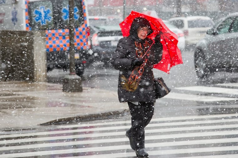
More than 250,000 homes and businesses lost power; ocean-inciting winds gusted past 70 mph, and a surprise near-horizontal snowfall did a decent impersonation of confetti in a food processor.
The litany of mayhem Friday was unrivaled by any other storm this season: Downed trees; canceled SEPTA and Amtrak trains; over 540 flights canceled; westbound lanes of the Schuylkill Expressway shut down; Valley Forge National Historical Park roads closed by falling trees; numerous accidents.
>>CLEANING UP: Why it takes Peco so long to restore your power after a storm
>>MORE TO COME: Second nor'easter en route as region still recovers from last week's storm
With sustained winds up to 35 mph, and gusts past 60, the snow reduced visibility to blizzard-like levels and slicked some area roads with slush, all the result of a meteorological "bomb" whose fallout was felt by tens of millions of East Coast residents.
From 2 to 4 inches — in some places up to 9 inches — of heavy, wet snow in the region helped drive the prodigious power-outage numbers, which were expected to continue to climb through the night and perhaps into tomorrow.
"We see widespread extensive damage throughout the area," said Peco spokeswoman Liz Williamson.
And in the evening, Gov. Wolf activated the National Guard to support local authorities' response to the storm.
Yet for all that, nature also bestowed a measure of luck on Friday.
The New Jersey Shore caught somewhat of a break, and the snow had one positive impact, said Joe Miketta, the acting meteorologist in charge of the National Weather Service office in Mount Holly. The changeover all but shut off the inland flood threat. By late afternoon, winter weather advisories had replaced flood watches.
In effect, the storm's very strength compromised the flood threat. It intensified so rapidly off the Atlantic coast that it qualified as a meteorological "bomb," said Jim Hayes, a meteorologist at the Weather Prediction Center, outside Washington, and a veteran of the Mount Holly office. "It was like a shock wave."
The powerful north winds, part of the counter-clockwise circulation around the storm center, imported cold air that arrived more rapidly and robustly than forecast.
The recent mild spell in the East notwithstanding — last month was one of the warmest Februaries on record — the atmosphere remembered it was winter. The changeover to snow occurred in the Philadelphia region with abandon around mid-morning — to the surprise of computer models and the humans who rely on them. The snow got all the way to the Shore.
"Our mesoscale models can indicate where it might happen," said Hayes. "I don't think that we have the ability to nail it down."
"With all these nor'easters, it's hard to pinpoint what's precisely going to happen," Miketta said. "It's a nor'easter. You're going to get some nasty stuff."
At the Shore, it was indeed nasty, but again some good fortune blew its way. The winds howled from the north rather than the northeast, and although moderate flooding still was possible Saturday morning, onshore winds would have been far more damaging to the beaches.
The weather might not have been as bad as some expected, but it nonetheless made conditions more difficult for firefighters in Ventnor, called to climb onto the roof of a burning home at Atlantic and Roxborough Avenues. One firefighter reportedly was hospitalized.
The north winds blew the snow horizontally, rattled stop signs, and whipped the water frothy, but most at the Shore were thankful it stopped there. Shore Road, just off Route 30, was closed in front of Brenda Ruppert's Absecon home, perched on a hill. Water had flooded the street, forcing police to block it. A large pickup truck churned through nearby, almost getting stuck as the water reached the running boards.
"This is nothing," said Ruppert, smiling. "This is a baby." Well, maybe not a baby; a wind gust of 71 mph was reported in Cape May County.
Overall, the Shore largely escaped the destruction of past storms. The National Weather Service was advising that minor flooding would occur, escalating to moderate flooding with high tide Saturday morning. "We're still looking for tomorrow's high tide to be the most problematic," Miketta said Friday.
Throughout the region, persistent high winds on Saturday could complicate the cleanup, which might become a moving target.
"A lot of trees are down everywhere," said Brad Rudolph, a spokesman for PennDot. "I expect that to continue through the day tomorrow."
The travel headaches for motorists on Friday had more to do with the dangerously low visibilities and downed trees and branches than the road conditions, Rudolph said.
After trees fell across the roadway, including one that landed on the roof of a SEPTA bus around 1:10 p.m., the Schuylkill Expressway westbound lanes were closed for more than three hours in the vicinity of Lower Merion Township. SEPTA said 15 passengers were on the Route 125 bus. Four minor injuries were reported.
SEPTA temporarily suspended service on all Regional Rail lines, and the delays left hordes of stranded commuters at the city's major transit hubs. Amtrak suspended service along the Northeast Corridor until Saturday. And for those who wanted to get away from it all, Philadelphia International Airport was not the place to be. More than 540 departing or incoming flights had been canceled by midday, according to airport officials.
The atmospheric trouble-maker had been well forecast, with meteorologists warning early in the week of the potential for a potent coastal storm and even hinting at the possibility of wet snow mixing in.
But the computer models whiffed on the arrival of the cold air, a dramatic development given that temperatures in Philadelphia on Thursday approached 60. Hayes said the models did better with the snow forecasts in the mountains — up to 35 inches fell in the Catskills.
Around here? "What's happened from the Lehigh Valley to northern Delaware wasn't modeled all that well," he said. "I think we all know that these kind of things can happen."
In the end, however, things could have been worse, as the region was spared major flooding.
In terms of that luck, said Miketta, "We'll take whatever we can get."

