First in an occasional series.
ABOVE THE NORTH PACIFIC - Eight miles up, in a mysterious region where the atmosphere harbors some of its most dangerous secrets, Cmdr. Jeff Hagan was taking in the ironies aboard a Gulfstream IV jet.
The mesmerizing view of a dense cloud mass outside the cockpit window on Thursday suggested an endless white beach and a sky-blue sea. But Hagan knew such a calm was illusory. Behind the clouds were violent winds taking aim at the United States.
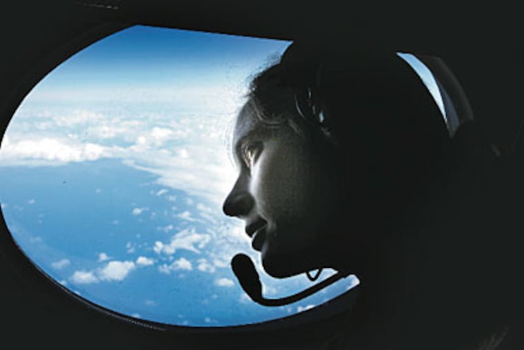
The in-flight meteorologist, Willow Grove native Jessica Williams, was analyzing data that help fuel the world's weather forecasts. She and the Gulfstream crew were hurtling over nature's storm factory, home to the winds that have brewed a winter of floods in California and the Philadelphia region's record snows. Jet-stream winds even had a hand in this weekend's heavy rains.
Solving the jet stream's riddles could immensely improve short-term and long-term forecasts, yielding economic benefits and giving power companies and emergency managers a heads-up on major storms. It would be a boon to airline safety. Scientists see the jet stream, too, as a bellwether for gauging the future course of Earth's climate.
"If you want to understand the creating, development, and translation of winter storms, you have to understand jet flow," said Louis Uccellini, the director of the National Centers for Environmental Prediction.
But here above the North Pacific, that flow is in a blind spot, so far from land and traditional weather-tracking tools that it can be mined only by Williams and the crew on the plane.
"This," she said, "is a weather nerd's dream job."
Aboard the high-altitude jet, she and the rest of the National Oceanic and Atmospheric Administration (NOAA) crew, clad in blue jumpsuits with "Hurricane Hunter" patches, were looking for trouble.
From a rear hatch, they were dropping data "bombs" - miniature weather stations no bigger than an extra-large hoagie roll, packed with instruments that record what is going on as they float down, slowed by "square-cone" parachutes, through chaotic air to the agitated, whitecapped sea. One of the probes dropped on Thursday measured a wind speed of 161 m.p.h.
Hagan, a former Coast Guard pilot who lives in Tampa, Fla., mused that he had been trained to avoid bad weather. That changed when he joined NOAA 16 years ago.
"You go to NOAA, and they tell us to fly through it," he said. "It's kind of ironic."
Hagan, who flew into every hurricane in the stormy years of 2004 and 2005 - including six trips into Katrina - now is flying missions for the Winter Storm Reconnaissance program.
This $875,000 project's aim is to relay data that can't be captured any other way. Since January, the jet has dropped 492 instrument packs into the Pacific on flights from Tokyo, Honolulu, and Anchorage, said project manager Nancy Ash. For the next several days, the data from the "bombs" dropped on Thursday will be used in computer models all over the world for weather forecasts.
And in the longer term, that data will help researchers come to a deeper understanding of the powerful jet-stream winds that are crucial to the weather out here, in Philadelphia, and all over the world.
The potent winds form over the clashing boundaries of warm and cold, inciting storms and moving them around the planet.
These are the powerful winds, noticed by a Japanese researcher in the 1920s, that bedeviled World War II bomber pilots, causing their planes over Europe and the Pacific to burn precious fuel and their bombs to miss targets, and contributed to a horrifying incident in the woods of Oregon.
The winds have been particularly ferocious this winter, with the unusually warm El Niño waters over the tropical Pacific simmering the overlying air and sharpening the temperature contrasts.
Aboard the Gulfstream IV, engineer Charles Lynch was dropping the instrument "bombs" from an airtight hatch in the rear of the craft. They were thin cylinders, about 18 inches long, encapsulating a computer board. Brief gasps of air went through the cabin as Lynch opened the hatch and ejected the devices called dropsondes.
They work like upside-down weather balloons, reading wind, pressure, and temperature from the top down, rather than the bottom up. A tiny square parachute slows the descent, said technician Mark Rogers.
The dropsonde sends back readings every half-second during its 13-minute descent to the waves.
The Gulfstream was stalking a deep upper-air system behind a cold front the shape of a dragon's tail about to lash the West Coast. The cylinders had wild and erratic rides through the layers of winds, as so many of those World War II bombs must have had.
The dropsonde data were relayed to in-flight meteorologist Williams, an Upper Moreland High School alumna, who screened them for "outlier" readings that would skew the data that were about to be sent to the rest of the world via satellite. Unusual jumps in air pressure and temperatures might indicate a problem with the transmitter.
Williams' love of weather science goes back. She remembers when, as a lifeguard at the Upper Moreland Swim Club, she would pass the tedious hours admiring the reflected clouds floating across the pool.
Thursday's first "bomb" turned out to be a dud, failing to relay any signals. But the next 16 sent back portraits of an atmosphere in a frenzy.
The tumult was over a teardrop-shaped region with its apex 1,600 miles northeast of Honolulu. One of the probes sent back a wind reading of about 50 m.p.h. on the surface of the Pacific, so fomented that Williams and the others could see whitecaps from 45,000 feet.
On this day, this was the National Weather Service's "feature of interest" - a region where trouble was brewing and where the computer models couldn't quite agree on exactly what was going on.
A few days earlier, in suburban Washington at the center Uccellini runs, scientist Yucheng Song had identified this as the target area. Song, who serves as chief advance scout for the project, sent word to Honolulu. Paul Flaherty, another NOAA project manager, alerted the crew.
They don't chase every fledgling storm. Flaherty pointed out that it is impractical, not to mention costly, to conduct saturation data-bombing raids on an area as vast as the North Pacific, so budget-conscious NOAA tries to pick its spots.
The data collected are almost instantly available around the world, posted on the National Hurricane Center Web site. They also become key pieces of information fed to computers every 12 hours to generate forecasts.
Computer models have revolutionized forecasting by taking the "initial" state of the atmosphere, comparing it to previous states, and then calculating how the atmosphere will change in the coming hours and days.
Those models have a fundamental weakness, however. The observations are weak when it comes to the vertical structure of the atmosphere. Weather balloons are sent up twice daily from land stations all over the world to profile the air. However, observations in the Southern Hemisphere and over the oceans are sparse.
Satellites give the big picture and are a huge help in filling some of the gaps, but they are no substitute for direct observation, said meteorologist Thomas Reichler of the University of Utah.
"No satellite can get the data you get with a dropsonde," said NOAA Lt. Cmdr. Kristine Twining, who, like Hagan, belongs to the NOAA Corps, a branch of the military. The Gulfstream is also a hurricane-reconnaissance craft.
Given that the jet's dropsonde observations are included with the results of the balloon soundings, it is hard to pinpoint the full extent of their impact on weather-forecast accuracy, Flaherty said.
Even so, he said, various analyses have shown that in 85 percent of the cases, the dropsondes improved predictions.
Forecasts will still contain their share of errors, said Williams, a Penn State graduate, "but they're going to be much smaller."
The nearly two-foot snow that hit Philadelphia just before Christmas helps explain the value of the "bombs." That storm, Uccellini noted, wasn't picked up by the computer models until the "feature" that set it off was captured by balloon soundings over land. Thus, the magnitude of the storm didn't become clear until two days before it hit Philadelphia.
By contrast, the early February two-footer was picked up well in advance - by models that included data from the dropsondes. In its early stages, that storm was monitored by a NOAA reconnaissance flight out of Tokyo on Jan. 31.
The weather system that the NOAA crew was shadowing Thursday was expected to make its way to the Gulf of Mexico and all the way to Florida, affecting Philadelphia indirectly. The crew's next target is a system that could affect the region late this week, said Uccellini, who is the National Weather Service's minister of mayhem - hurricanes, tornadoes, blizzards, and the like.
Indeed, the burgeoning Pacific storm that Williams and her crewmates "bombed" was another in a relentless sequence that has tormented the nation all winter.
In the longer term, Uccellini said, the data from the dropsondes will help meteorologists come to a deeper understanding of the jet-stream winds.
Generally, they blow west to east, in snakelike patterns around the world, as high as nine miles above the surface. They are three-dimensional systems that vary in width, from 50 to 200 miles, and depth.
Williams said the probes measured one jet-stream wind that was five miles in depth.
The winds get their name from the focused jets of air - not from aircraft.
Although it is often called the jet "stream," it is not a singular entity but part of a complex global system. The upper-air map Thursday showed three branches - the polar, northern, and southern - over the Pacific. Occasionally, the torrents of air merge, and in winter, that's going to mean a blizzard.
The winds were first described by Japanese meteorologist Wasaburo Ooishi, whose findings were largely ignored by the Western world.
During World War II, the Japanese were well aware of the jet stream, and used the currents to send incendiary balloon bombs to the United States. One of them exploded in Oregon during a Sunday school picnic, killing a woman and five children.
They were the only World War II casualties inflicted by enemy attack on the U.S. mainland.
Scientists are still building on the work that Ooishi began. Reichler's research, for example, has found evidence that jet-stream winds are slowly shifting northward as the planet warms subtly. Such a shift could have profound long-term consequences - such as changes in locations of deserts and rain belts.
Williams and the NOAA reconnaissance crew have a more immediate concern. They're probably donning their blue jumpsuits with the "Hurricane Hunter" patches even as you read.
That's because more trouble is brewing over the North Pacific. Song has spotted another "feature of interest": a system that could spawn yet another East Coast nor'easter this week that would blow up over the warm waters of the Gulf Stream, one of the jet stream's favorite coconspirators.
While the forecast may look benign now, the National Weather Service in Mount Holly cautioned that the storm "will still need to be watched."
Today, Williams and the crew will be back up over the North Pacific, doing just that.
To see a video and a gallery of photos from aboard the reconnaissance jet, go to http://go.philly.com/jetstreamEndText