Erin set to stir up the already-rough Jersey surf and enhance coastal flooding
Wildwood has banned ocean swimming for the week. A flood advisory is up for the Shore.
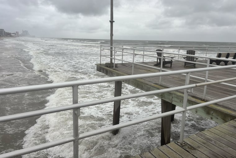
The surf already is in a state of agitation at the Jersey Shore with Hurricane Erin still a very remote threat, and in all likelihood the rip-current warnings and coastal-flood advisories will be spending much of the week with the beach-town residents and visitors.
This is not quite what the local chambers of commerce had in mind for a peak vacation period before kids report back to schools.
“It’s a shame,” said Erich Becker, chief of operations with the Ocean City Beach Patrol.
A coastal flood advisory is in effect for towns from Ocean City to Cape May Point and for the Delaware beaches from 4 to 10 p.m. Tuesday, with some road closures possible, the National Weather Service says.
The sun is due to return throughout the region Wednesday, and while the ocean waters have been invitingly warm — the surf off Atlantic City reached 81.5 degrees Sunday — they will be in a hazardous state.
“We do have beaches open, but we’re keeping everybody ankle-deep,” Becker said.
Citing “extremely dangerous” conditions, Wildwood has announced that the ocean will be off-limits to swimmers and bathers the rest of the week.
And those conditions at the Shore aren’t going to get better this week as Erin proceeds north.
Erin’s impacts on the Jersey Shore
At 2 p.m. Tuesday, the center of Erin — with peak winds of 105 mph — was about 950 miles south-southeast of the Jersey Shore, according to the National Hurricane Center, and was creeping northward at 7 mph.
Erin isn’t the primary factor in generating rip currents on Jersey beaches — just yet.
“Certainly, Erin is not helping,” said Mike Lee, a weather service meteorologist in Mount Holly. But the surf on Monday was being stirred primarily by strong onshore winds, gusting up to 35 mph, behind a front that came through Sunday night and triggered surprising downpours in parts of the region.
The office’s rain gauge captured 4.84 inches, the fifth-highest daily total since it moved there in 1993. A weather service employee five miles away measured 5 inches as thunderstorms stalled in an area from southeastern Montgomery County to eastern Burlington County.
The front was pushed south by an area of higher pressure, or heavier air, that has interacted with lower pressure, lighter air, to the south.
Those winds likely will pick up as Erin tracks north between the East Coast and Bermuda later in the week and the pressure differences increase, Lee said.
The storm is not expected to get closer than 450 miles from the Jersey Shore, but it isn’t out of the question that tropical-storm force gusts, those of 39 mph or higher, occur near the Jersey coasts.
The weather service says breaking waves of up to 8 feet are possible Thursday, with offshore sea heights up to 15 feet possible.
Coastal flooding will persist, even without rain
The weather service’s advisory for nuisance flooding is in effect from 4 until 11 p.m., with back-bay flooding and road closures possible.
Again, that’s wind — not Erin.
During the week, however, the waning moon and Erin’s passage may be factors in the flood threat.
In addition to foaming up the surf, the steady onshore wind “just pushes up ocean water in the back-bay area, all the way back,“ Becker said.
Back-bay flooding in Shore towns is more common than on the oceanfront.
“The streets along the ocean always seem to be the driest,” Becker said, “the opposite of what you think.”
As for the businesses on Ocean City’s well-trodden boardwalk and the town’s other diversions, the ocean conditions may even be a boon for them and vacationers, Becker said.
“That’s the positive.”
Staff writer Amy S. Rosenberg contributed to this article.
