Flood watch, wind wind warnings for 60-mph gusts: A dreary, blustery April to exit with a flourish
Downpours are likely late Thursday, but the weekend looks decent. And don't ask about next week.
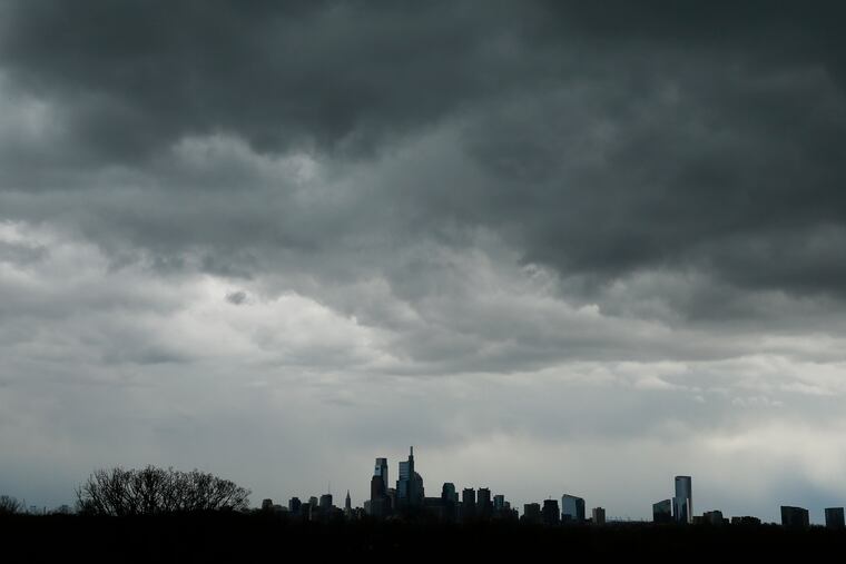
April somehow lost its way around the middle of the month, and since then it has pulled off a convincing impersonation of March. And forecasters say that fittingly, it’s about to bow out like a March lion, with roaring winds and drenching rains.
A flood watch has been posted for the entire region from 2 p.m. Thursday through 2 p.m. Friday, with the Schuylkill and area streams possibly approaching flood levels, along with a wind warning for gusts up to 60 mph until 8 p.m. Thursday.
Philadelphia can expect about 2 inches of rain from a complicated storm pressing from the west, said Patrick O’Hara, a meteorologist at the National Weather Service Office in Mount Holly.
This time of year, the lush foliage will absorb quite a bit of that water, but the concern is that the bulk of it will come in a relatively compressed period Thursday into the night, O’Hara said.
» READ MORE: Philly’s gloomy weather has been matching the national mood. And it might be about to get worse.
“This one is going to pull moisture all the way from the tropics,” said Jack Boston, a meteorologist with AccuWeather Inc. “Winds are lined up from the surface up to 18,000-to 20,000 feet. It’s just going to be a real gush of moisture coming up.”
In addition, 3 inches could fall in the Poconos, and heavy rains upstream could push the rivers toward bank-full, even after the rain stops and the waterways in the area turn to mocha from all the runoff.
The Schuylkill is forecast to crest at or near minor flood stage on Friday at Norristown and the cautionary “action” level in Philadelphia; the Delaware at Trenton could rise to near the action level on Saturday.
However, road-ponding and spillovers from the region’s friskier creeks would be more likely than any river flooding, Boston said.
While this has been quite the wild weather month, with gusts of 25 mph or better occurring on 18 days, and 50 mph-plus on three of those, April through Wednesday had one perhaps-surprising claim to normality.
The 3.41 inches of rain were a dead-on match for the long-term average. That is about to change, of course.
The temperature flip, however, has been exceptional for its tenacity: Tuesday marked the 15th-consecutive day of below-normal readings in Philadelphia, the longest streak since November 2018.
The region has been caught in a corridor of chilly air between cold, high pressure in northwestern Canada and a pressure pattern over the North Atlantic Ocean that favors chilly air pouring into the Northeast.
» READ MORE: Philly-area public gardens are losing their peak season, and the ‘bloom of the decade,’ to the coronavirus
As a result, the average temperature from April 14 through Tuesday, 48.9 degrees, matched the average temperature for March.
The plus in all this is that there’s a 100% chance that April is about to end, and Saturday and Sunday are looking decent, with temperatures Saturday in the mid- to upper-60s, or close to normal, and well into the 70s on Sunday.
Don’t get used to it, Boston said. Readings are due to head south again starting about Tuesday and could be 5 to 10 degrees below normal throughout next week.
Looking further ahead, don’t be surprised if a surge of heat comes the second half of May, he said. In short, May could be the reverse of April.
“It’s going to be a topsy-turvy month,” he said.
