Drought-easing downpours and wind gusts up to 55 mph are possible Wednesday and Thursday
The storm could become a "bomb cyclone," and winds could gust to 55 mph on Thursday, perhaps higher at the Shore.
They will not eliminate the precipitation deficits locally and elsewhere in the Northeast, but the Philadelphia region evidently is about to get a generous soaking starting Tuesday night and fresh rounds of potentially damaging winds Wednesday and Thursday.
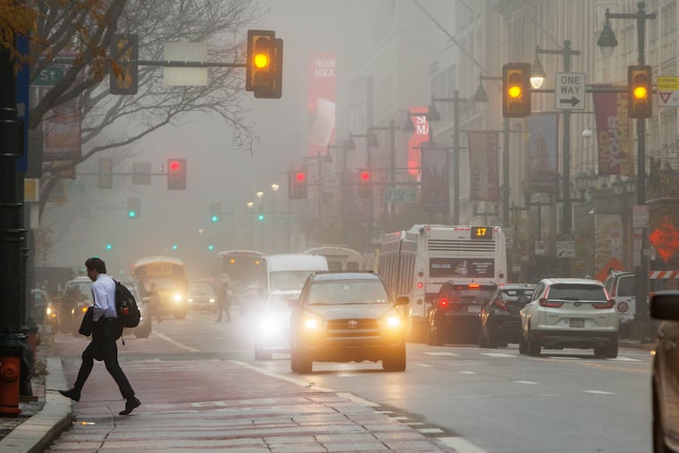
A potent storm that eventually may mutate into a “bomb cyclone” on Wednesday is expected to wring out 2 to 3 inches of rain around here, along with potential thunderstorms.
This would come a week after winds were suspected of contributing to at least two deaths in the region and resulted in more than 40,000 power outages. Similar gusts could occur Thursday after a front crashes through the region and the rain shut off, said Bob Larsen, senior meteorologist with AccuWeather Inc.
Drought advisories remain posted in Pennsylvania, New Jersey, and Delaware, and those almost certainly will survive the week.
But as of Monday, the so-called salt line, the DMZ between fresh and seawater that could contaminate drinking-water supplies, had retreated to near the City of Chester, 3.2 miles south of where it was last week, said Kate Schmidt, spokesperson with the Delaware River Basin Commission.
It likely will undergo a further flushing later this week as the rains will be basin-wide.
“It’s going to be a good soaker,” said Mike Lee, a meteorologist with the weather service office in Mount Holly. “We’re still in quite the deficit, but this will be welcome rain for sure.”
How significant are the rain deficits in the Philadelphia region?
Philadelphia and the neighboring areas in the surrounding counties and all of South Jersey are experiencing “extreme drought” conditions, according to the inter-agency U.S. Drought Monitor. The rest of the region is in “severe drought.”
Through Sunday, rainfall in the region was merely 25% to 30% of normal in the previous 90 days, says the weather service’s Middle Atlantic River Forecast Center, which uses a sampling of measuring stations in each county.
Philadelphia’s was more than 8 inches below normal.
Droughts tend to take their good old time ending, but upper-air-patterns that had shut off moisture from the Gulf of Mexico to the Northeast have undergone significant changes, Larsen said. NOAA’s Climate Prediction Center favors normal temperatures and precipitation for the Philadelphia region in the Dec. 17-22 period.
What are Philly’s chances of seeing snow in the near future?
It’s not out of the question that some places north and west of the city see some snowflakes before the precipitation shuts off early Thursday and cold air returns. However, that is a long shot.
As is so often the case in Philly winters, cold and precipitation have an approach-avoidance relationship, mostly avoidance in recent years.
“We just came out of a 10-day period of persistent cold and no major storms,” said Larsen, “and now, voila, we’ve got a major storm on the way and cold air is nowhere to be found.”
This storm, which may intensify sufficiently to meet the meteorological criterion for a “bomb cyclone,” he said, will pass west of the region as it barrels into Canada. Areas to the east of storm centers experience counterclockwise warming winds from the south.
Philly’s major snows are generated by coastal storms to the east, putting Philly on the cold side of the wind circulation.
Typically, storms around here tend to arrive as cold air retreats, and then get suppressed by the colder, dry air. But once in awhile, it happens that the cold and precipitation do agree to meet in Philly, sometimes even around this time of year.
‘Tis the season when meteorologists experience a significant uptick in that question. Larsen said a flurry of interest broke out last week when it turned cold.
Given the chaos of the atmosphere, it would be unwise to take any forecast seriously more than two weeks in advance, especially in matters of snow.
The region was prodigiously snow-covered on Dec. 25, 2009, after more than two feet of snow fell atop the region during a solstice mega-storm. A foot accumulated on Dec. 24-25, 1966.
But for the record, the smart money would bet against it happening. According to the National Centers for Environmental Information, Philadelphia’s chances of having measurable snow on the ground on Dec. 25 is less than 10%.
