Jersey Shore’s damaging winds were likely the work of a ‘gravity wave.’ Here’s what that means.
Gale-force gusts up to 82 mph hit the Shore during a siege of winds throughout the Philadelphia region.
Hurricane-force winds were roaring at 100-plus mph, 2,000 to 3,000 feet above the ground.
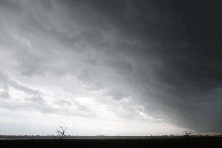
And it is all but certain that a “gravity wave” yanked some of that ferocious energy to the surface, setting off gusts as high as 82 mph on Monday, ripping down power lines; shearing a chunk of roof off the historic Congress Hall hotel in Cape May; and damaging Wildwood’s boardwalk.
“We’re pretty confident it was a gravity wave,” said Robert Deal, a lead meteorologist at the National Weather Service Office in Mount Holly.
» READ MORE: Power outages, roof and boardwalk damage accompany storms throughout Philadelphia region
The damaging gusts were fitting exclamation points to a remarkable five-day wind siege across the region. Jim Eberwine, a longtime weather service marine forecaster and now emergency services director in Absecon, N.J., said he expected a post-storm analysis would show that the peak of Monday’s mayhem was the work of a gravity wave.
So just what is a gravity wave?
In the atmosphere, a gas that behaves like a fluid, waves can move sideways or vertically. A gravity wave is an example of the latter.
Although the appreciation of their impacts on weather is a relatively recent development, they actually occur quite frequently and are visible in certain cloud formations. Under the right (or wrong) circumstances, however, as was the case Monday, they can conspire to cause destruction.
Warm air rises over cold air, and it can climb rapidly during strong thunderstorm outbreaks or other disturbances. A gravity wave results when a parcel of air encounters the resistance of a cooler layer, ultimately forcing the air to descend, bringing strong winds down with it.
On Monday, said the weather service’s Deal, "we saw that the winds were strong aloft, and it was just a matter of how much would reach the surface.”
The answers were evident at Island Beach State Park, where a gust of 82 mph was recorded around noon. And around Atlantic City, a peak wind of 72 mph was measured at the airport, and gusts ripped sheet metal from the side of the former Trump Plaza.
Gravity waves can be both the cause and result of thunderstorms, said Louis W. Uccellini, director of the National Weather Service, who has conducted pioneering research on the phenomenon.
They also can be associated with winter storms, he said, creating corridors of profoundly heavy snows and strong winds.
One example is the East Coast blizzard of 1983. In Northeastern Snowstorms, Vol. I, which Uccellini coauthored with Paul Kocin, the authors noted that a gravity wave on Feb. 11 generated snowfalls at the rates of two to five inches an hour from Washington to New York. Commuters were stranded in the Lincoln Tunnel for several hours by the rapidly falling snow.
Are they a new phenomena?
No. They probably have been around as long as the atmosphere has been making mischief.
However, serious research on how gravity waves might affect weather is a modern development. Uccellini recalled that he discussed them in his first published paper, in 1975.
He found that they could propagate for 1,000 miles, along perhaps a 100-mile-wide alley, and last from two to four hours.
His conclusions were met with skepticism by some of the brightest minds in atmospheric research, who argued that the waves couldn’t last for more than about 20 minutes. They included Theodore Fujita of the Fujita tornado scale.
Uccellini said he became part of a “gravity wave underground.” He added, “We didn’t want to tell anybody we were studying gravity waves.”
The skeptics eventually relented, and the significance of gravity waves to weather events became widely accepted in the 1980s.
Are they predictable?
As with almost everything else in weather, not entirely, although meteorologists have made progress.
In its morning discussion Monday, the Mount Holly weather office said, “We’ve seen all the signatures of a gravity wave propagating through the mid-Atlantic," and thus issued a special weather statement.
“It’s a challenging forecast,” said Deal.
“It would have been nice to know at what point would those strong winds descend,” said Eberwine. “You know it’s coming, but when?”
The gravity wave wasn’t the only force behind a seemingly relentless spell of wind that began Thursday. Atlantic City International Airport, 10 miles northwest of the city and well away from the water, recorded gale-force gusts or better on all five days.
Not that Philadelphia and the surrounding counties enjoyed gentle breezes; 50 mph-plus gusts were common.
No encores are in the forecast, but more rain is due Tuesday night into Wednesday, and just for a dash of icing, parts of the region are under a frost advisory Wednesday morning.
Staff writer Amy S. Rosenberg contributed to this article.