Snow arrives in Philly (again), rare blizzard conditions expected into Monday
The storm may have the intensity of a Category 1 hurricane and become a "bomb cyclone."
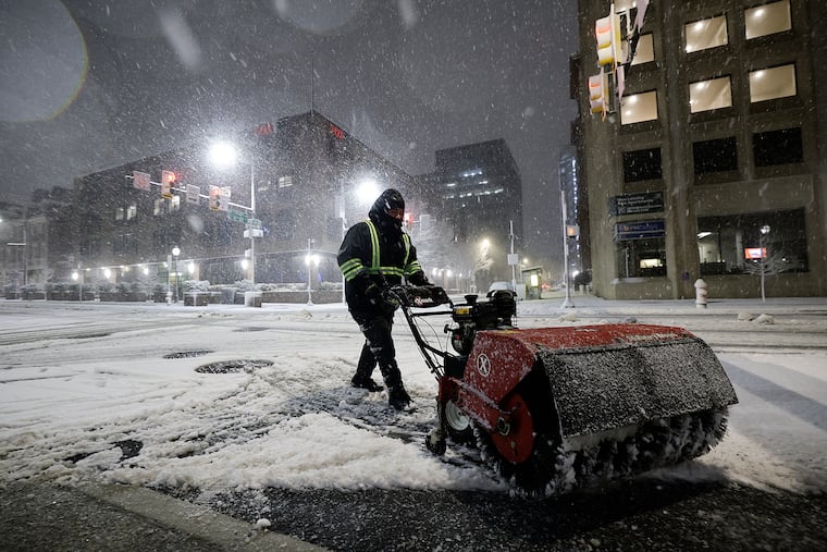
Before a single wet flake was sighted in the Philly region late Sunday afternoon, what forecasters warned would be a storm of rare severity already was having impacts on the workweek.
A blizzard warning remained in effect for Philadelphia and all of New Jersey and Delaware until 6 p.m. Monday. And while snow amounts might not qualify as “historic,” by the time it stops Monday this was expected to be the heftiest snowfall in a decade, with accumulation estimates of one to two feet.
Philadelphia hasn’t experienced a verified blizzard in 33 years, and this one would be powered by a “bomb cyclone” storm whose intensity would be similar to that of Category 1 hurricane, meteorologists said. This marked the first time ever that the entire state of New Jersey was under a blizzard warning, said Judah Cohen, a research scientist with the Massachusetts Institute of Technology.
With heavy, wet snow at the onset, and gusts howling to 45 mph on the mainland during the night — up to 55 at Shore — thousands of homes in Southern and Central New Jersey were without power Sunday night. Plus, with drier snow expected later as temperatures fall below freezing, the region may see something it hasn’t in several winters: considerable drifting.
By the time the plows are done this week, the region could end up with a mini-version of the White Mountains.
In addition to heavy snows, a nor’easter that was ripening off the Virginia coast Sunday was destined to generate potent onshore winds setting off moderate flooding along the New Jersey and Delaware coasts.
The governors of Pennsylvania, New Jersey, and Delaware declared states of emergency and advised against driving.
Schools announced preemptive plans for closings or virtual learning. SEPTA suspended all bus service and warned that Monday might be a mess. PATCO said it would continue on its snow schedule Monday, Amtrak suspended its Keystone Service from Harrisburg to Philadelphia, and NJ Transit announced it was suspending service as of 6 p.m. Sunday. Philadelphia opened extra warming centers that would be available through Tuesday.
About two-thirds of the 1,460 flights scheduled into and out of Philadelphia International Airport for Sunday and Monday had been canceled by 5 p.m. Sunday.
Although the forecast updates later on Sunday were trimmed back from what the weather service said might be “potentially historic” amounts, meteorologists suggested that the conditions would warrant the region’s precautions.
The weather service’s updated predictions called for 12 to 18 inches, with up to two feet in South Jersey. AccuWeather Inc. was going with 10 to 14 inches.
“That’s nothing to sneeze at,” said Tom Kines, senior meteorologist with AccuWeather.
The weather service projections might have been “a little bit high,” said Ray Martin, a lead meteorologist in the Mount Holly office, but, “We don’t want people to be under-warned, that’s for sure.”
The storm almost certainly will reach “bomb cyclone” status, said Cody Snell, meteorologist at the Weather Prediction Center in College Park, Md.
“It will very easily qualify,” he said. The criteria is related to drops in the central barometric pressure. In layman’s terms, a bomb is one heck of a storm.
The storm got off to an uneventful start in the region with light rain falling into early Sunday afternoon with temperatures well above freezing.
But the changeover finally got underway late in the afternoon from south to north. Amounts of 1 to 5 inches were reported around the region by Sunday evening. Officially 1.7 inches had landed at Philadelphia International Airport, as of 7 p.m. Forecasters said snow could accumulate two inches an hour during the night.
Amounts likely will vary as a result of “banding,” narrow, moving corridors where snow falls heavily, said Nick Guzzo, a Mount Holly meteorologist. Banding already was evident early Sunday evening, he said.
And didn’t we just get rid of a bunch of this stuff?
Yes, that 9.3 inches of snow and white ice that fell on Jan. 25 is survived by some debris-strewn graying and blackening mountains, but it’s otherwise gone.
It just took about three weeks.
This one shouldn’t be as tenacious, as it won’t be infused with ice balls, and it will have a tough fight with the increasing power of the February sun.
In the short term, however, it is likely to be quite obstructive.
Accumulations are likely to vary substantially. Narrow corridors of heavier snow were likely to form during the night, and areas under the bands are going to receive the highest amounts.
This also will be a “long duration” storm with its effects continuing well into Monday afternoon. Some snow could continue through the day, the weather service says.
Some folks were determined to mine the best of the situation imposed by nature.
Bartender Bill Coburn at Les & Doreen’s Happy Tap said it was a “snowload,” in which people seek refuge from the blizzard at local bars.
“I think it comes from when you’re a kid — you have a snow day and you all go out somewhere, go sledding,” said James Brenner, 43, who lives above Atlantis: The Lost Bar in Kensington. “It’s just an adult version of that.”
In Germantown, Ashley Ellis Gitongu, 33, brought her three boys to the grocery store to buy some strawberries, a final outing before the impending storm.
With another child on the way, Gitongu was dealing with it all with a certain equanimity. “I’m not too worried, but we are going to be stuck inside for two days,” Gitongu said. And it looks like they’ll be getting some exercise.
“All the furniture is out of the way in the living room so they can play soccer inside,” she said. “We have softballs, Legos, anything to keep them active and distracted.”
Among those not traumatized by it all was Eric Dobson, 57.
“These kind of winters were common when I was a kid,” said the Germantown resident. “I guess we have become soft, so we panic.”
“I don’t know why we always get milk and bread in the storms,” said Dobson with a laugh. “I don’t even think we eat that much bread.”
This story will be updated.
Melanie Burney, Kristen A. Graham, Michelle Myers, Ariana Perez-Castells, Maggie Prosser, Brett Sholtis, and Aubrey Whelan contributed to this article.