Hurricane Delta set for Gulf Coast landfall Friday; soaking likely for Philly Sunday into Tuesday
Delta could strike very close to where Laura hit in August. The Philadelphia region could see one to three inches of rain later.
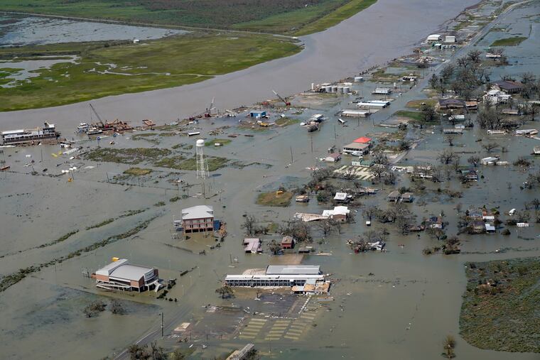
Regaining its status as a major hurricane, Delta was targeting the southwestern Louisiana coast where it was forecast to make landfall Friday afternoon hauntingly close to where Hurricane Laura struck in August.
Delta’s peak winds were up to 120 mph late Thursday night, but the National Hurricane Center said they probably would back off some before the hurricane reached land.
On Aug. 27 Laura made landfall with top winds of 150 mph, devastating parts of the Louisiana coast and the Lake Charles area, where it knocked out the National Weather Service radar unit, leaving the region with a “radar hole.”
The weather service on Wednesday delivered an emergency backup unit to the area supplied by the University of Oklahoma, said Jessica Schultz, deputy director of NOAA’s Radar Operations Center.
Delta would be the 10th tropical storm of the season to make U.S. landfall, setting a record that has stood for more than a century. Of those 10, Delta would be the seventh to have hit the Gulf Coast, including Hurricane Sally last month.
» READ MORE: Hurricane Laura victims may go weeks without power; death total climbs to 14
“It’s just crazy; one after the other,” said Dave Samuel, a meteorologist with AccuWeather Inc. He added that the traffic is due to waters in the Gulf of Mexico that are “through the roof” warm.
“This season has been relentless,” said Louisiana Gov. John Bel Edwards, adding that President Donald Trump already has agreed to sign an emergency declaration.
The hurricane center warned of “life-threatening storm surge” along the coast and issued “hurricane warnings” for areas from eastern Texas to Morgan City, La., about 85 miles from New Orleans.
After landfall, Delta’s remnants were forecast to track northeast and toward the Philadelphia region.
Interacting with a frontal system, what’s left of Delta likely will contribute to widespread soaking rains, the National Weather Service in Mount Holly said, perhaps one to three inches over a three-day period Sunday into Tuesday.
» READ MORE: Isaias leaves destruction and thousands in Philly region without power: ‘The worst ... is yet to come’
However, no flooding is expected, given the recent run of dry weather, and the rains might help the trees retain their leaves and prolong the impending foliage show.
In short, the impacts around here won’t approach whatever happens along the Louisiana coast, which is still recovering from Laura.
On top of everything else, Laura left the region with a so-called radar hole by knocking out the NEXRAD system at Lake Charles.
“The high winds and heavy rains took away the top part of the antenna,” Schultz said. “It probably won’t be fully operational until late March.” The nearest unit, about 85 miles away in Fort Polk, would be “normally adequate” for radar coverage, but “normally” is not an adverb associated with hurricanes.
She said the portable unit would be important for detecting those “fast-moving low-level features,” like tornadoes.