A hyperactive hurricane season has spared Philly and the Atlantic Coast, but the luck may not last
With yet another active season, researchers say this may be the future of hurricanes. Worldwide warming, and even cleaner air, are factors, they say.
As it drove by the East Coast while staying well out to sea, the once-potent Hurricane Lee limited its impact to days of rip currents and high seas, another installment in a quite remarkable 2023 Atlantic tropical storm season.
Although this has been one of the more active — and puzzling — seasons in the period of record, the U.S. Atlantic Coast has been spared a direct hit.
What’s more, neither the Philadelphia region nor most of the eastern United States has been pestered by inland flooding from any of the 13 named storms, including the five hurricanes, that have formed in the Atlantic Basin, which includes the Gulf of Mexico and the Caribbean Sea.
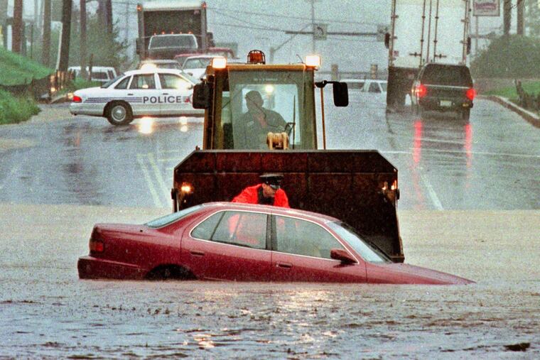
Recall that in the 2020 and 2021 seasons, the Philly area endured significant impact from six tropical remnants, culminating in the destructive rains of Ida.
» READ MORE: The 2020 and 2021 seasons may have set records for tropical-storm remnants affecting Philly
Meteorologists caution that the 2023 season has a ways to go, and record-warm sea-surface temperatures persist in the tropical storm spawning regions. “We’re only halfway home,” said Matt Rosencrans, the lead hurricane forecaster at NOAA’s Climate Prediction Center. That’s almost literally true: On average, half of all named storms during the June 1-Nov. 30 season have occurred from Sept. 16 onward.
But outside of extreme northern Florida and nearby areas affected by Idalia in August, so far, so lucky.
Pacific enigma
Despite the warm waters in the Atlantic — fuel for hurricanes — in their preseason outlook U.S. hurricane forecasters held their fire on calling for an above-normal season. On average, 14 named storms form in the basin, those with winds of 39 mph; seven hurricanes, with top winds of 74 mph or more; and three “major” hurricanes, with winds of at least 111 mph.
The reason for their reluctance: The waters over vast expanses of the tropical Pacific also were becoming anomalously warm, the sign of a burgeoning El Niño event. On Monday, those waters were approaching 3 degrees Fahrenheit above normal, according to the climate center. Typically, interacting with the overlying atmosphere, El Niño generates potent west-to-east upper-air winds that can shear off Atlantic storms before they can mature into hurricanes.
» READ MORE: In the pre-season outlooks, forecasters hedged on hurricane numbers, with good reason.
“I don’t really see El Niño having much of an impact on vertical wind shear as of yet,” said Philip Klotzbach, hurricane specialist at Colorado State University. In fact, Klotzbach and Rosencrans said this week that the shear remains below average.
So far at least, the Atlantic warmth appears to be dominating.
Atlantic steam bath
Atlantic sea-surface temperatures in the hurricane-spawning grounds are running as much as 5.5 degrees Fahrenheit above long-term averages. “That is just ridiculous for a tropical ocean,” said Klotzbach.
Behind the surge is the planet’s rising temperature and — perhaps surprisingly — so is cleaner air, hurricane specialists say. Disentangling the contributions of each is a subject of ongoing research, said Rosencrans.
Tougher pollution standards in Europe and North American have scrubbed out sun-screening aerosols, he said, allowing more of the sun’s energy to heat the Atlantic waters.
Clean air fallout?
While the United States experienced a few deadly and destructive hurricanes between 1970 and 1995, including Andrew in 1992, the Atlantic Basin was in a tropical storm lull period with well-below-normal activity.
Amy Clement, a professor and researcher at the University of Miami’s School of Marine, Atmospheric, and Earth Science, is among those who hold that tougher clean-air standards were significant contributors. They peeled away veils of pollutants that had blunted some of the sun’s energy.
Industrial pollution “was kind of a big foot squashing the activity by putting a shadow over the tropical Atlantic, making it cooler,” said Bryan Norcross, the Fox Weather hurricane specialist.
‘Accident of history’
The research into the effects of the cleaner air has called into question a long-standing hypothesis that lull and active hurricane periods alternated in 25- to 40-year cycles, tied to changes in the Atlantic circulation.
Norcross said that he isn’t ready to dismiss the hypothesis of cycles driven by the ocean, but “it might be a more minor effect than we thought.”
One issue in verifying the theory would be the length of the record. NOAA dates the usable hurricane-observation period to 1851, and that would accommodate only two or three complete lull-active cycles that each would take 50 to 80 years to play out.
Other factors might have been in play in hurricane variability, said Norcross, such as volcanic dust.
What to expect
Anything.
Hurricane and tropical storm numbers have varied from year to year, and their impact even more so. Once formed, hurricanes behave more or less like lottery balls bobbing in the water, making it all but impossible to predict landfalls in a given season.
For example, a total of five hurricanes made landfall in Florida in 2004 and 2005, and then not another one for 12 years, despite a sequence of very active seasons.
For all the increased storm traffic, the numbers of U.S. land-falling hurricanes have decreased, according to the National Hurricane Center, with only three in 2021 and 2022, and one so far this year. On average, 19 made U.S. landfall per decade from 1851 to 1950, compared with 14 since 1950.
Similarly, it is not possible to know which storms or their remnants will become dangerous wind and rainmakers inland. The Philadelphia region has experienced horrific damage from tropical storm remnants, with Floyd’s, in 1999, and Ida’s, in 2021, among the deadliest.
» READ MORE: A timeline of Ida's destruction in the Philly region
However, despite the brisk overall numbers the last two years, no storms have come close to having an impact around Philly.
That luck may be on thin ice. Clement said she expects the Atlantic to keep warming, perhaps nudging the hurricane development zone northward.
Climate change is expected to add about 7% more to hurricane rainfall totals by the end of the century, said Rosencrans, and rising seas are adding more power to storm-surge waves.
The explosive development in the ‘70s, ‘80s, and early ‘90s occurred when the Atlantic and Gulf Coasts experienced “fewer shocks from hurricanes,” said Clement, thanks in part to dirtier air.
Now, with so much more in the way on the built-up coasts, that protective veil “is not coming back.”
