Severe storm, flood watches in effect as heavy rains start to rock the region
The National Weather Service has issued flood and severe thunderstorm watches for the Philadelphia region Sunday, cautioning that multiple rounds of heavy downpours are expected.
Rounds of severe thunderstorms struck much of the Philadelphia region and beyond starting Sunday afternoon, with areas west of the city getting hit especially hard by slow-moving cells fueled by days of warm, humid conditions.
Flooding was possible through midnight as water continued to rise in creeks, rivers, and streams in parts of Delaware, Philadelphia, Montgomery, and Bucks Counties in Pennsylvania, and Salem, Gloucester, Camden, and Burlington Counties in New Jersey.
Heavy downpours are possible through the evening as the atmosphere was primed for precipitation.
Indeed, a flash flood warning was issued through 9:30 p.m. for parts of Southeastern Pennsylvania, including Philadelphia. By 6 p.m., radar was indicating thunderstorms producing heavy rain across the area, with an additional 1 to 3 inches possible. But the National Weather Service had also flood watch until midnight and a severe thunderstorm watch until 8 p.m.
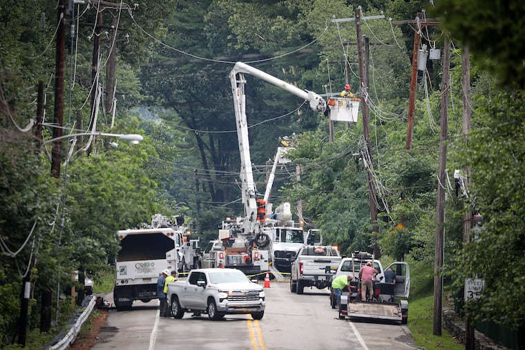
Storms had already begun racing across parts of the region by early afternoon. Submerged vehicles were reported in the Montgomery County communities of Upper Merion and Conshohocken and wires were down.
The ground in many communities was already saturated before the rains came, leading to flash-flood conditions.
Heavy cells struck early well west of Philadelphia. There were reports of multiple water rescues in both cars and homes in the Reading area in Berks County. U.S. Route 222 at exit 61 had to be closed due to flooding as of late afternoon.
Most of the storm was expected to be offshore by 10 p.m.
Matt Brudy, a meteorologist at the weather service’s Mount Holly office, said the strong storms are the result of a system that stretches from North Carolina through New England — but what looks like the heaviest rain could target the Philadelphia area.
Days of high humidity and high temperatures have left the atmosphere in the region like a soaked towel just waiting to be wrung out.
“We have a stationary boundary across parts of eastern PA,” Brudy said. “We’re getting a big push of moisture. And the slow movement is leading to training storms and winds over the same area for prolonged periods of time.”
That comes as some areas have already gotten walloped in recent days, he added.
“It is really going to really exacerbate the flash flooding,” he said.
As of Sunday afternoon, the system appears strongest just west of the I-95 corridor, but Brudy said there could be severe storms stretching down into Delaware and Maryland, and into South Jersey.
“We do expect slowly that it’s going to creep over into the corridor later on,” he said.
It’s likely some summer events will be affected. For example, a concert for members of Longwood Gardens in Kennett Square, featuring Steve Riley and the Mamou Playboys, has been canceled. The gardens, however, will remain open until 10 p.m. and feature the Illuminated Fountain Performance “Country Roads” at 9 p.m.
The forecast calls for continued showers and thunderstorms in the afternoon, with some severe, packing damaging winds and soaking rains with a high near 83. In some areas, rain amounts will total from half an inch to an inch, but other areas could see much more.
There could be a break after midnight, with winds and rain calming. But the atmosphere looks to remain unsettled with a chance of showers and thunderstorms after 11 a.m. Monday, with more possible until late evening.
The best chance of a break comes Tuesday, with sunny skies and a high near 89.
