Best bike trails near Philadelphia worth exploring
Bike trails are are perfect for the pandemic, whether you want to destress, work out, keep your kids occupied, or just get out of the house. Here are some good ones to check out.
The Greater Philadelphia region is home to hundreds of miles of trails. Some greet you with riverside views. Others are scattered with historic attractions. Cruise through any of them, and you’ll find ample sunshine, fresh air, and picnic stop-offs to enjoy.
Help make this guide better
Here are a few options to check out, both within city limits and beyond. For more places to explore, visit The Circuit Trails (circuittrails.org), a network of trails that stretches through Philadelphia, Bucks, Chester, Delaware, and Montgomery Counties and southwest New Jersey.
Schuylkill River Trail and Martin Luther King Jr. Drive Loop
Length: About 8 miles
Location: Starts at the Philadelphia Museum of Art (2600 Benjamin Franklin Pkwy.) and follows the Schuylkill to the Falls Bridge in East Falls; after crossing over the bridge to the opposite side of the river, you’ll bike back toward the city on Martin Luther King Jr. Drive until you return to the Philadelphia Museum of Art
Best for: All bikes
Terrain: Flat, asphalt
Kid-friendly: Yes
A popular spot for cyclists and runners, this urban trail takes you along the Schuylkill, with waterfront views throughout the entire ride. The trail is flat, and takes about an hour for the average cyclist. The first half runs along Kelly Drive, so expect cars whizzing by on your right. The second half follows Martin Luther King Jr. Drive, which is currently closed to traffic to make social distancing easier. Hop off the trail and cruise directly on the road. Afterward, there are plenty of grassy picnic spots behind the Philadelphia Museum of Art, where you’ll start and finish your ride.
Wissahickon Valley Park Trail / Forbidden Drive
Length: About 5.5 miles
Location: From Lincoln Drive and Forbidden Drive to Germantown Pike and Rodgers Drive
Best for: Hybrids and mountain bikes, but doable on a road bike, especially those with thicker tires
Terrain: Flat, with optional hillier offshoots for mountain bikers; asphalt, dirt, and gravel
Kid-friendly: Yes
A wooded refuge just miles from the city’s center, this flat and wide, mostly gravel trail winds you along Wissahickon Creek. While you might see the occasional horseback rider, you won’t see any cars beyond the parking lots. There are plenty of offshoots into the woods, too, if you wish to steer off the main path and climb steeper and rockier terrain.
Schuylkill River Trail to Valley Forge
Length: About 24 miles, one-way
Location: From the Philadelphia Museum of Art to Valley Forge National Historical Park, 1400 North Outer Line Dr., King of Prussia
Best for: All bikes
Terrain: Flat, mostly asphalt with a small stretch of gravel and wooded boardwalk area near Manayunk
Kid-friendly: No; small stretch of road riding required
This route clocks in at just under 50 miles round-trip, and takes about four to five hours, depending on your pace. You’ll start at the Philadelphia Museum of Art. Instead of turning at Falls Bridge as you would for the Martin Luther King Jr. Drive Loop (see above), continue straight for a half-mile until you hit Ridge Avenue. At this point, you’ll take a left on the road for a short stretch, following Ridge Avenue until it connects to Main Street. Ride Main Street through Manayunk for about a half-mile to Lock Street, at which point you can pick back up on the Schuylkill River Trail, and cruise the final 18 miles to Valley Forge on a peaceful, tree-lined path.
Length: 58.89 miles
Location: South Delaware Drive/SR 611 in Easton to Jefferson Ave. in Bristol
Best for: Hybrids and mountain bikes, or road bikes with thicker tires
Terrain: Flat, crushed stone trail
Kid-friendly: Yes; trail is intersected by roadways in several locations
Part of the 165-mile long D&L Trail, the Delaware Canal Towpath stretches from Easton to Bristol, offering a ride full of nature, history, and towns to explore. Back in the mid-1800s, the main canal was used to transport coal to industrial cities in north Jersey and New York City. As you follow the canal, you’ll take in views of the Delaware River, along with those of 19th-century mills, lockkeeper houses, and stone-arched culverts. The trail winds through several quaint towns, too, including New Hope and Lambertville. If you aren’t up for an all-day adventure, check out one of the shorter loops stemming from the trail, found here.
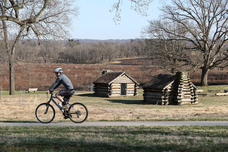
Valley Forge National Historical Park
Length: 18.2 miles of trails
Location: 1400 N. Outer Line Dr., King of Prussia
Best for: All bikes
Terrain: Flat and hillier options, about half of the trails are paved
Kid-friendly: Yes
Valley Forge was the site of the 1777-78 winter encampment of the Continental Army. Across its 3,500 acres of rolling hills, you’ll find more than 18 miles of authorized biking trails and numerous Revolutionary War monuments to check out. Multiple trails wind throughout the park; a map can be found here. On the south side, a paved, 5-mile loop (the Joseph Plumb Martin loop) connects many of the park’s historic and interpretive sites. On the north side, 2 miles of the paved Schuylkill River Trail run through the park. There are about 12 miles of flat, unpaved trails to explore, too.
Length: 9.5 miles
Location: Multiple access points, including 800 Welsh Rd., 1750 Byberry Rd., and through Rockledge Park at Robbins & Rockledge Avenues
Best for: Hybrids and mountain bikes
Terrain: Short hills interspersed with flat stretches, pavement and crushed gravel
Kid-friendly: Yes, but trail is intersected by a train crossing and roadways in several locations, and includes hills
Built on the former Fox Chase-Newtown SEPTA rail line, this gravel trail takes you through Pennypack Creek valley, where meadows, trees, and wildlife abound. You’ll cross a 165-foot-steel bridge, where you can peer over a small stream valley from 35 feet above. And bring a pair of binoculars for when you reach Bethayres Swamp, a designated Audubon IBA (important bird area).
Length: 36 miles of trails
Location: 1268 Palisades Dr., Leesport, Pa.
Best for: Mountain bikes
Terrain: Includes gravel roads, partially paved roads, grassy fields, hills and flat stretches
Kid-friendly: Best for older kids experienced with mountain biking and climbing hills
This Berks County lake is surrounded by 6,200 acres of land, featuring more than 35 miles of trails to explore. The main trail is about 30 miles, and winds along the lake, hugging the shore at times and turning into the woods at others. It offers a mix of terrain, from hills to muddy sections to open fields, and is considered best for intermediate mountain bikers.
Length: 50 miles of trails
Location: 1 Henkinsifkin Rd., Woodbine, N.J.
Best for: Mountain bikes
Terrain: Diverse, mostly flat terrain, with both single tracks and wider stretches
Kid-friendly: Yes; some trails better for older kids
Book a campsite, and load up your mountain bikes for a little getaway at this state forest, just a 20-minute drive from the Jersey Shore. Surrounding trails include plenty of mixed terrain, including flat loops, single tracks, and technical spots with roots.
