More than a month’s worth of rain fell in some parts of the Philly area as the region gets a deluge
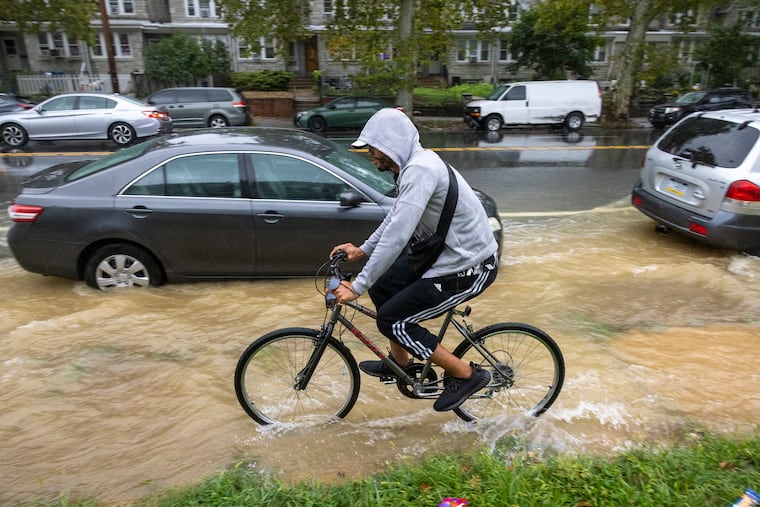
Frankford Creek crested past flood stage, and the Wissahickon had reached flood level. Over 4.5 inches fell in some areas.
It wasn’t Ida Redux, but parts of the parched Philadelphia region were deluged Tuesday with more than a month’s worth of rain, putting a dent at least in the growing precipitation deficits.
More than 4.5 inches of rain were measured in areas of Delaware, Montgomery, and Cape May Counties, with 2 and 3-plus-inch amounts common elsewhere.
At the bone-dry Jersey Shore, more than 2 inches fell between 10 a.m. and 1 p.m. at the Atlantic City Airport, and at one point a tornado warning was in effect for Sea Isle City, although no sighting was reported. The 1.23 inches measured at Philadelphia International Airport was the most since Aug. 11, with more than 2 inches in other parts of the city.
However, with stream levels depressed by the recent dryness, no major flooding occurred. “You almost needed these totals in one hour for anything to really happen,” said Trent Davis, a meteorologist at the National Weather Service Office in Mount Holly.
At midmorning, Frankford Creek did reach moderate flood stage, and the Wissahickon Creek at Manayunk hit flood stage, but in the early afternoon the weather service decided to drop the flood watch as rain intensities backed off.
Showers remained possible through Wednesday night, but the forecast amounts weren’t impressive.
In the end, the rains were more notable for their recent absence. Expect the regional drought watches to survive the onslaught.
The rain amounts, said Peter Furey, executive director of the New Jersey Farm Bureau, were “not as much as we were hoping.” His farmers are hurting badly from the dryness and heat of July and August, he said, compounded by the recoveries from COVID-19 losses and a weak economy.
» READ MORE: A drought watch is up for all of New Jersey
Last year it seemed that the words flash flood watch appeared as commonly as road work ahead. A healthy August surplus was topped off with rains from the remnants of Ida. But flood advisories have been scarce lately as rain deficits have deepened rapidly in the last 30 days, a period memorable for a brown rain of dried-up leaves.
Heading into Tuesday, Philly’s rainfall had been less than half of normal for the preceding 30 days, as it had been in the prime farm areas of South Jersey, according to the Middle Atlantic River Forecast Center. In Cape May County, rainfall had been just over 20% of normal.
The entire Philadelphia region is under drought watches, with residents asked to conserve water, and we’re not used to this. For Philadelphia and the neighboring surrounding counties, this is the first drought watch in more than five years, according to the Pennsylvania Department of Environmental Protection.
The dryness has made the soil so hard, “you can hardly plow it,” said Furey.
“Everybody has been damaged,” he said. ”The question is how much.”
» READ MORE: Pennsylvania declares drought watch for Philly and surrounding counties, asks residents to conserve water
The summer dryness and heat likely will hurt the likes of corn and soybean yields, said Furey and Andrew Frankenfeld, educator at Penn State’s Montgomery County Agricultural Extension.
“The homeowners can see their brown lawns,” said Furey, “and just imagine what it’s like on a farm.”
But Tuesday’s rain should yield some benefits, at least on the home fronts, said Frankenfeld.
“Lawns and landscape plants should recover in a couple weeks with this moisture,” he said. “Also hopefully cooler weather and continued rain will change our brown landscape to green.”
And maybe the rains will have been a harbinger of a change of fortune.
No doubt it was coincidental, but the last two drought watches appeared to have a cloud-seeding effect. After one was declared on Feb. 14, 2017, rainfall was above normal in Philadelphia the next month, and the watch was lifted on April 6.
What happened after the declaration of Aug. 5, 2011, was almost unbelievable. That month, juiced by the remnants of Irene, the city had its rainiest month on record with 19.11 inches.
For now no tropical storms are threatening the United States. Earl was taking aim at Bermuda, and Danielle was out there plunging waves.
However, another system could squeeze out more rain over the Philly region early next week, said Dave Dombek, senior meteorologist at AccuWeather Inc. At the very least, he said, it appears that the ultra-dry pattern shows signs of abating.
“Finally, you’re getting some beneficial rain,” he said. “We at least will have opportunities.”
But no more Irenes, please.
