A thunderstorm ‘microburst’ likely added to Montgomery County’s storm damage on Wednesday
Did the smoke steal some of the storm's thunder? The National Weather Service has ruled out a tornado.
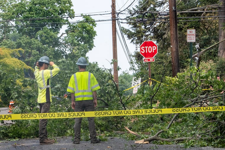
A cluster of towns in south-central Montgomery County that got pelted by quarter-size ice rocks and wind gusts past 50 mph on Wednesday likely was the target of a thunderstorm “microburst,” meteorologists said Thursday.
The National Weather Service is not sending the tornado detectives to the area, which includes the likes of Glenside, Flourtown, Blue Bell, and Abington Township, since the damage was caused primarily by “straight-line winds,” said Michael Silva, a lead meteorologist at the Mount Holly office.
“We really took a hit,” said Dr. John Richardson, a dentist who lives in Blue Bell and had to push back morning appointments at his Bryn Mawr office because of closed roads. “Worst storm damage I’ve had in the 24 years living here.”
At least some of the damage probably was caused by a microburst — a narrow and powerful thunderstorm downdraft no more than 2.5 miles in diameter — said Tom Kines, senior meteorologist with AccuWeather Inc. Microbursts are especially dangerous to aircraft.
“A microburst can cause as much damage as a tornado,” Kines said.
Silva said a microburst likely developed “toward the end” of the severe thunderstorm, which stuck between 3 and 3:30 p.m. and constituted one of several that affected the region almost randomly as a potent front interacted with the sultry air mass.
The storms were damaging enough, microbursts notwithstanding. More than 125,000 Peco customers lost power, and of the 8,000 still without power Thursday afternoon, 7,800 were in Montgomery County. SEPTA experienced storm-related delays on every Regional Rail line. Winds took down trees and blocked roads.
» READ MORE: Storms knock out power to thousands in Philly region and disrupt SEPTA rail lines — but they do rout the smoke
The weather service posted several reports of large hail in South Jersey, however the winds were not as impressive as they were in Montco, said Silva.
It is at least possible that all that smoke over Philadelphia from the western wildfires stole some of the storms’ thunder, Kines said. By dimming the sunlight, it likely lessened the ground heating so essential for the updrafts that generate storms.
While the front that set off the storms laundered most of the smoke from the skies, a highly diluted form of milky haze was evident again Thursday, and an air quality alert was posted for Camden County.
» READ MORE: Western wildfire smoke is causing some of Philly’s worst air pollution in years. Can COVID masks help?
“A lot of the smoke did wash out,” said Silva, “but there’s a little more out there than we hoped.”
It is entirely possible that it will make a more-vigorous reappearance on Monday as upper-air winds become more favorable for smoke commuting.
More showers also are possible Monday.
In the meantime, the weekend looks decent with sun most of the time and temperatures in the 80s, although humidity is expected to drive up the heat index by Sunday.
