Snow shocked Philadelphia in December 1960. The forecast whiffs these days tend to be quite different.
The snow came with no warning and shut down the city for days.
A snowflake wouldn’t have a snowball’s chance in Philadelphia.
In the city that was a cradle of urban snow-fighting, the snow-emergency chief declared all-out war on wintry interruption, boldly proclaiming, “Philadelphia will be in better shape to cope with snowfall … this year than ever before.”
The streets commissioner assured that his “snow-fighting forces were prepared.” The city was ready for anything — anything but what happened two days later.
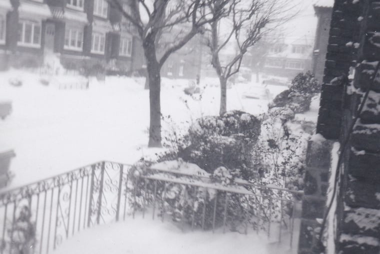
On Dec. 11-12, 1960, 14.6 official inches of utterly shocking snow fell upon Philadelphia, then the nation’s fourth-largest city, and rocked the East Coast with blizzard-like conditions.
The storm was blamed for at least 11 deaths in the region and 111 total, for costing Philadelphia $20 million for snow fighting, and for business losses of $30 million in today’s dollars during the peak of the holiday-shopping season, according to the Daily News. Schools were shut down for three days, back when everyone had to report to an actual building.
» READ MORE: How much snow for Philly this winter? After a bust year, TV meteorologists take their shots
At a time when more than 2 million people lived in Philadelphia, no one was telecommuting, and the city was ingesting vast hosts of suburban workers daily, the snow shut down the entire transportation system.
It remains a record for an early season snowfall, and was one of the most disruptive weather events in the region’s history, in large part because no one saw it coming, nor believed it even as it was happening.
Snow-fighting crews were caught with their leggings down. The streets commissioner delayed sending out his forces, hoping to save some money in overtime.
He evidently made the tragic error of trusting the forecasts.
This wasn’t the city’s first experience with snow coming out of the blue. In those days, using computer models to forecast weather was a work in progress.
Since then, modeling has made tremendous advances, and only rarely has the region been ambushed by a snowstorm.
If anything, today the problem is quite the opposite, and with a major storm threat brewing out there, we might well be about to witness another case study.
About that storm
The forecast on the front page of the Philadelphia Sunday Inquirer on Dec. 11 was for partly cloudy skies with a high of 35. The U.S. Weather Bureau’s morning update called for snow changing to rain.
But by afternoon, the rain had vanished from a snowy forecast that called for “4 inches or more.” By midnight, weather records show, just under 4 inches had accumulated. Then came the “or more,” an unforeseen snow blitz ignited by a nor’easter suddenly exploding off the coast.
Streets Commissioner David M. Smallwood later said he didn’t realize until he was walking his dog at midnight than the storm would be worse than expected. He then decided to send in the plows at 8 a.m. Monday. By then, Philadelphia was entombed in white.
It is unclear whether anyone in city government was familiar with the recommendations of the nation’s first snow-fighting convention, convened in City Hall by Philadelphia public works chief Morris Cooke in 1914. Key among them: The delegates advised that removal work “should commence as soon as the snow has covered the pavements and the indications point to the storm continuing, and should be carried on continuously.”
That didn’t happen on Dec. 11, 1960.
It appeared that the city would get redemption just 10 days later as another significant snowstorm was forecast. But that one turned out be a dud, a phenomenon that would be repeated.
Surprising developments
Snow ambushes these days are rare. The region hasn’t weathered a shutdown snowfall that would qualify as a total surprise since January 2000.
» READ MORE: The case of the disappearing snow: A stormy week — for the computers
The problem these days is more likely to be over-forecasting, as was the case in a January 2015 “storm.” Philadelphia was expecting 1 to 2 feet. In New York, where up to 30 inches was forecast, Mayor Bill De Blasio warned, “This will most likely be one of the largest blizzards in the history of New York City.” He preemptively ordered all traffic removed from the streets before a flake was sighted.
What resulted was the “Flizzard of 2015.” Philly got 1 to 2 inches; New York, 5.
» READ MORE: 'Flakegate' and the incredible shrinking snow totals
Forecasters blamed the computer models, and they had a case.
They consult scores of models run by the United States, the European Union, Canada, and elsewhere, and sometimes the machine agree about as much as Donald Trump and Joe Biden supporters.
Chances are on any given winter day, a model is seeing a snowstorm out there somewhere. It’s “chaos,” says Chet Henricksen, former chief local meteorologist at the National Weather Service.
» READ MORE: Much has changed in 2020. The magic and mystery of snow persist. | Book excerpt
Once again, models are differing over the outcome of a storm due to affect the region Wednesday with heavy snow possible.
The fundamental problems remain: The atmosphere is a capricious, three-dimensional gas. Weather observations vital to computers are incomplete, given that most of the planet is uninhabited and is about 70% water.
Expect multiple changes in the forecast between now and Wednesday. At least it isn’t 1960 anymore.
