Tropical storms will keep popping, but how will we know which is the next Big One?
Salt evidently is a secret ingredient in predicting when a hurricane might intensify suddenly, as forecasters look to the oceans for clues.
That the record-setting tropical storm traffic in the Atlantic Basin is going to persist is all but a given, forecasters say. The deeper and more frightening question is, Will any of the storms become monstrously destructive hurricanes and when will we know it?
As they relearned in August with Laura, whose winds doubled from 75 to 150 mph in 36 hours, the answers might not come until the hurricane is on the very doorstep of a heavily populated coast. Track forecasts have improved significantly, but the National Oceanic and Atmospheric Administration acknowledges that predictions of intensity changes haven’t kept pace.
The riddles remain as elusive as the inner lives of the oceans, related to things as prosaic as salt and ocean spray, and as cosmic as the behavior of the Amazon, Orinoco, and the Mississippi.
While researchers have known that those three mighty rivers are rich sources of freshwater that layer hurricane-spawning grounds with the equivalent of lighter fluid, only in recent years have they escalated their efforts to find out what’s going on below the surface.
They include dispatching an armada of robot submarines, an initiative spurred in part by Hurricane Sandy, which devastated parts of the Jersey coast and caused tremendous damage across the Philadelphia region.
“We realized the last few years we have to deal with the problem, we can’t just deal with the atmosphere,” said Frank Marks, director of the Hurricane Research Division at NOAA’s Atlantic Oceanographic and Meteorological Lab (AOML). "The ocean observations are quite a number of years behind what they are in the atmosphere.”
» READ MORE: Hurricane season is marking the anniversary of the deadliest U.S. disaster with more records
“You need to know more than the surface," said Gustavo Jorge Goni, director of AOML’s Physical Oceanography Division, which is deeply involved in the escalating efforts to probe the secrets of the Atlantic, the Caribbean Sea, and the Gulf of Mexico. "You need to know what’s under surface.”
Based on the forecasts, more case-study opportunities are coming.
Already 23 named storms, those with winds of 39 mph or better, have formed in the basin. Conditions remain favorable for more and the record of 28, set in 2005, is in serious trouble.
Oceanic minefield
Researchers don’t know all the factors that cause a tropical storm to mutate into an explosive hurricane.
They do know that warm waters are the sine qua non fueling hurricanes. The Atlantic Basin is a minefield of warm-water hot spots, including the Gulf Stream and the Gulf of Mexico’s loop currents, which helped ignite the cosmically destructive Hurricane Katrina in 2005.
» READ MORE: Gulf Coast residents mark 15th anniversary of Katrina
One source of the oceanic heat is freshwater from three of the world’s largest rivers. They can flood the basin with layers of freshwater that warm quickly under the tropical sun. They are buoyed by the denser, saltier waters below that inhibit sinking.
Similarly, it is important to know where the warm water isn’t, and to be on top of sudden losses of storm intensity. At stake is credibility, Goni said, and how the public might respond to warnings in the future.
“You want the public to trust you,” he said. “You can’t tell them you’ll get a Category 4," with peak winds up to 156 mph, "and they get a 2,” which would have top winds at 110.
» READ MORE: Hurricane Laura gains strength, could bring ‘unsurvivable’ storm surge
The key is to measure the depth of that freshwater, the temperature, and the salt content of the underlying water. Those efforts are getting an impetus from an unrelated source — concerns over climate change.
One of the overarching anxieties is the future of the Atlantic “conveyor belt” currents that carry warm water toward the Arctic, and transport subsurface cold water southward. Any radical change to the Atlantic’s circulation could have profound effects on climate.
Researchers say the enhanced monitoring is serving both climate and hurricane interests.
Diving for data
These days the government has a patchwork navy on the case.
Satellites are of some use, said Goni. They can measure the heights of sea levels, a proxy measure for temperatures.
“Ships of opportunity” — for example, freighters from New York Harbor to Johannesburg — drop instrument probes along the way and/or monitor the temperature and salinity of water that they use to cool their engines. Drifts and floats relay near-surface data.
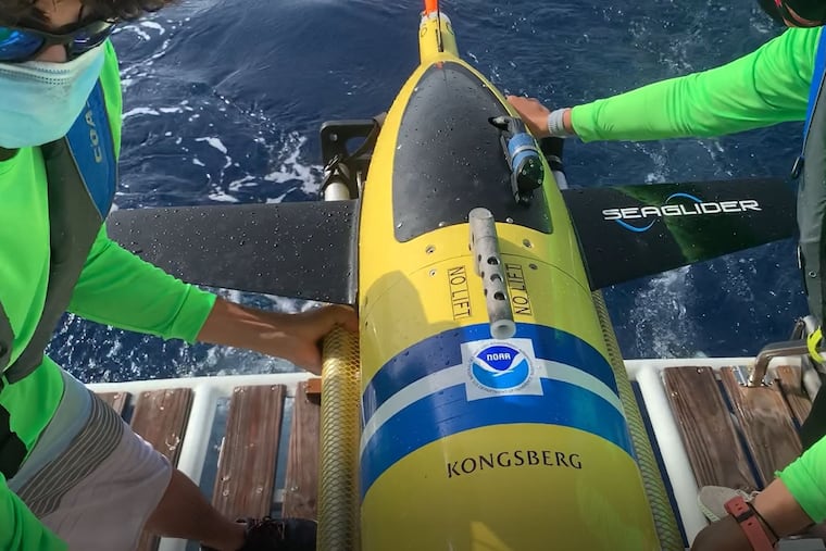
But subsurface observing has made quantum gains in the last six years thanks to an armada of robotic submarine gliders.
No more than about 120 pounds and about 6 feet long, they can easily be launched from small craft at strategic locations.
They can measure freshwater depth, temperatures, and salinity down to about 3,000 feet, said Goni, adding that 30 of them provided from different sources, including Rutgers University, are mining the hurricane spawning grounds.
Another 30 elsewhere are providing useful data, said Scott Glenn, an oceanographer and professor at Rutgers University, who has been involved with the project since it got underway in 2014.
An individual glider mission can last a month, three months, or a year, and cover hundreds of miles of ocean, said Glenn. They can travel about 12 miles a day, bobbing up and down in the water. Eventually they resurface and are recovered and reused.
The gliders transmit continuous real-time data that in turn are ingested into the computer models that try to figure out what a hurricane is going to do.
And the beauty is that they can be controlled from anywhere, provided the operator has a computer and internet access.
“You could do it from a Rutgers football game,” Glenn said.
“We’ve done that.” He said he couldn’t remember which game, “but I think Rutgers lost.”