How the most destructive nor’easter in Shore history primed beach towns for a building boom
The Ash Wednesday Storm of 1962 sliced Long Beach Island into five pieces and devastated the barrier islands. What followed was a massive increase in real estate values.
Martin Ross’ first hint that the Jersey Shore was about to be devastated by the most-powerful winter storm in its history came in a phone call from the woman who would become his wife.
“The water was up to the steps,” he recalled her saying. She was living in Margate, and Ross was a young meteorologist working the overnight shift at the U.S. Weather Bureau office about 10 miles landward of the shores being inundated by storm waves.
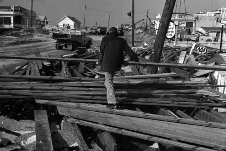
Beginning on March 5, the Jersey Shore and the Atlantic coast from the Outer Banks to New York endured three days of hell from the “Ash Wednesday Storm” of 1962 that would kill 22 people in New Jersey and Delaware, damage or destroy 50,000 houses, knock structures off their foundations, haunt survivors for the rest of their lives — and prime the beach towns for a remarkable building boom.
» READ MORE: For Jersey Shore homeowners, hurricane and flood threats are worth the risk
“Nobody had a clue what was happening at that time,” Ross said. He still hasn’t forgotten the sound of those winds that fomented the riotous surf through five astronomically high, full-moon tides.
The waves, some incited by gales that traveled 1,200 miles across the North Atlantic, crashed through Harvey Cedars, creating a renegade 80-foot-wide channel, three to seven feet deep, from the ocean and Barnegat Bay.
So overwhelmed were the storm drains in Long Beach Township that a then-12-year-old Joe Mancini watched in wonder as the waters gushed upward. “It was like a reverse Niagara Falls,” said Mancini, now the town’s mayor.
“We had the ocean rolling down the street in front of our house, and the bay in our back yard.”
It was all so scary that the U.S. secretary of the interior suggested making the barrier islands natural buffer zones to protect the mainland.
But in the decades since, those barrier islands have been redefined in ways that no one could have envisioned while initially surveying the wreckage.
» READ MORE: South Jersey has fastest sea level rise on East Coast, study finds
The unprecedented, post-storm development boom has turned the sandy soil to gold and continues today. Real estate values proved to be stronger than the storm. The average home price in Harvey Cedars was $1.4 million in the state’s 2021 sales report.
In raw dollars, $1.5 billion worth of property inhabited the barrier islands from Cape May Point to Barnegat Light in 1962; adjusted for inflation that would be $8.7 billion. That’s compared with $79.1 billion today — a more than 800% increase — according to an Inquirer analysis of state tax data.
“I sort of missed the boat,” Ross says un-resentfully. “After the storm there was a lot of property for sale nobody wanted to buy. So for about $10,000 you could have bought a lot near a beach block. It would have been the best investment I ever made.”
He didn’t. Others did buy property in the aftermath, and it paid off prodigiously. What followed was a land rush at the beaches. On the mainland, the buildings are worth about double the land values. At the Shore, the land is well more than twice as valuable. In Stone Harbor — average home price $1.8 million — land is more than triple the value of the buildings, according to assessment records.
Those who experienced the Ash Wednesday Storm — or bought land in its aftermath — would prefer not to think what a storm of similar magnitude might do to the Shore and its phalanx of vacation homes and investment properties in an era when a warming climate is raising water levels and stirring more potent waves.
The storm
So much of natural destruction is sudden — lightning, tornadoes, hailstorms, and the like. Sandy, effectively a hurricane, wrought incredible damage, particularly on Long Beach Island, when it made landfall in 2012.
» READ MORE: For some at the Jersey Shore, rebound from Sandy has been easier
The storms and their impact were so different that it would be difficult to compare Sandy with the ‘62 cataclysmic nor’easter, named for the onshore winds from the northeast generated by coastal cyclones.
“Sandy was really bad,” said Mancini, “but this sucker lasted three days.”
It began harmlessly: On March 4 an area of low pressure, or lighter air, that had been centered near Iowa moved southeast and merged with what had been “a little low” in the vicinity of the Bahamas, said Jim Eberwine, a former National Weather Service meteorologist. As it moved north, the merged system mutated into a dangerous cyclone off the Carolina coast.
An area of blocking high pressure, or heavier air, prevented the storm from scooting off the coast. The pressure differences — think of air escaping from a punctured tire — created gusts to near 60 mph.
At the time, Eberwine was a teenager living in Brewerytown who was savoring a snowstorm. Philadelphia officially got seven inches. Just under four was measured in Atlantic City, and up to two feet in Virginia.
Martin Ross said that at first the snow threat a greater focus than the coastal flooding. But it became evident that something horrible was unfolding on the beach front.
By the time the winds backed off after five full-moon high tides, the Jersey Shore was very different from what it was just days earlier.
The boom
After the storm, real estate investor Herb Shapiro thought he never again would sell a cottage on Long Beach Island, he told writer Gilbert M. Gaul, author of The Geography of Risk: Epic Storms, Rising Seas, and the Cost of America’s Coasts, and a former Inquirer reporter.
He did, and he was back in business before the summer of ‘62. After the storm, land became dirt cheap, a great opportunity for investors and speculators willing to take the risks. Shapiro and his brother took those risks and reaped harvests of sales. In effect, the storm became a form of renewal, Gaul says.
The boom was underway, with considerable help from U.S taxpayers who have kicked in for beach fill, disaster assistance, flood-insurance payouts, and infrastructure.
A major reason Sandy was so destructive is that by 2012, so much was in the way.
State records show that overall values on Long Beach Island did decline slightly after the storm, but in the last five years, average home prices have increased about 40%. In Mancini’s town, the average sale price was $1.5 million, according to the 2021 state report.
About the future
“Retreat from the Shore is the most nonsensical discussion I ever heard. Let’s say the Shore is the boundary of the United States of America, the greatest country in the world. We have to protect it, and anybody with any brains agrees with that.” So declared one of Mancini’s predecessors, his father, James Mancini, who before his death in 2003 served as mayor for almost 40 years.
Norbert P. Psuty, a sea-level expert and Rutgers University professor emeritus, is among those who believe that the waters ultimately could be the irresistible force and that the Shore could be endangered by its own popularity.
Based on measurements at Sandy Hook and Atlantic City, he said, sea level has increased 10 inches since the ‘62 storm, the byproduct of melting glaciers and thermal expansion of warmer waters. He expects an additional 10 inches in the next 30 years, which would mean bigger, stronger waves.
Climate change is a factor, but the sinking is also part of a natural process. “Land is going down, as the water is going up,” he said.
Meanwhile, the rising of the back bays, which can’t be protected by dunes or other shore-protection devices, is a chronic source of flooding and a concern in highly developed towns, he said. “That’s where we should be putting a lot of attention,” he said.
Eberwine also advised that satellites and radar can track hurricanes for several days before they make landfall and thus warnings can be issued with adequate lead time for evacuations.
That is not the case with nor’easters, even with all the forecasting technology that was unavailable in 1962. Computer models can estimate how a weather system in the Pacific Ocean might move across the continent, but they also are notorious for envisioning storms that never happen. Chances are that the severity of a given threat wouldn’t be evident until evacuation was impractical.
Eberwine, now emergency management chief for Absecon, asks: “Can we really pick this thing up if it happens again?”
