Tornado confirmed in Montco; U.S. storm specialist sees ‘active pattern’
The tornado traveled about a half-mile, hurling picnic benches "a few hundred feet."
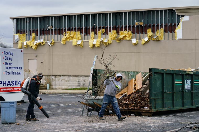
The winds picked up picnic benches and tables at the Texas Roadhouse restaurant and hurled them “a few hundred feet,” smashing windows at a shuttered restaurant in Montgomeryville, Montgomery County.
They “shook and tossed” several cars and tore off siding from a building, the National Weather Service said.
On Tuesday the agency determined that indeed it was a tornado that hit the Montgomery County community on Monday during an impressive outbreak of severe weather. That followed a morning of soaking rains from a particularly potent storm powered by cold air aloft and quite warm air at the surface.
And encores are possible, said Bill Bunting, chief of forecast operations at the government’s Storm Prediction Center, in Norman, Okla. “It’s an active pattern,” he said, adding that “similar setups” are possible during the next few weeks.
» READ MORE: Meteorologists, trends — and history — argue for a sixth straight cold shoulder from winter in Philly
Another significant storm, this one possibly blowing up somewhere along the East Coast on Friday night, could set off a slow-moving nasty rainstorm lasting well into the weekend, with perhaps snow in the Poconos.
However, it should behave quite differently from the one Monday that spawned the Montgomeryville twister.
The tornado touched down near Route 309 at the Route 202 northbound on-ramp at 3:47 p.m., then traveled about a half mile, cutting a 100-yard-wide path, said Trent Davis, a weather service meteorologist in Mount Holly.
It was rated an EF0, the weakest category, on the Enhanced Fujita scale, with peak winds at 70 mph.
As it weakened, it caused some minor damage to the Costco building, but no injuries or deaths were reported.
The weather service on Monday reported that radar had identified another tornado near Dover, Del., however it had not yet been confirmed.
The region has experienced tornadoes in November, and even in January and February, though they are more native to spring and summer, when the sun-heated ground provides energy for storms.
But they have occurred out of season around here, as on Halloween night last year.
» READ MORE: Storms disrupt SEPTA rail service; EF-2 tornado damages dozens of homes in Delco
Thunderstorms result from warm air rising over colder air, and this time of year the warmer air is more likely to get its lift from colder air aloft rather than being launched from the sun-baked ground, Bunting said. That’s why thunder and lightning sometimes occur during snowstorms.
Bunting said the Storm Prediction Center saw trouble Monday in a cold pool of air in the upper atmosphere associated with an intense storm that was moving across the Tennessee Valley toward southeastern Canada.
Winds circulate counterclockwise around storm centers. In Detroit it was snowing, while on the east side warming winds from the south sent Philadelphia temperatures rocketing into the 60s.
It “pulled up a lot of mild air really quickly,” said Dean Iovino, lead meteorologist with the weather service’s Mount Holly office.
By 1 p.m., the storm center had seen enough of the potential and issued a tornado watch for the entire region.
» READ MORE: Most warnings are false alarms, but tornado watches get attention — with good reason
Even before the thunderstorms, several 50 mph gusts were reported, and soaking rain had fallen. The thunder and lightning were accompanied by flooding downpours, and Davis said that it appeared that clusters of thunderstorms picked on Southeastern Pennsylvania.
The weather service reported rain totals in the 3-inch range in parts of Philadelphia’s Pennsylvania collar counties, with 3.4 inches in Villanova.
The agency also logged dozens of reports of downed trees on both sides of the river and in Delaware.
Things should dry out the next two days with December-like highs in the 40s, then conditions deteriorate.
Lake-effect snows are creaming parts of Pennsylvania, New York, and Ohio, but no snow is expected around here in the near future, just a rather unpleasant weekend.
