Ida remnants spawn tornadoes, deluges, and flash floods in Philly region. Significant river flooding is next
In all, the National Weather Service issued 14 tornado warning for the Philly region.
A home is missing its roof, damaged by a possible tornado on the corner of Josephine and Marvin Lanes in Mullica Hill, Harrison Township, Sept. 1, 2021.Read moreTOM GRALISH / Staff Photographer
Ida’s moisture-laden remnants evidently spawned multiple tornadoes throughout the region in an hours-long siege Wednesday, ripping off roofs, uprooting trees, and snapping utility poles. And the storm that also set off road-closing downpours isn’t quite done with us.
Forecasters are warning that the Philadelphia region could experience its most robust river flooding in a decade during the next two days. Late Wednesday night, floodwaters swamped Columbus Boulevard as the Delaware River rose nearly 1.5 feet above flood stage.
Clouds from Hurricane Ida encompass Philadelphia around 7:30 pm on Sept. 1, 2021.Read moreELIZABETH ROBERTSON / Staff Photographer
Homes damaged from the remnants of Hurricane Ida on Josephine Lane in Mullica Hill, N.J. on Thursday, September 2, 2021.Read moreMONICA HERNDON / Staff Photographer
Troy Bonnenberg picks at something in the ground near his damaged home on Marvin Lane in Mullica Hill, N.J. on Thursday, September 2, 2021. Remnants of Ida moved through the Philadelphia area Wednesday into Thursday, bringing heavy rain and widespread flooding. Multiple tornadoes were confirmed in the region.Read moreMONICA HERNDON / Staff Photographer
Homes damaged from the remnants of Hurricane Ida on Josephine Lane in Mullica Hill, N.J. on Thursday, September 2, 2021.Read moreMONICA HERNDON / Staff Photographer
Homeowner Ashley Thomas hugs a neighbor in front of her damaged home on Marvin Lane in Mullica Hill, N.J. on Thursday, September 2, 2021. Remnants of Ida moved through the Philadelphia area Wednesday into Thursday, bringing heavy rain and widespread flooding. Multiple tornadoes were confirmed in the region.Read moreMONICA HERNDON / Staff Photographer
Governor Phil Murphy speaks to the media in front of homes with significant damage from a tornado on Marvin Lane and Josephine Lane in Mullica Hill, N.J. on Thursday, September 2, 2021. Remnants of Ida moved through the Philadelphia area Wednesday into Thursday, bringing heavy rain and widespread flooding. Multiple tornadoes were confirmed in the region.Read moreMONICA HERNDON / Staff Photographer
A woman moves through the second story of a home with significant damage from a tornado on Marvin Lane and Josephine Lane in Mullica Hill, N.J. on Thursday, September 2, 2021. Remnants of Ida moved through the Philadelphia area Wednesday into Thursday, bringing heavy rain and widespread flooding. Multiple tornadoes were confirmed in the region.Read moreMONICA HERNDON / Staff Photographer
Family members embrace in front of homes with significant damage from a tornado on Marvin Lane and Josephine Lane in Mullica Hill, N.J. on Thursday, September 2, 2021. Remnants of Ida moved through the Philadelphia area Wednesday into Thursday, bringing heavy rain and widespread flooding. Multiple tornadoes were confirmed in the region.Read moreMONICA HERNDON / Staff Photographer
A child peeks into a home damaged from the remnants of Hurricane Ida on Josephine Lane in Mullica Hill, N.J. on Thursday, September 2, 2021.Read moreMONICA HERNDON / Staff Photographer
Flooding can be seen from the Manayunk Bridge, with everything between I-76 on the right and Main Street on the left submerged Thursday, Sept. 2, 2021.Read moreJUSTINE MCDANIEL / Staff
A residents surveys the scene along N. Croskey Street near Cherry Street. Heavy rain from Hurricane Ida is creating problems with flooding in Philadelphia and region on Thursday, September 2, 2021.Read moreALEJANDRO A. ALVAREZ / Staff Photographer
A flooded parking lot on S. 24th Street as seen from Walnut Street. Heavy rain from Hurricane Ida is creating problems with flooding in Philadelphia and region on Thursday, September 2, 2021.Read moreALEJANDRO A. ALVAREZ / Staff Photographer
A couple of women watch as a tow truck works to remove a car from flood water on N. 23rd near Race St. Heavy rain from Hurricane Ida is creating problems with flooding in Philadelphia and region on Thursday, September 2, 2021.Read moreALEJANDRO A. ALVAREZ / Staff Photographer
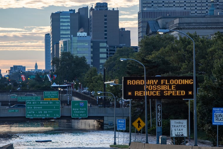
Sign informs motorists that there could be flooding on Vine Street expressway. Heavy rain from Hurricane Ida is creating problems with flooding in Philadelphia and region on Thursday, September 2, 2021.Read moreALEJANDRO A. ALVAREZ / Staff Photographer
Cars cross flooded intersection of Arch Street at 22nd Streett. Heavy rain from Hurricane Ida is creating problems with flooding in Philadelphia and region on Thursday, September 2, 2021.Read moreALEJANDRO A. ALVAREZ / Staff Photographer
A tow truck works to remove a car from flood water on N. 23rd near Race St. Heavy rain from Hurricane Ida is creating problems with flooding in Philadelphia and region on Thursday, September 2, 2021.Read moreALEJANDRO A. ALVAREZ / Staff Photographer
I-676 the Vine Street expressway is underwater. Heavy rain fell over Philadelphia and region Wednesday into Thursday. The areas near the banks of Schuylkill River and in Manayunk are flooding. Photograph from Thursday morning September 2, 2021.Read moreALEJANDRO A. ALVAREZ / Staff Photographer
A view of Lincoln Drive from Henry Avenue bridge. Heavy rain from Hurricane Ida is creating problems with flooding in Philadelphia and region on Thursday, September 2, 2021.Read moreALEJANDRO A. ALVAREZ / Staff Photographer
A view of Main Street Manayunk as seen from Shurs Lane. Heavy rain from Hurricane Ida is creating problems with flooding in Philadelphia and region on Thursday, September 2, 2021.Read moreALEJANDRO A. ALVAREZ / Staff Photographer
A view of the rising Schuylkill River, caused by Hurricane Ida, at the Market St bridge in Phila., Pa. shortly after 3 am on Sept. 2, 2021.Read moreELIZABETH ROBERTSON / Staff Photographer
Phila. firefighters stop a USPS tractor trailer from driving down N 23rd St at Race St. in Phila. Pa. just before 5 am Sept. 2, 2021. Flooding from Hurricane Ida is causing major flooding around the Phila. area.Read moreELIZABETH ROBERTSON / Staff Photographer
Flooding from Hurricane Ida makes the Vine St. Expressway near 22nd St. impassable around 4:20 am on Sept. 2, 2021.Read moreELIZABETH ROBERTSON / Staff Photographer
A man watches an angry Schuylkill River from the John F Kennedy Blvd entrance to the Schuylkill River Trail in Phila., Pa. just after 3 am on Sept. 2, 2021.Read moreELIZABETH ROBERTSON / Staff Photographer
Traffic along I-76 heading into Center City just before turn off for I-676. Heavy rain from Hurricane Ida is creating problems with flooding in Philadelphia and region on Thursday, September 2, 2021.Read moreALEJANDRO A. ALVAREZ / Staff Photographer
Part of a structure floats down Main Street at Shurs Lane in Manayunk. Heavy rain from Hurricane Ida is creating problems with flooding in Philadelphia and region on Thursday, September 2, 2021.Read moreALEJANDRO A. ALVAREZ / Staff Photographer
Damage at Upper Dublin High School Thursday, Sept. 2, 2021, a day after Ida passed through the region.Read moreHEATHER KHALIFA / Staff photographer
People walk past heavy damage to Upper Dublin High School in Fort Washington, Pa. on Thursday, Sept. 2, 2021. The region is continuing to deal with fallout after the remnants of Hurricane Ida tore through Wednesday evening, causing flooding and heavy damage.Read moreHEATHER KHALIFA / Staff Photographer
People take in the damage behind Upper Dublin High School in Fort Washington, Pa. on Thursday, Sept. 2, 2021. The region is continuing to deal with fallout after the remnants of Hurricane Ida tore through Wednesday evening, causing flooding and heavy damage.Read moreHEATHER KHALIFA / Staff Photographer
People walk underneath the Fort Washington Expressway on Loch Alsh Ave. and toward Upper Dublin High School where homes and schools were damaged from last night’s storm in Fort Washington, Pa. on Thursday, Sept. 2, 2021. The region is continuing to deal with fallout after the remnants of Hurricane Ida tore through Wednesday evening, causing flooding and heavy damage.Read moreHEATHER KHALIFA / Staff Photographer
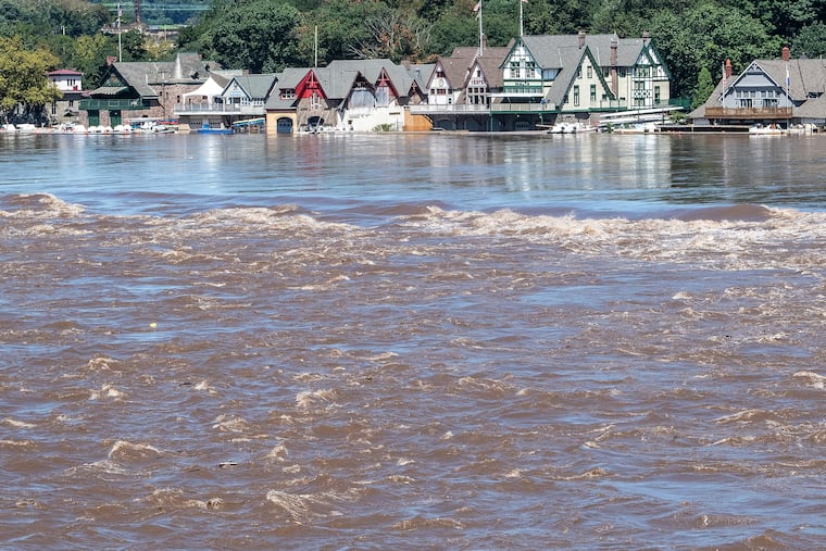
Boathouse Row is shown on Thursday, Sept. 2, 2021., a day after heavy storms and flooded waters from the Schuylkill River in Philadelphia, Pa.Read moreJOSE F. MORENO / Staff Photographer
Boathouse Row is shown on Thursday, Sept. 2, 2021., a day after heavy storms and flooded waters from the Schuylkill River in Philadelphia, Pa.Read moreJOSE F. MORENO / Staff Photographer
Andrew Solimeo, 30, of Downingtown, Pa., and his girlfriend, Morgan Bonsall, 29, of Downingtown, Pa., are cleaning out the first floor of their home along Brandywine Avenue in Downingtown, Pa., on Thursday, Sept., 2, 2021. Solimeo and Bonsall left their home with their two cats and dogs on their shoulders as they cross the street to their neighbors house. The water levels were about five feet high.Read moreTYGER WILLIAMS / Staff Photographer
People look over parking lot at the Pointe at Phoenixville Riverworks in Phoenixville with flooding the French Creek, Thursday, September 2, 2021Read moreSTEVEN M. FALK / Staff Photographer
The Montgomery County coroner removes a victim of the storm from a house on 3rd Street in Bridgeport. The victims' house is located about 200 yards from the Schuylkill River, Thursday, September 2, 2021Read moreSTEVEN M. FALK / Staff Photographer
Trying for a better view people under the Conrail trestle in Phoenixville on Main Street Rt.29 looking towards Mont Clare with a car under water from flooding along the Schuylkill river, Thursday, September 2, 2021Read moreSTEVEN M. FALK / Staff Photographer
Lorraine Geiling, 61, of Downingtown, Pa., looks into the first floor of an apartment she is leasing that was flooded last night along Manor Ave., and E Lancaster Ave., in Downingtown, Pa., on Thursday,Sept., 2, 2021. “This is really devastating,” Geiling said. “Never had water in my first floor apartment. I don’t have any flood insurance. I don’t have the money to pay for this. This is my lively hood.”Read moreTYGER WILLIAMS / Staff Photographer
A home is missing its roof, damaged by a possible tornado on the corner of Josephine and Marvin Lanes in Mullica Hill, Harrison Township, Sept. 1, 2021.Read moreTOM GRALISH / Staff Photographer
An officer inspects a home without a roof, damaged by a possible tornado on Marvin Lane in Mullica Hill, Harrison Township, Sept. 1, 2021.Read moreTOM GRALISH / Staff Photographer
A home damaged by a possible tornado on Josephine Lane in Mullica Hill, Harrison Township, Sept. 1, 2021.Read moreTOM GRALISH / Staff Photographer
A home damaged by a possible tornado on the corner of Josephine and Marvin Lanes in Mullica Hill, Harrison Township, Sept. 1, 2021.Read moreTOM GRALISH / Staff Photographer
The rear window of a car is damaged by a possible tornado on Josephine Lane in Mullica Hill, Harrison Township, Sept. 1, 2021.Read moreTOM GRALISH / Staff Photographer
Butler Pike near Morris Rd. is shut down in Montgomery County on Sept. 1, 2021. Two submerged vehicles are in the background.Read moreCHARLES FOX / Staff Photographer
“We’ll probably have a lot of it,” said Sarah Johnson, a lead meteorologist at the National Weather Service Office in Mount Holly. The Delaware River was forecast to crest late Friday close to the moderate flood level at Trenton.
“Major” flooding levels were measured late Wednesday night along the Schuylkill at Norristown and in Philadelphia. At 30th Street, the Schuylkill was forecast to rise more than 10 feet above flood stage Thursday morning at the government’s newly installed monitoring gauge.
In New Jersey, Gov. Phil Murphy declared a state of emergency.
As night progressed, school cancellations grew. Norristown Superintendent Christopher Dormer said that schools would be closed Thursday. Even virtual classes were canceled. Cheltenham canceled classes, and schools also will be closed in the Central Bucks School District. Also in Bucks County, the Centennial School District canceled in-person instruction Thursday but said students would be expected to log on for virtual schooling.
No evacuations were planned, but along the Schuylkill in West Norriton Township, historicaly one of the more flood-prone communities in the nation, officials had set up a shelter at Norristown Area High School, said Jason Bobst, the township’s emergency director.
Philadelphia also was set to open shelters in West Philadelphia and Roxborough “out of an abundance of caution,” said Fire Commissioner Adam Thiel.
“This is expected to be a pretty severe flooding event,” said Thiel.
Save for that river flooding, Thursday and Friday actually should be quite pleasant early September days with sunshine and temperatures in the 70s, a remarkable and welcome contrast to an afternoon and night of chaos and jumpy, indefatigable cellphone alarms. About 40,000 Peco customers lost power.
Stream and road flooding was widespread, and for a solid three hours starting about 4:15 p.m., the region became Tornado Alley east. The weather service issued 14 tornado warnings for the region from deep southwestern Chester County to Mullica Hill, Gloucester County. Tornadoes already are well above normal this year in Pennsylvania and New Jersey.
A Severe Storm just came through Southern Chester County. Several trees are down and roads are closed. If you do not have to go out, DON’T. pic.twitter.com/hRZwh636jL
The weather service said it had radar-confirmed two of the tornadoes, and the one that struck Mullica Hill almost certainly will be verified when weather service teams inspect the damages.
Ellen Capriotti, 50, a teacher at Clearview Regional High School who lives on Forest Woods Drive in a development called The Enclave at Forest Woods, said she and her husband, Dave, and two of their children were waiting for a pizza delivery when they heard the approaching winds.
“It became, ‘Grab the dog and go down into the basement,’ ” she said. “Things were hitting the house. I was talking to my daughter and she was answering me, but I couldn’t hear what she was saying. ... A neighbor had a tree go through their front door. Thank God my family and I are OK.”
One of the radar-confirmed tornadoes was a “large and extremely dangerous tornado” near Willow Grove, Montgomery County, late in the afternoon. The roofs were blown off several buildings along Norristown Road in Horsham Township, the weather service reported.
About two hours later, shortly after 7, it confirmed a “large and destructive” one in southeastern Bucks County, and a trained spotter in Tullytown said it skipped across the river to adjacent South Jersey.
Reports of tornado-like damage came from other places, including the area around Cherry Hill, where multiple trees and wires were ripped down, and that, too, might have been a tornado, the weather service said.
In short, on an afternoon and evening of atmospheric bedlam, the weather service was inundated with storm reports.
Besides the suspected twisters, late-day downpours put an unwanted Venetian touch on some local roads.
“We have a lot of roads closed in Bucks and Chester,” said Brad Rudolph, a PennDot spokesperson. Among them were portions of Route 1 in Bucks County and the heavily used Route 30 Bypass near Route 113 in Chester County.
Numerous other road closings were reported throughout the region.
The rain potential was well forecast, the “T” word was mentioned as a possibility, particularly for areas south and east of Philadelphia. However on Wednesday, the danger zone expanded well to the north and west, all the way to the Lehigh Valley.
The core of Ida’s leftovers passed west of the region, and in the case of tropical storms and their remnants, areas to the east of the center become most vulnerable for tornadoes, said the weather service’s Johnson.
“There’s so much spin involved,” said Dave Dombek, senior meteorologist with AccuWeather Inc. While land surfaces and trees cause friction that reduces a storm’s wind speeds, he said, “It’s still churning at mid and upper latitudes.”
In this case, Ida’s moisture was getting a lift from upper-air winds and a stalled front that were conspiring to wring out moisture.
Given the forecasts, all morning New Jersey and Pennsylvania officials had urged people to stay home.
“Imagine a month, two months of rain in 24 hours,” Jeff Jumper, meteorologist with the Pennsylvania Emergency Management Agency, said at a news briefing.
Coatesville, Chester County, reported better than 8 inches of rain.
Upstream rains also were a concern for the main stem rivers.
Sometime Friday the Delaware River at Trenton is predicted to crest near the “moderate” flooding level at 22.6 feet, which would be the highest level since the river was swollen by Hurricane Irene’s remnants in August 2011. Flood stage is 20 feet.
Columbus Blvd by the Ben Franklin Bridge is underwater and the road closed to traffic as #Ida remnants cause major flooding. The Delaware River is expected to reach its highest water level in 10 yrs & multiple tornadoes were confirmed in the Philly region: https://t.co/csZ6yvD8kHpic.twitter.com/DdJw4U4l9q
The Delaware experienced significant flooding in 2004, 2005, and 2006, but in the last 10 years for whatever reasons it has been remarkably well-behaved despite any number of downpours.
Ice jams sent the waters just above flood stage in January 2014, but it hasn’t reached the 20-foot level since.
Late Wednesday night, major flooding levels were reported at multiple locations, including Neshaminy Creek near Langhorne, Perkiomen Creek at Graterford, East Branch Brandywine Creek near Downingtown, and Brandywine Creek at Chadds Ford. Moderate flooding was reported in multiple other locations along the Delaware River, up through Easton.
No more rain will be added to the waterways around here at least until late next week. And no tornadoes; some might say, like the good old days.
Said Thiel, the fire commissioner, “There used to be a time when we thought tornadoes didn’t happen in Philadelphia.”
Staff writers Melanie Burney, Kristen A. Graham, Maddie Hanna, Frank Kummer, Andy Maykuth, Kevin Riordan, and Ellie Rushing contributed to this article.
I am a staff writer and a weekend editor. I write about a variety of subjects, but most often about the neighborhood where we all live — the atmosphere.