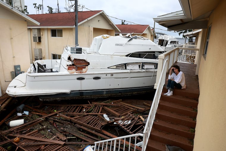
Ian’s heavy rains, with strong winds at the Shore, are expected in the Philly region this weekend
Strong onshore winds that could persist into the middle of next week could cause considerable beach erosion. Minor flooding along the Delaware and Schuylkill rivers is also possible.

Tropical-storm-force gusts and up to 4 inches of Ian-related rains are possible Friday night into Saturday at the Jersey Shore, and strong onshore winds that are due to continue into the middle of next week could rip considerable sand off the beaches.
Minor flooding also is a threat along the Delaware and Schuylkill Rivers.
But based on all the clues the atmosphere was willing to offer about Ian’s strange and destructive career, what most of the Philadelphia region will experience this weekend would qualify as a rainstorm attached to a name, with perhaps 1 to 2 inches along I-95.
» READ MORE: Ian's "cone of certainty" underwent quite a few changes
“It looks like the heaviest rain is going to stay well south of the city,” said Sarah Johnson, warning coordination meteorologist at the National Weather Service Office in Mount Holly.
Ian’s odyssey
After tormenting Florida with several days of high anxiety followed by tornadic winds, flooding storm surges, and its rains of terror, Ian was downgraded to a tropical storm before it popped off the east-central Florida coast Thursday and regained hurricane strength.
The National Hurricane Center said at 11:15 p.m. that Ian’s peak winds were at 85 mph and that it was due to make another landfall, this one on the South Carolina coast, sometime Friday. Then it was to arc toward the Blue Ridge Mountains on Saturday.
» READ MORE: Many trapped in Florida as Hurricane Ian heads toward South Carolina
Even though it was expected to lose its tropical identity, and its center was forecast to come no closer than 350 miles to Philadelphia on Saturday, it would begin to affect the region Friday night, forecasters said.
“Its moisture is going to surge up the coast,” said Paul Walker, senior meteorologist at AccuWeather Inc.
What to expect
Rain is forecast to creep into the region Friday night or early Saturday, and become heavy at times.
» READ MORE: Beach erosion and N.J.'s 100-year battle with the sea
The strongest winds, however, aren’t anticipated until Ian loses its identity, probably happening sometime Saturday night, according to the hurricane center’s track map.
What’s left of the original storm will take an eastward turn, merge with another system, and be due south of Philadelphia perhaps during the middle of next week, said Johnson.
“It’s going to meander,” she said.
The region will be caught in one of those air sandwiches as higher pressure, or heavier air, to the north interacts with the lower pressure, or lighter air, associated with Ian’s remains. (A standard image for that phenomenon is air from a punctured tire escaping into the atmosphere.) The winds will outlast the rains in all likelihood.
On the mainland, peak gusts on Sunday could top 25 mph and persist into Monday.
At the Shore, however, the winds will arrive sooner and be more potent, with onshore gusts past 30 mph or higher on Saturday. They might howl up to 45 mph on Sunday, and strong gusts could linger into Tuesday, with steady onshore breezes continuing into Wednesday.
That lengthy assault could lead to minor coastal flooding, said Johnson. The winds could inhibit drainage and lead to some minor tidal flooding along the Delaware and Schuylkill Rivers, she said.
Silver lining department
Whatever does happen, the impacts should be nothing like those of the sequence of tropical storm remnants that bedeviled the Philadelphia region during the 2020 and 2021 Atlantic hurricane seasons.
“It isn’t going to be Ida,” said Bryan Norcross, the veteran hurricane specialist at Fox Weather, a welcome assurance for all those around here who endured the record flooding and tornadoes wrought by last year’s “I” storm.
» READ MORE: Remembering Ida: Here is the timeline of destruction
Johnson seconded that observation. “I hesitate to compare it to any other system,” she said.
While it does have a strong case for uniqueness, Ian will share one trait with Ida.
Its name will be removed from the list that is recycled every six years, a distinction belonging only to the deadliest and most damaging storms.
