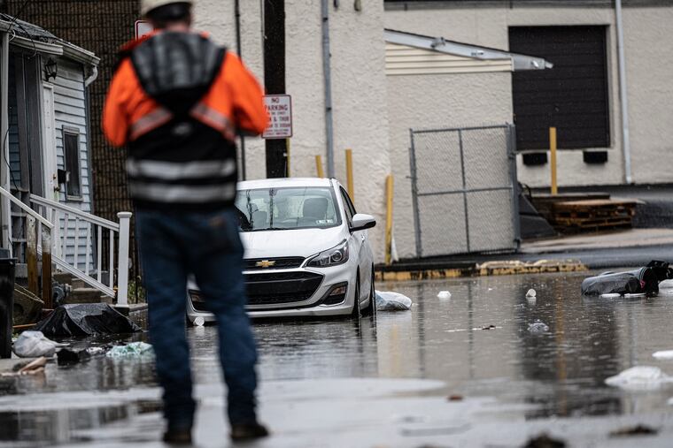
Philly’s flood threat could last ‘several days,’ and winds are likely to take down trees and power lines, forecasters warn
Flooding is expected along the Schuylkill and Delaware Rivers, with heavy rains falling upstream "in the worst possible places," a forecaster says.

The Philadelphia region is about to experience one of its more impressive winter rainstorms in the period of record, forecasters say, and given the behavior of the atmosphere since Dec. 1, the timing couldn’t be much worse.
The National Weather Service has posted a flood watch for most of Pennsylvania and all of New Jersey and Delaware for Tuesday into Wednesday.
“We’re going to be looking for this problem to last several days” in the Philadelphia region, said Ray Martin, a lead meteorologist at the weather service office in Mount Holly. Atop everything else, the moon is entering the “new” phase, which will give an extra kick to the tides.
For now, the Philly flood watch is in effect Tuesday afternoon into Wednesday afternoon. Minor flooding is expected along the Delaware River at Washington Avenue late Tuesday night, and moderate flooding around noon Wednesday. At least minor flooding is likely all long the Schuylkill, said Martin.
In addition, a high-wind advisory is up for the region from 5 p.m. Tuesday to 3 a.m. Wednesday for sustained winds up to 35 mph and gusts to 55, and a wind warning has been posted for the Shore for winds up to 45 mph and gusts to 65.
With the ground saturated, some trees are likely to come down, and take power lines with them.
“It’s not going to take much,” said Martin. “It’s going to be a very wet storm, and we already have a lot of water to deal with. It’s a bad situation.”
Gov. Phil Murphy announced that New Jersey would open its emergency operations center at noon Tuesday, and Peco and Atlantic City Electric officials said they had emergency plans in effect.
Said Peco spokesperson Brian Ahrens, “We definitely see the potential.” However, both he and Atlantic Electric spokesperson Candace Womer cautioned that outage-causing winds also can impede restorations. They said crews can’t use their bucket trucks if winds reach 30 mph.
Storm timing
Rains crept into the region at midmorning and are expected to intensify Tuesday night with powerful southeast and south winds.
Along with downpours, that could result in some tidal flooding along the Delaware in the city, said Martin, as winds push Delaware Bay waters northward.
The rains could set off short-term flash flooding along local streams, he said, but the response along the Schuylkill and the Delaware will be more complicated, with the effects longer-lasting.
Flooding along both rivers could be further juiced by the conditions in the vicinity of their headquarters where they have been mighty wet — and mighty white during the weekend.
The saturated ground
Several inches of snow fell recently in Schuylkill County, Pa., the home of the Schuylkill headwaters, and in Delaware County, N.Y., where the Delaware starts.
The warming winds and moisture from this week’s storm will result in snow melt, adding an additional half inch or so to the runoff up that way, said Bill Gartner, weather service meteorologist in State College, where the agency’s Middle Atlantic River Forecast Center is based.
» READ MORE: Philly is one of the more vulnerable locations for extreme rains
Precipitation in Philly, its surrounding counties, and throughout the rivers basins has been well above normal in the last 30 days.
Ominously, the bull’s-eye for rainfall, up to 4 inches, perhaps a splash more, could be in the hills of northeastern Pennsylvania near the upper Delaware, said Martin.
“It looks like it’s going to be in some of the worst possible places,” said Martin. “It’s a lot of water that’s going to be coming down the river.”
Why all the rain?
Since Dec. 1, officially just over 9 inches of rain has been measured at Philadelphia International Airport, roughly the amount of water in eight feet of snow.
The recent storms have at least some relationship with the ongoing El Niño warming over thousands of miles of the tropical Pacific where sea-surface temperatures were about 3.5 degrees Fahrenheit above normal as of Monday, meteorologists say. The heating of the overlying air is expected to affect the rest of the U.S. winter as upper-air winds transport weather systems west to east.
» READ MORE: El Niño likely will mean big coastal storms this winter, forecasters say. It might even snow in Philly.
This week’s storm will be mining rich supplies of moisture from the Gulf of Mexico. Said Gartner, “The Gulf is open for business.”
The moisture has been abundant, but the cold air hasn’t been. It might turn significantly colder during the holiday weekend, forecasters say — but first yet another rainstorm is due late Friday into Saturday.
» READ MORE: The rains keep coming, and the snows keep staying away
