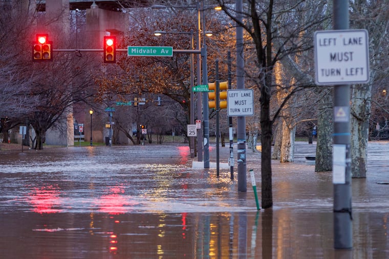
The Philly area is under yet another flood watch, and snow is possible next week
The snow threat for next week is real, meteorologists say. It also is early, and computer models have been all over the place.

Significant, disruptive flooding is all but a certainty along the Delaware River on Saturday and more power outages are likely, but it appears that this weekend, a remarkably wet period is going to yield to something we used to call winter around here.
Temperatures may not get above freezing in Philly Monday, and the region could even see enough snow to measure come Tuesday, but in that term, the region will be contending with yet another round of potent gusts and the aftermath of a second major soaking in a week.
Forecasts called for up to 1.5 inches rain in about a five-hour periods starting late Friday night. And while that would fall short of the drenching totals of Tuesday and Wednesday, they would be building upon the rainy legacy of the last six weeks that have left the streams restless and the ground saturated.
» READ MORE: As the storm cleanup continues in the Philly region, a windy, soggy encore looms. Then, winter?
Burlington County, where severe flooding resulted in water rescues and damage to more than 50 homes in Delran earlier this week, declared a state emergency. It advised residents who live in areas inundated earlier in the week to evacuate voluntarily. A Red Cross shelter was set up at the Delran firehouse. The Delaware River reached a record crest at Burlington Wednesday, and is forecast to reach “major” flooding levels late Saturday afternoon.
This is yet another storm cutting to the Great Lakes, putting the Philly region and the I-95 corridor on the warm side of the storm. Temperatures Saturday morning were forecast to top out in the 50s, before falling.
The flooding threats will persist Saturday along with potent winds, perhaps up to 60 mph at the Shore, but the rest of the day will be dry, and chances are excellent that the weather drumbeat will turn its undivided attention toward the pending snow threat.
“We’re already getting calls about that,” said Eric Hoeflich, meteorologist at the National Weather Service Office in Mount Holly. He added that the agency might put out its first snowfall forecast maps as early as Saturday. On Friday afternoon, it saw a 60% chance of up to 2 inches of snow, and a 33% shot at 6 inches or more.
A social-media flurry began earlier this week, and expect an all-out blizzard of outsized expectations, anxieties, flip-flops, and frustrations during the Martin Luther King holiday weekend, with a potential for swelling crowds at your favorite food store.
» READ MORE: The storm earlier this week saturated the ground and filled streams with 2-4 inches of rain
The flooding and wind threats
A flash flood watch was up until 7 a.m. Saturday, the result of rain falling into streams and upon the spongy ground that hasn’t had a chance to wring out completely.
Separately, the weather service has posted a warning for tidal flooding along the Delaware River until 7 p.m. Saturday, with minor flooding around 3 a.m., and road-sloshing moderate flooding 12 hours later. The tidal waters would be getting a nudge from the moon, which is just moving out of its “new” phase.
As for power outages, like most of us, the trees have about had it with this weather, and their limbs and saturated roots will be tested again Saturday, the weather service says. With sustained winds of up to 35 mph anticipated Saturday, and gusts to 55 mph, it’s likely that some folks are to lose power.
The snow threat
It is real, meteorologists say. It also is early, and computer models have been all over the place.
One thing is certain: It’s going to be cold enough when the precipitation would arrive, probably late Monday night or early Tuesday.
On Friday, winter-storm warnings were up in places from Oregon to upstate New York, and there was profoundly cold air in the central United States. Temperatures are predicted to sink below zero in Kansas City during the playoff game between the host Chiefs and Miami Dolphins on Saturday. Readings in Corpus Christi, Texas, are forecast to drop to the upper 20s early Tuesday and Wednesday. Some of that is pressing eastward.
In Philly, a rapid cooldown is forecast after the rains stop Saturday, with some inconsequential snowflakes Sunday night.
As opposed to the recent sequence of “cutters” that plowed their way toward the Great Lakes, the next storm may develop off the Atlantic Coast.
» READ MORE: It's been almost two years since Philly had an inch of snow. Will the streak end Tuesday?
Winds circulate counterclockwise around centers of low pressure, thus, when storms pass northwest of Philly, the region experiences warming winds from the south. Conversely, when they pass to east, the winds are from a more northerly and northeasterly direction, thus, the term “nor’easter.”
In the way-too-early going, computer models were seeing everything from a blockbuster snowstorm to a continuation of the Philly’s historic snowless streak.
“Some of the models don’t really do much with it, and push it off shore without any fanfare,” said Tom Kines, senior meteorologist with AccuWeather Inc.
“There are some models that strengthen it, bring it up the coast, and give us a decent amount of moisture.”
He added, that if the storm tracked too close to the coast, or even inland, it could draw warm air above the Atlantic and turn the rain to snow.
It is safe to assume that during the weekend, computer models will be showing all these possibilities and have a hard time agreeing with each other, and themselves.
Stay tuned.
