With a forecast of temperatures flirting with 100 and heat index values up to 110, the fourth day of the heat wave dawned ominously on Monday, with Philadelphia tying a record for highest minimum temperature — 81 — for the date.
“When we came in and saw that,” said Jonathan O’Brien, a Monday day shift meteorologist at the National Weather Service office in Mount Holly, forecasters concluded that “it looks like it’s going to be as expected.”
Gary Reid cools off under a fire hydrant at Lehigh Avenue and Lawrence Street in Philadelphia, Pa. on July 20, 2020.Read moreDAVID MAIALETTI / Staff Photographer
Albert Wellstein of Old City stays cool in the Adirondack chairs in the shade in Franklin Square July 20, 2020 as the city was really hot, but did not make it into temperatures in the upper 90s - or 100 degrees as predicted.Read moreTOM GRALISH / Staff Photographer
Amina Jones, age-11, of Philadelphia, beats the heat at the re-open Love Park fountain during a hot summer day in Philadelphia, Pa. Monday, July 20, 2020. A heat advisory has been issued for the city of Philadelphia.Read moreJOSE F. MORENO / Staff Photographer
Keith Scutching of Center City stays cool in the shade of Franklin Square watching the fountain show July 20, 2020. The choreographed fountain show debuted last summer, with shows featuring dancing water, LED lights and music. Performances take place every 30 minutes from noon to 9 p.m. daily through the month of July.Read moreTOM GRALISH / Staff Photographer
Merion Martinez cooling off under a fire hydrant at Lehigh Avenue and Lawrence Street in Philadelphia, Pa. on July 20, 2020.Read moreDAVID MAIALETTI / Staff Photographer
Boaters ride on the Delaware River near the Navy Yard in South Philadelphia on Sunday, July 19, 2020.Read moreYONG KIM / Staff Photographer
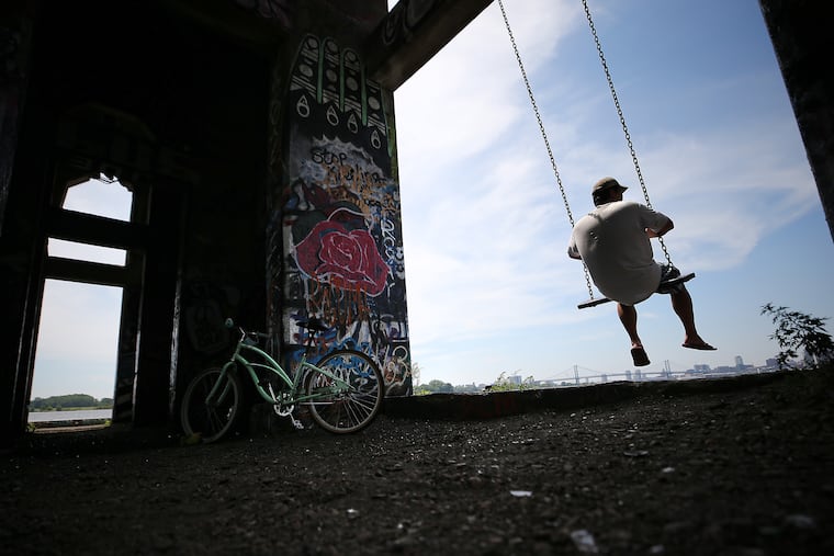
A visitor to Graffiti Pier, who didn’t want to give his name, cools off on a swing on the pier in Philadelphia, Pa. on July 19, 2020. The forecast for Monday has the temperature climbing into the upper 90’s.Read moreDAVID MAIALETTI / Staff Photographer
An American Water Co. employee turns off a fire hydrant that someone turned on at 5th and Elm in Camden, N.J. on July 18, 2020. The worker said this particular hydrant, that was found open and unattended, can lose 500 gallons of water a minute.Read moreELIZABETH ROBERTSON / Staff Photographer
Because of the coronavirus (COVID-19) pandemic, the Swann Memorial Fountain in Logan Circle has not been filled with water and offers no relief from the blistering heat in Phila., Pa. on July 19, 2020.Read moreELIZABETH ROBERTSON / Staff Photographer
Star Aponte, 4, (right), and her twin sister Luz Aponte, 4, (left), play in a swimming pool together in front of their home in Feltonville Philadelphia, on Saturday, July 18, 2020.Read moreTYGER WILLIAMS / Staff Photographer
At a backyard summer party, near 6th and Cecil B. Moore Sts., Aubrey makes a big splash as she comes down an inflatable slide on July 18 2020. Temperatures climbed into the 90’s.Read moreCHARLES FOX / Staff Photographer
A woman sits in the mist of a spraying fire hydrant to keep cool at 5th and Dauphin Streets on July 18 2020.Read moreCHARLES FOX / Staff Photographer
Marco Rosario (right) lowers his dog Fremont in the swimming pools at Schuylkill River Park on July 18 2020 as his daughter, Natalie looks on. Ruby is the other dog. Temperatures climbed into the 90’s. The pools are in one of the dog exercise areas.Read moreCHARLES FOX / Staff Photographer
At a backyard summer party, near 6th and Cecil B. Moore Sts., Kennedi Fletcher, 2, enjoys herself in a pool on July 18 2020. Temperatures climbed into the 90’s.Read moreCHARLES FOX / Staff Photographer
At a backyard summer party, near 6th and Cecil B. Moore Sts., a young girl makes her way down an inflatable slide on July 18 2020. Temperatures climbed into the 90’s.Read moreCHARLES FOX / Staff Photographer
A car uses a sraying fire hydrant at 5th and Dauphin Street to get a quick wash on July 18 2020. Temperatures climbed into the 90’s.Read moreCHARLES FOX / Staff Photographer
A hot cyclist uses a towel for shade as he makes his way through Logan Circle on July 18 2020. Temperatures climbed into the 90’s.Read moreCHARLES FOX / Staff Photographer
A group of women who declined to give their names sun bathe at Schuylkill River Park on July 18 2020. Temperatures climbed into the 90’s. Braving the hot temperatures was better than the alternative of staying inside they said. “Plus you get a tan.”Read moreCHARLES FOX / Staff Photographer
Aubrey Huberty of Philadelphia cools off in the children’s sprinkler area of Twin Cities Park on July 18 2020. Temperatures climbed into the 90’s.Read moreCHARLES FOX / Staff Photographer
Christine Embon, 56, from Philadelphia enjoys the day in the shade at FDR Park in her hammock reading a book. Friday, July 17, 2020Read moreSTEVEN M. FALK / Staff Photographer
Malachi Armstrong, (right), and Ericka Armstrong, (left), are with their daughter Aaliyah Armstrong enjoying the weather along the Schuylkill River on Friday, July 17, 2020.Read moreTYGER WILLIAMS / Staff Photographer
Liz Dipre, 26, of Center City, owner of Aqua Vida, (right), is out paddle boarding with her best friend Marissa Dotzler, 27, of South Philadelphia, (left), enjoying the weather in the Schuylkill River on Friday, July 17, 2020.Read moreTYGER WILLIAMS / Staff Photographer
But in this case, the atmosphere had a mildly pleasant surprise in store. After climbing to 92 degrees by 11 a.m., the temperature surprisingly backed off to 90 at Philadelphia International Airport an hour later, and west winds gusted to 21 mph. More significantly, the noon heat index was 93; the forecast for noon had been 105.
It warmed up to 96, and the heat index made it to 102 at 6 p.m., unmistakably hot, but three degrees below the heat-warning criterion, and well past the peak of the sun.
“The heat isn’t quite as extreme,” said Paul Walker, senior meteorologist at AccuWeather Inc. And looking ahead to the rest of the week, he said, the heat wave isn’t looking as ferocious as it had been.
But heat indexes could top 100 again on Wednesday, the weather service said, and might meet the “heat advisory” level.
The City of Philadelphia will continue its heat emergency through 11:59 p.m. Tuesday, and the Philadelphia Corporation for Aging will operate its heat “helpline” (215-765-9040) again Tuesday. It’s possible that the emergency will extend into Wednesday.
However, O’Brien said the week might pass without another weather service heat warning.
Early in the day, it appeared that hitting the warning criterion on Monday was all but a certainty. But around lunchtime, forecasters said, in response to an approaching frontal feature, some drier air mixed down from the upper atmosphere. That plus some mid-level cloudiness held the temperatures and the heat index to more bearable levels.
For those seeking asylum at the Shore, with a land breeze, the air was quite steamy, and the heat index made it to 104 at Atlantic City International Airport. Then again, folks in the beach towns did have access to the Atlantic Ocean.
Behind the front, Tuesday will be hot, with highs in the mid-90s, but heat index values are forecast to stay below 100. Wednesday, the discomfort level is due to increase, but showers are possible, and they might be more likely on Thursday, said Walker.
Temperatures might not make it to 90 on Friday and Saturday — not that the upper 80s would be polar vortex territory — and readings aren’t forecast to drop below 70 overnight for the rest of the week.
The lack of nighttime cooling allows dwellings without air-conditioning to heat up dangerously when the sun comes up, a particular hazard for the elderly who live alone.
In Philadelphia, Health Commissioner Thomas Farley advised relatives and neighbors to check on seniors by telephone or video, or to knock on doors — but while practicing the coronavirus protocols of wearing masks and keeping social distance.
I am a staff writer and a weekend editor. I write about a variety of subjects, but most often about the neighborhood where we all live — the atmosphere.