While the summer of 2020 appears to be on its way to being one of the warmer ones in the period of record in Philadelphia, so far the region has avoided the extreme heat that has baked other parts of the nation. But it looks like it’s our turn.
The National Weather Service warns that the next several days — particularly Monday, when the daytime high in Philadelphia could make a run at 100 for the first time in eight years — could be “dangerously hot” and that the heat wave could continue into next weekend.
“It’s going to be a just awful heat wave,” said Brett Rossio, a meteorologist with AccuWeather Inc. “You may even knock out 100.” Ironically, the only thing preventing that from happening would be all the moisture in the air, which will divert some of the sun’s energy but will drive up heat indexes. The record for the date is 99, set in 1930.
Gary Reid cools off under a fire hydrant at Lehigh Avenue and Lawrence Street in Philadelphia, Pa. on July 20, 2020.Read moreDAVID MAIALETTI / Staff Photographer
Albert Wellstein of Old City stays cool in the Adirondack chairs in the shade in Franklin Square July 20, 2020 as the city was really hot, but did not make it into temperatures in the upper 90s - or 100 degrees as predicted.Read moreTOM GRALISH / Staff Photographer
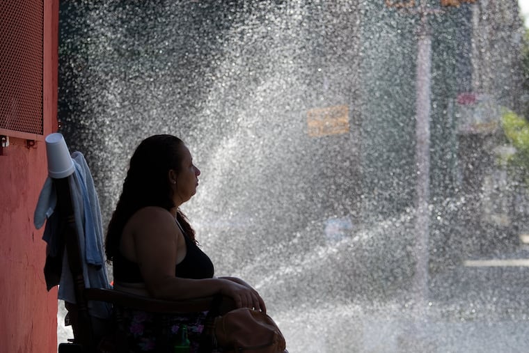
Amina Jones, age-11, of Philadelphia, beats the heat at the re-open Love Park fountain during a hot summer day in Philadelphia, Pa. Monday, July 20, 2020. A heat advisory has been issued for the city of Philadelphia.Read moreJOSE F. MORENO / Staff Photographer
Keith Scutching of Center City stays cool in the shade of Franklin Square watching the fountain show July 20, 2020. The choreographed fountain show debuted last summer, with shows featuring dancing water, LED lights and music. Performances take place every 30 minutes from noon to 9 p.m. daily through the month of July.Read moreTOM GRALISH / Staff Photographer
Merion Martinez cooling off under a fire hydrant at Lehigh Avenue and Lawrence Street in Philadelphia, Pa. on July 20, 2020.Read moreDAVID MAIALETTI / Staff Photographer
Boaters ride on the Delaware River near the Navy Yard in South Philadelphia on Sunday, July 19, 2020.Read moreYONG KIM / Staff Photographer
A visitor to Graffiti Pier, who didn’t want to give his name, cools off on a swing on the pier in Philadelphia, Pa. on July 19, 2020. The forecast for Monday has the temperature climbing into the upper 90’s.Read moreDAVID MAIALETTI / Staff Photographer
An American Water Co. employee turns off a fire hydrant that someone turned on at 5th and Elm in Camden, N.J. on July 18, 2020. The worker said this particular hydrant, that was found open and unattended, can lose 500 gallons of water a minute.Read moreELIZABETH ROBERTSON / Staff Photographer
Because of the coronavirus (COVID-19) pandemic, the Swann Memorial Fountain in Logan Circle has not been filled with water and offers no relief from the blistering heat in Phila., Pa. on July 19, 2020.Read moreELIZABETH ROBERTSON / Staff Photographer
Star Aponte, 4, (right), and her twin sister Luz Aponte, 4, (left), play in a swimming pool together in front of their home in Feltonville Philadelphia, on Saturday, July 18, 2020.Read moreTYGER WILLIAMS / Staff Photographer
At a backyard summer party, near 6th and Cecil B. Moore Sts., Aubrey makes a big splash as she comes down an inflatable slide on July 18 2020. Temperatures climbed into the 90’s.Read moreCHARLES FOX / Staff Photographer
A woman sits in the mist of a spraying fire hydrant to keep cool at 5th and Dauphin Streets on July 18 2020.Read moreCHARLES FOX / Staff Photographer
Marco Rosario (right) lowers his dog Fremont in the swimming pools at Schuylkill River Park on July 18 2020 as his daughter, Natalie looks on. Ruby is the other dog. Temperatures climbed into the 90’s. The pools are in one of the dog exercise areas.Read moreCHARLES FOX / Staff Photographer
At a backyard summer party, near 6th and Cecil B. Moore Sts., Kennedi Fletcher, 2, enjoys herself in a pool on July 18 2020. Temperatures climbed into the 90’s.Read moreCHARLES FOX / Staff Photographer
At a backyard summer party, near 6th and Cecil B. Moore Sts., a young girl makes her way down an inflatable slide on July 18 2020. Temperatures climbed into the 90’s.Read moreCHARLES FOX / Staff Photographer
A car uses a sraying fire hydrant at 5th and Dauphin Street to get a quick wash on July 18 2020. Temperatures climbed into the 90’s.Read moreCHARLES FOX / Staff Photographer
A hot cyclist uses a towel for shade as he makes his way through Logan Circle on July 18 2020. Temperatures climbed into the 90’s.Read moreCHARLES FOX / Staff Photographer
A group of women who declined to give their names sun bathe at Schuylkill River Park on July 18 2020. Temperatures climbed into the 90’s. Braving the hot temperatures was better than the alternative of staying inside they said. “Plus you get a tan.”Read moreCHARLES FOX / Staff Photographer
Aubrey Huberty of Philadelphia cools off in the children’s sprinkler area of Twin Cities Park on July 18 2020. Temperatures climbed into the 90’s.Read moreCHARLES FOX / Staff Photographer
Christine Embon, 56, from Philadelphia enjoys the day in the shade at FDR Park in her hammock reading a book. Friday, July 17, 2020Read moreSTEVEN M. FALK / Staff Photographer
Malachi Armstrong, (right), and Ericka Armstrong, (left), are with their daughter Aaliyah Armstrong enjoying the weather along the Schuylkill River on Friday, July 17, 2020.Read moreTYGER WILLIAMS / Staff Photographer
Liz Dipre, 26, of Center City, owner of Aqua Vida, (right), is out paddle boarding with her best friend Marissa Dotzler, 27, of South Philadelphia, (left), enjoying the weather in the Schuylkill River on Friday, July 17, 2020.Read moreTYGER WILLIAMS / Staff Photographer
Heat waves are local perennials, but this one would be occurring during a stubborn pandemic. The coronavirus and concerns about its spread likely is going to be a complicating factor in opening and operating cooling shelters.
Camden County is confronting “unprecedented challenges,” said spokesperson Dan Keashen. He said local emergency management officials are ready to move people to cooling centers if necessary.
“Hopefully people can do something to cool themselves,” said Lee Robertson, a meteorologist with the National Weather Service. “Hopefully, everyone will be checking on family and their neighbors.”
The weather service has posted an “excessive heat warning” for the entire region — save for Upper Bucks Count, which was under a “watch” — from noon Sunday afternoon into Monday evening, with the potential for heat indexes hitting 110.
Please avoid strenuous outdoor activities during the hottest times of the day, especially Sunday through Tuesday. For more heat safety tips, visit: https://t.co/Wrnv6lsNEu#njwx#mdwx#dewx#pawx
Often those warnings are confined to the urban corridor. However, this one includes even Chester County horse country and far northern Montgomery County.
Monday’s heat will come after after an oppressive overnight night when it might drop below 80, said Rossio. Highs are forecast to reach the mid-90s Saturday and Sunday.
Chris Gallagher, director of the Philadelphia Corporation for Aging’s helpline call center, said the phone lines will be staffed starting Sunday if needed. The number is 215-765-9040. During heat waves, the center can field as many as 400 calls a day.
Each day will bring a chance of afternoon showers, Robertson said, but the nights are going to be so steamy that the days are going to heat up in a hurry.
The region has had a run of good fortune this summer as it has escaped prolonged heat waves, even as temperatures have averaged about 2 degrees above normal.
Previous heat threats that showed up in computer models were sabotaged by the chaos of the atmosphere that is the mortal enemy of longer-range forecasts. Those “ring of fire” thunderstorms on July 6 not only put dents in rainfall deficits, they snuffed out the first heat wave of the season, which was in its fifth day.
So much for that good fortune. The system primarily responsible is high pressure centered off the Atlantic Coast that is a prodigious exporter of hot, vapor-rich air. Areas to the west of high centers experience winds from the south as part of their clockwise circulation.
This heat wave has staying power, said AccuWeather’s Rossio. “In terms of 90-degree weather, it’s going to be a while,” he said. “You’re not out of the woods until Thursday,” when the highs should crest in the upper 80s. Next weekend should be considerably more comfortable.
If you can’t stand the heat, stop reading.
The government’s outlooks for the rest of the month favor continued heat, as does its forecast for August.
I am a staff writer and a weekend editor. I write about a variety of subjects, but most often about the neighborhood where we all live — the atmosphere.