After pestering the region for more four days and generating the region’s biggest snowfall in five years, with double-digit totals common on both sides of the river, the storm that wouldn’t end has been shaking out rounds of snow showers Wednesday as it pulls away.
The showers have left little more than whitewash topping on what already had fallen, and should yield to decent cleanup conditions later in the day and Thursday.
That said, if you’ve had your quota of snow for now, you may want to skip the next paragraph and move on to another item, say, our story about Puppy Bowl XVII.
A pedestrian navigates the sidewalk along Lehigh Avenue at 5th Street in Philadelphia, Pa. on February 2, 2021. About seven inches of snow fell in Philadelphia. The palm trees are a public art installation.Read moreDAVID MAIALETTI / Staff Photographer
Snow is plowed into mountains in the parking lot of the Willow Grove Park mall in Willow Grove Feb. 2, 2021 after a 72-hour storm delivered the region's biggest snowfall in five years.Read moreTOM GRALISH / Staff Photographer
Pat Choffy, 58, left and her daughter Kerianne, 32, dig out their Chevy Spark, right, from under more than 2 feet of snow near Bethlehem, Tuesday, February 2, 2021.Read moreSTEVEN M. FALK / Staff Photographer
Geoffrey Kalman clears off wife's car early Tuesday morning after overnight snow covered the East Falls section of Philadelphia. Photograph taken Tuesday, February 2, 2021.Read moreALEJANDRO A. ALVAREZ / Staff Photographer
A person begins the process of shoveling their car out of their driveway in the Fishtown section of Philadelphia on Tuesday, Feb. 02, 2021. The Philadelphia region has been enduring a marathon storm that began Sunday afternoon, with precipitation expected to last into the day Tuesday.Read moreHEATHER KHALIFA / Staff Photographer
Bob Murphy begins the task of snow removal during a storm that began on Sunday afternoon, in Plymouth Meeting, PA, in Montgomery County, Tuesday, February 2, 2021.Read moreJESSICA GRIFFIN / Staff Photographer
Jeep with blow as it starts its climb up Calumet Street in East Falls section of Philadelphia. Overnight snow fall covered the streets of Philadelphia on Tuesday, February 2, 2021.Read moreALEJANDRO A. ALVAREZ / Staff Photographer
Sledding on the north side of Philadelphia Museum of Art steps during family fun time. Overnight snow fall covered the city of Philadelphia and region on Tuesday, February 2, 2021.Read moreALEJANDRO A. ALVAREZ / Staff Photographer
Pedestrian takes to the street because sidewalks on Calumet in East Falls are yet to be shoveled. Overnight snow fall covered the streets of Philadelphia on Tuesday, February 2, 2021.Read moreALEJANDRO A. ALVAREZ / Staff Photographer
Unplowed Bishopthorpe Street in Bethlehem where some 24-30 inches fell during the storm, Tuesday, February 2, 2021.Read moreSTEVEN M. FALK / Staff Photographer
SEPTA bus traveling along Ridge Avenue in East Falls section of Philadelphia on a snowy Tuesday morning. Overnight snow fall covered the streets of Philadelphia on Tuesday, February 2, 2021.Read moreALEJANDRO A. ALVAREZ / Staff Photographer
Snow covered Manayunk section of Philadelphia. Overnight snow fall covered the streets of Philadelphia on Tuesday, February 2, 2021.Read moreALEJANDRO A. ALVAREZ / Staff Photographer
Philadelphia Streets Department plow makes its way along Gypsy Lane near Winona Street on snowy Tuesday, morning February 2, 2021.Read moreALEJANDRO A. ALVAREZ / Staff Photographer
Tony Dill, who works for A&A Home Improvements, shovels the sidewalk along the side of St. Michael’s rectory on 2nd and Jefferson Streets in Philadelphia, Pa. on February 2, 2021. Dill and his team have been working since Saturday servicing their clients during the winter storm. “We get a couple hours sleep and we are right back at it, his colleague, Anthony Adams, said.Read moreDAVID MAIALETTI / Staff Photographer
Unidentified person takes a selfie in the show. People were out enjoying the snow near the Philadelphia Museum of Art on Tuesday, February 2, 2021.Read moreALEJANDRO A. ALVAREZ / Staff Photographer
A resident tries out his new snowplow in his neighborhood, in Norristown, PA, Tuesday February 2, 2021. A large snow storm began in the tri-state area on Sunday afternoon.Read moreJESSICA GRIFFIN / Staff Photographer
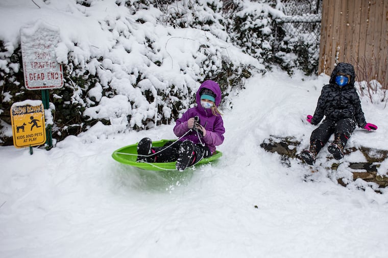
Hannah Bouwman, 7, sleds down a makeshift hill along with Desmond Sipman, 6, (right), behind their homes along Larchwood Ave, in West Philadelphia, Pa., on Tuesday, Feb. 2, 2021.Read moreTYGER WILLIAMS / STAFF PHOTOGRAPHER
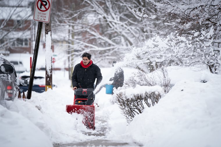
A man using a snow blower to clear out the sidewalk along Larchwood Avenue in West Philadelphia, Pa., on Tuesday, Feb. 2, 2021.Read moreTYGER WILLIAMS / STAFF PHOTOGRAPHER
Shamir Williams, 17, of West Philadelphia, (right), helps Kerry Dowd, of University City, (left), clear off snow on the car of Dowd’s moms car along Larchwood Ave, in West Philadelphia, Pa., on Tuesday, Feb. 2, 2021. Dowd is a Realestate investor and is planning to stop by his properties to shovel the snow.Read moreTYGER WILLIAMS / STAFF PHOTOGRAPHER
Mac Nickelz, 33, of West Philadelphia, shovels a fellow neighbors sidewalk along Larchwood Ave, in West Philadelphia, Pa., on Tuesday, Feb. 2, 2021. Nickelz lives along Larchwood Ave and has been shoveling homes since he was 13.Read moreTYGER WILLIAMS / STAFF PHOTOGRAPHER
The slightest slope in flat South Jersey draws a huge crowd of sledders to the small hill overlooking the Centennial football field in Haddonfield Feb. 2, 2021, the storm's third day .Read moreTOM GRALISH / Staff Photographer
Desmond Sipman, 6, makes a snow angel at the back of his home with fellow neighbors and his mom, Erin Rooney, in West Philadelphia, Pa., on Tuesday, Feb. 2, 2021.Read moreTYGER WILLIAMS / STAFF PHOTOGRAPHER
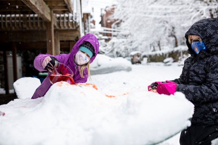
Hannah Bouwman, 7, (left), makes a snow volcano for a school assignment involving baking soda, vinegar, dish soap and food dye, while Desmond Sipman, 6, (right), watches in West Philadelphia, Pa., on Tuesday, Feb. 2, 2021.Read moreTYGER WILLIAMS / Staff Photographer
A pedestrian walks along Martin Luther King Jr. Drive as snow continues to fall in Philadelphia, Pa. on Tuesday, February 2, 2021. After fitful spurts of falling and blowing snow, wind gusts to near 50 mph, coastal flooding, and a marathon of sleet, forecasters promise the storm will exit sometime Tuesday.Read moreMONICA HERNDON / Staff Photographer
Micela and her husband Ernesto Ortiz dig out their sidewalk of some two or more feet of snow in Bethlehem, Tuesday, February 2, 2021.Read moreSTEVEN M. FALK / Staff Photographer
A city of Philadelphia snow plow navigates Brewery Hill Drive at Girard Avenue as snow continues to fall in Philadelphia, Pa. on Tuesday, February 2, 2021. After fitful spurts of falling and blowing snow, wind gusts to near 50 mph, coastal flooding, and a marathon of sleet, forecasters promise the storm will exit sometime Tuesday.Read moreMONICA HERNDON / Staff Photographer
Snow coats a tree on Girard Avenue in Philadelphia, Pa. on Tuesday, February 2, 2021. After fitful spurts of falling and blowing snow, wind gusts to near 50 mph, coastal flooding, and a marathon of sleet, forecasters promise the storm will exit sometime Tuesday.Read moreMONICA HERNDON / Staff Photographer
A pedestrian navigates the path along Kelly Drive as snow continues to fall in Philadelphia, Pa. on Tuesday, February 2, 2021. After fitful spurts of falling and blowing snow, wind gusts to near 50 mph, coastal flooding, and a marathon of sleet, forecasters promise the storm will exit sometime Tuesday.Read moreMONICA HERNDON / Staff Photographer
Snow coats a tree limb on Girard Avenue in Philadelphia, Pa. on Tuesday, February 2, 2021. After fitful spurts of falling and blowing snow, wind gusts to near 50 mph, coastal flooding, and a marathon of sleet, forecasters promise the storm will exit sometime Tuesday.Read moreMONICA HERNDON / Staff Photographer
Jim Holland clears snow at his home, in Norristown, PA, Tuesday February 2, 2021. A large snow storm began in the tri-state area on Sunday afternoon.Read moreJESSICA GRIFFIN / Staff Photographer
Maria Estrada, left and her younger sister Jacqueline Estrada, center, watch from inside the house while their mother Juana Rodriguez, right, tosses a snowball at her husband and son who are not shown in the photo but were shoveling the sidewalk, in Norristown, PA, Tuesday February 2, 2021. A large snow storm began in the tri-state area on Sunday afternoon.Read moreJESSICA GRIFFIN / Staff Photographer
Many families and friends in the area gather at Clark Park to sled down the hills in West Philadelphia, Pa., on Tuesday, Feb. 2, 2021.Read moreTYGER WILLIAMS / STAFF PHOTOGRAPHER
Ai Harada, of West Philadelphia, sleds down a hill in a unicorn floaty with the child she is babysitting for at Clark Park in West Philadelphia, Pa., on Tuesday, Feb. 2, 2021.Read moreTYGER WILLIAMS / STAFF PHOTOGRAPHER
Erica Blanch, of West Philadelphia, waves towards her husband, Jake Blanch and their son Charlie Blanch, 1, as they sled down the hill together at Clark Park in West Philadelphia, Pa., on Tuesday, Feb. 2, 2021.Read moreTYGER WILLIAMS / STAFF PHOTOGRAPHER
Paulina Obrebski (left) shakes snow from a tree branch as her daughters, Victoria (center) and Kaya (second from right) stand under it at Campbell Square in Philadelphia, Pa. on February 2, 2021.Read moreDAVID MAIALETTI / Staff Photographer
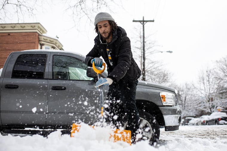
Andres Lopez clears the sidewalk, in Norristown, PA, Tuesday February 2, 2021. A large snow storm began in the tri-state area on Sunday afternoon.Read moreJESSICA GRIFFIN / Staff Photographer
Latinya Jones, and her daughter Lailah, build a snowman, in Norristown, PA, Tuesday February 2, 2021. A large snow storm began in the tri-state area on Sunday afternoon.Read moreJESSICA GRIFFIN / Staff Photographer
The Burlington County COVID-19 Vaccine Mega-Site at the Moorestown Mall remains closed Feb. 2, 2021. State offices and all six vaccine mega-sites were closed for a second day under a state of emergency in response to the winter storm.Read moreTOM GRALISH / Staff Photographer
A pedestrian walks near the Grumman Greenhouse sculpture partially during a snowy day on Cherry St &, N Carlisle St, Philadelphia, P.A.Tuesday, February 2, 2021.Read moreJOSE F. MORENO / Staff Photographer
Jim Holland clears snow from the sidewalk in front of his home, which is decorated for Valentine's Day, in Norristown, PA, Tuesday February 2, 2021. A large snow storm began in the tri-state area on Sunday afternoon.Read moreJESSICA GRIFFIN / Staff Photographer
Residents on Willington street in North Philadelphia clean off their cars on Tuesday, Feb. 02, 2021. The Philadelphia region has been enduring a marathon storm that began Sunday afternoon, with precipitation expected to last into the day Tuesday.Read moreHEATHER KHALIFA / Staff Photographer
Snow is cleared by the entrance to the Broad Street line at Temple University in Philadelphia on Tuesday, Feb. 02, 2021. The Philadelphia region has been enduring a marathon storm that began Sunday afternoon, with precipitation expected to last into the day Tuesday.Read moreHEATHER KHALIFA / Staff Photographer
A masked pedestrian walks past a shuttered business along Cecil B. Moore Ave. in North Philadelphia on Tuesday, Feb. 02, 2021. The Philadelphia region has been enduring a marathon storm that began Sunday afternoon, with precipitation expected to last into the day Tuesday.Read moreHEATHER KHALIFA / Staff Photographer
Pedestrians walk in the snow by 15th and Cecil B. Moore Ave. in North Philadelphia clean off their cars on Tuesday, Feb. 02, 2021. The Philadelphia region has been enduring a marathon storm that began Sunday afternoon, with precipitation expected to last into the day Tuesday.Read moreHEATHER KHALIFA / Staff Photographer
Cars can be seen piled underneath snow in North Philadelphia clean off their cars on Tuesday, Feb. 02, 2021. The Philadelphia region has been enduring a marathon storm that began Sunday afternoon, with precipitation expected to last into the day Tuesday.Read moreHEATHER KHALIFA / Staff Photographer
Brian Mermelstein, a sophomore, hits a tennis ball from the base of the bell tower as he plays a makeshift round of golf in the snow on the campus of Temple University in Philadelphia, Pa. on February 2, 2021.Read moreDAVID MAIALETTI / Staff Photographer
Rodney Roscher, 30, digs out his Ford Fusion under some 24-plus inches of snow in Emmaus, Tuesday, February 2, 2021.Read moreSTEVEN M. FALK / Staff Photographer
People dig out on Clewell Street in Bethlehem where more than two feet of snow fell during the storm Tuesday, February 2, 2021.Read moreSTEVEN M. FALK / Staff Photographer
Charlie Pellegrini goes off a ramp made out of snow on a hillside next to Strath Haven High School in Wallingford, Delaware C0unty, PA.Read moreCHARLES FOX / Staff Photographer
A pedestrian makes their way across Love Park in the evening on Feb. 2, 2021.Read moreCHARLES FOX / Staff Photographer
Computer models are suggesting the possibility of another storm affecting the region Sunday into Monday, perhaps with more snow. “There’s definitely a potential,” Trent Davis, a meteorologist with the National Weather Service Office in Mount Holly, said Tuesday. It was unclear Wednesday whether that would be a nuisance snowfall or something major.
By then, a considerable amount of the snow and ice should be gone. Temperatures the next two days will be above freezing during the day, and the February sun is gaining power by the day.
In the meantime, some folks could end up with very sore backs. Better than 30 inches was measured in far northern Bucks County near the Lehigh Valley. Snow totals typically ranged from eight to 10 inches in South Jersey, 10 to 15 north and west of the city, and up to 10 in the city.
Philly’s official 8.1 inches was the most since a January 2016 storm. The paltry 1.3 measured Tuesday and early Wednesday was more than quadruple what fell during the entire winter of 2019-20. “I was kind of wondering if I’d remember how to drive in it,” said Davis, who moved here from Ohio in 2018.
Tuesday marked the first time in 18 years that Philadelphia officially had experienced an inch or more of snow on three consecutive days, according to Tony Gigi, a meteorologist who helps run the phillywx.com chat board, and the storm’s impacts will lap into the melting period.
Catholic elementary schools in Philadelphia will open two hours late Wednesday, and parochial high schools will remain fully virtual for another day. Suburban Catholic schools will follow the decisions of their local school districts.
The three-day snow-and-ice siege, with wind gusts up to 50 mph and the worst of it coming during a workday rush hour, almost certainly would have been far more disruptive in normal times. But pandemic restrictions and other concerns have emptied offices, schools, and public-transit vehicles.
Profoundly heavy snows clocked parts of upstate Pennsylvania and North Jersey, and at least one death was reported in Allentown, and two people reportedly were shot to death in a snow-removal dispute in Luzerne County.
Trauma, however, was minimal around Philadelphia, by most accounts, and the region awoke to one of the more aesthetically magnificent snowfalls in recent memory, one that achieved a “wintry ambience ... appreciated by snow-lovers,” in the words of the weather service’s morning forecast discussion.
That the evergreens and the bare branches were tufted and layered thickly with snow spoke to one aspect of the region’s good fortune. For most utility customers, this was nearly a perfect storm. Peco experienced about 11,000 power outages total, well under 1% of its customers, said Myra Bergman, the utility’s vice president for communications, and it avoided major tree issues.
Why? The snow that began accumulating early Sundayafternoon got knocked off the trees by that 12 to 16 hours of sleet, which bounces off branches and wires, and by high winds. The sleet, which weighs about three times as much as snow, also helped anchor the tree bases in the frozen ground. By the time the heavy snow moved in Monday afternoon, the winds had backed off. The trees were able to hold their own as they held their snow.
SEPTA also held its own, canceling some Regional Rail runs Monday and detouring dozens of bus routes, but the Broad Street and Market-Frankford subways operated nearly normally.
The city lifted its state of emergency Tuesday, and announced it would resume trash and recycling collection Wednesday. Those who get pickups Mondays and Tuesdays were told to hold their trash until next week.
Temperatures possibly reaching the 40s on Friday should accelerate the melting. However, overnight freezes likely will create some dangerous black ice, and it’s possible that another winter storm could hit the region late in the weekend, which would be about the last thing the city’s $4.8 billion budget — already operating on razor-thin margins due to the coronavirus pandemic — needs.
Finance officials warned in a November report that it would have only $22.9 million in reserves by the end of the fiscal year. And while the city had no cleanup cost estimate yet, said spokesperson Mike Dunn, the report said that a “significant snowstorm” could devour that amount in a few days.
And meteorologists say it could take another hit next week. The European forecast model was bullish on a storm that would take a classic coastal track, more typical of the ones that produce major I-95 snows, although it appeared to be less enthusiastic about the potential on Wednesday. Such a storm is known as a “Miller-A,” named for the researcher who came up with the classification system in 1946.
The one that has been pestering the region since noon Sunday — and was still spinning 150 miles off New Jersey on Tuesday — traces its lineage to a feature that traveled across the country, lost its punch as it came eastward, then redeveloped on the Atlantic Coast as a nor’easter.
“Miller-As are notorious for being stronger than Miller-Bs,” said Brett Rossio, a meteorologist with AccuWeather Inc. “We are closely watching.”
He noted that the American computer model so far isn’t seeing much of a threat, compared with the European forecast.
“There’s still a lot of disagreement, like people having an argument,” said Reynolds Wolf, a Weather Channel meteorologist who was in Philadelphia covering this storm.
Said Rossio: “This is still a long way out. It’s still early.”
Inquirer staff writers Tom Fitzgerald and Kristen A. Graham and the Associated Press contributed to this article.
I am a staff writer and a weekend editor. I write about a variety of subjects, but most often about the neighborhood where we all live — the atmosphere.