Philly could have its biggest snowfall in two years by the time it stops Saturday
For the first time in two years, the National Weather Service issued a “winter storm warning” for snow, calling for 4 to 6 inches on Saturday, with inch-an-hour rates possible during early morning.
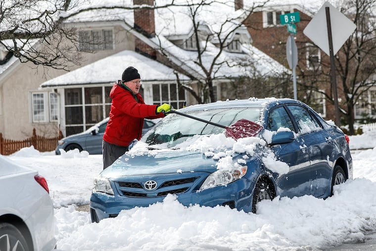
Unless scores of computer model runs have been out to sea, Philadelphia is in for its most snow-covered — and perhaps brightest — winter weekend in years.
With a certainty that bordered on rarity, government and private-sector meteorologists on Friday were in accord that several inches of snow could fall across the region, with an outside shot that some areas would be seeing 6 inches.
For the first time in two years, the National Weather Service issued a “winter storm warning” for snow, calling for 4 to 6 inches on Saturday, with inch-an-hour rates possible during the early-morning hours.
Granted, the bar isn’t particularly impressive, but “it’s at least possible” that when the final totals are in Saturday morning, Philly will have had its biggest accumulation since the beginning of a record 715-day snow drought, said Bob Larson, senior meteorologist with AccuWeather Inc. It hasn’t had a significant snow on a weekend since the winter before that.
» READ MORE: Philly went 716 days without an inch of snow falliing
In fact, the 0.6 inches of slop measured at Philadelphia International Airport on Tuesday was double what fell all of last winter. Meanwhile, up to 10 inches fell to the north and west.
In a winter on track to become one of the top 10 warmest in more than 150 years of record-keeping in Philadelphia, this would mark the second time in a month that snowfalls had occurred within a few days of each other. This, in a period in which temperatures have averaged a balmy 3.5 degrees above normal.
Saturday’s forecast high in the upper 30s would make it the first day this month in which the temperature failed to reach 40.
» READ MORE: For the Poconos, this could be a weekend, with more. snow due
About the snow
The snow, which was due to begin late Friday night or shortly after midnight, was forecast to end by midmorning. “It’s a quick-hitter,” said Michael Silva, a lead meteorologist at the National Weather Service Office in Mount Holly.
The sun is due to reappear, but AccuWeather’s Larson said the atmosphere will remain “unstable,” and snow showers, or even a squall, were on the table during the afternoon, especially north and west of Philly.
The weather service had Philadelphia in the bull’s-eye, with 5 inches forecast, which would top the biggest snow of the season, the 4.6 inches of Jan. 15-16.
» READ MORE: Philly's biggest snow of the year was in mid-January
The forecast amounts were a couple bumps up from the earlier projections. In its late-day discussion, the weather service cited computer models suggesting that the storm would be juicier. Conditions also were favorable for producing efficiently accumulating dendrites, those flake shapes so popular for holiday decorations.
Also, said Silva, temperatures were forecast to be below freezing during the snow, slightly colder than foreseen earlier, and since it would be falling at night, it would stick.
The moon isn’t much of a melter.
The storm, which was moving from the Tennessee Valley toward the Atlantic, was expected to pick up some moisture as it approached the coast, Larson said.
In addition, it would be getting a jolt from strong upper-level winds that would increase the snow rates, said Paul Dorian, meteorologist with the Arcfield forecasting service.
About the weekend
The storm shouldn’t be terribly disruptive since the bulk of it is likely to fall when most people don’t have to be anywhere.
PennDot planned a “full callout,” said spokesperson Brad Rudolph, and had brined all the major roads except Philly’s, which still had residual salt from the Monday storm.
Both Saturday and Sunday will be chilly but decent melting days, with temperatures expected to be mostly in the 30s.
A snow cover should survive the weekend, but the February sun will be going to town on it, and chances are that most of it will have assumed a different role in the water cycle by Monday morning.
On the bright side, with snow on the ground and the sun gaining wattage daily, the light should be quite dramatic during the days. Snow cover is the best reflector of the sun’s energy, and a study published in Nature in May noted that it can be several times brighter than the light beaming on bare ground.
If you’re venturing out, add sunglasses to the boot, hat, coat, and glove arsenal.
Phil redeemed?
The long-term forecasts, which were seeing a pattern change to wintry conditions that could last into March, now are saying that the groundhog may have been on to something when he saw his shadow on Feb. 2 and predicted an early spring.
» READ MORE: Earlier this month, Phil promised an early spring. Was he on to something?
Temperatures are expected to warm during the workweek and reach 50 degrees by Wednesday. Larson said cooldown is on tap for next weekend, followed by a subsequent warm-up “that looks impressive.”
The government’s Climate Prediction Center’s extended outlook to March 1 has the odds generally favoring above-normal temperatures in the eastern two-thirds of the nation.
It is unclear which models Punxsutawney Phil was consulting, but maybe he was on to something.
» READ MORE: So much has changed, but the magic and mystery of snow persist
