A winter storm warning for 4 to 6 inches of snow is in effect for early Saturday across the Philly region
Philly could see its biggest snowfall in two years.
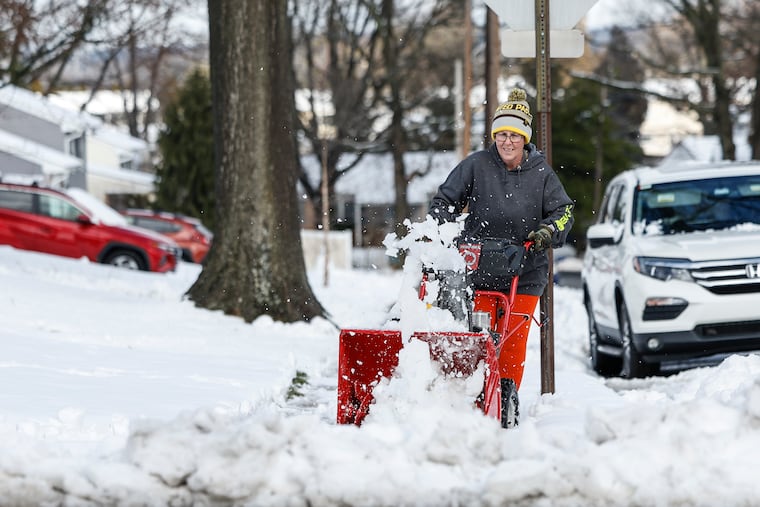
The region’s second snowfall of the week is all but a certainty Saturday, forecasters say, and this time significant accumulations are expected in South Jersey, Center City, and even at the often snow-resistant Philadelphia International Airport.
The National Weather Service has posted a winter storm warning for 4 to 6 inches of snow that includes those areas largely snubbed by Tuesday’s storm, offering somewhat of a consolation prize to the snow lovers in those places.
“It’s not out of the question” that Philadelphia experiences its biggest snowfall in two years, said Bob Larson, senior meteorologist with AccuWeather Inc., overtaking the 4.6 that fell on Jan. 15-16, which broke a 716-day snow drought.
The warning covers Philly, the neighboring counties on both sides of the Delaware River, northern Delaware, and the eastern halves of Montgomery and Bucks Counties.
Amounts to the north will be less, but it’s likely that at least a few more inches fall upon the Poconos.
» READ MORE: Recent snow could mean a big weekend for Poconos skiing, finally
Snow — and this time around it will be just about all snow, except for maybe some mixing at the Shore — is due to start either very late Friday night or just after midnight Saturday and be over by mid-morning. Larson said that given how fast the storm will be moving, it’s all but out of the question that this snowfall would rival some of the 10-inch totals well north and west of the city on Tuesday.
But it’s possible that some areas between Philadelphia and Washington, D.C. could get as much as 6 inches, agreed Paul Dorian, meteorologist with the Arcfield forecasting service.
Given the timing, it shouldn’t be terribly disruptive, but in a winter like this one — actually the last two — 4 to 6 inches would qualify as an event around here. And not just around here.
Tracking with the warming planet, winters have been trending warmer, and this season the El Niño event in the tropical Pacific has flooded much of North America with robustly mild, Pacific air, meteorologists say.
» READ MORE: As expected, El Niño has been a dominant force this winter
Sea-surface temperatures over a vast portion of the Pacific have consistently been about 3 degrees above normal, heating the overlying air, and generating strong upper-level west-to-east winds that have energized a storm track across the southern United States.
Many areas to the north have been astonishingly snow-deprived. Take Minneapolis. The city received 6.9 inches of snow Wednesday, a record for the date, but more notable was that it was the first time an inch of snow had fallen since Halloween, said Tyler Hasenstein, a meteorologist in the local forecast office. The 14-inch total for the season is about 40% of normal.
A whole lot of the natives didn’t mind the attendant inconveniences that came with the end of the snow drought. The consensus reaction, he said, was: “It’s about time.
“A lot of people do enjoy the winter for the snow, which is part of the reason they live here.”
New York’s seasonal total stands at 5.5 inches, Boston’s, 9.3. If Saturday’s forecast holds, Philly, which is at 8.3 inches so far, would become the snowiest among the four largest cities in the I-95 corridor.
The coming storm
The potential snow-maker isn’t all that impressive, said Joe DeSilva, meteorologist in the weather service’s Mount Holly office.
Rather than a potent coastal storm, this one will be a so-called Alberta clipper, so named because they often originate in western Canada and speed across the United States. Another variant is the “Saskatchewan screamer.”
In most cases these things pass by to the north and shake out a few flakes or rain showers over Philly.
This one is scooting to the south, and Philly will be on the colder side. In addition, said Dorian, who is based in Valley Forge, the snow rates will be getting a lift from strong winds in the upper atmosphere.
In terms of impacts, PennDot couldn’t ask for better timing. Not only is it coming on a Saturday, most of us are likely to sleep through most of it, and it will be over by midmorning.
And whatever lands should be rather easy to shovel, since it won’t be nearly as waterlogged as what descended upon the city on Tuesday.
About Tuesday’s snow, or was that white rain?
While the outer suburbs were creamed with snow Tuesday, only 0.6 inches was measured at Philadelphia International Airport. Most of what fell in Center City, South Philly, and at the airport was white rain as temperatures remained just above freezing.
After the rain changed to snow around 7 a.m. at the airport, the estimated precipitation total was 0.2 inches.
» READ MORE: On Tuesday, in some parts of Phllly it was the case of the missing snow
Based on the standard snow-to-liquid ratios, on average that 0.2 would have resulted in 2 to 3 inches of actual accumulated snow — similar to what is forecast for Saturday, when a similar amount of precipitation is forecast to fall.
About Saturday
It won’t be especially frigid during the snow, Larson said, but this time it will be at freezing or just below throughout the region.
Plus the upper air will be cold, and as a rule, the colder the atmosphere, the higher the snow-to-liquid ratio.
The weather service says some isolated areas could wind up with 4 inches.
Once the snow stops, temperatures are forecast to stay in the 30s, which would mark the first time this month that they failed to reach 40 in the city.
Is snow a lock?
Not until you see the whites of the flakes.
Computer models should never be confused with actual weather. They have been known to hallucinate, even in Minnesota, Hasenstein said.
» READ MORE: Have you noticed that computer models do tend to change their minds?
All winter, he said, the models have been seeing snowstorms six and seven days in advance, “and by the time we reach day three or four, it’s too far south to affect us.”
Sound familiar?
