Philly’s surprisingly cold and snowy winter isn’t over yet, but big changes are coming
The atmosphere had a good a laugh on the seasonal forecasters
Robert Koopmeiners is up to here with this winter and is among the masses more than ready for the atmosphere to flip the switch.
“It’s getting kind of old,” he said. But he wasn’t complaining about Arctic freezes, or winter storms, or black ice, or hideously darkening mountains of plowed snow.
He was talking about the weather in Colorado, where he is a National Weather Service meteorologist, where bone-dry Denver has set nine high-temperature records since Dec. 1, where wildfire alerts were in effect, and water is getting scarce.
Warm West, cold East, and vice versa are standard fares in the great national atmospheric seesaw that hasn’t been doing much seesawing lately, as if a boulder has been placed atop our end of it.
That’s the result of an atmospheric roadblock for the ages in the high latitudes around Greenland, meteorologists say, that has allowed winter to reappear with a ferocity not experienced in several years in the Northeast, and a winterlong spring in parts of the West. The cold in the East may even be related to rising global temperatures.
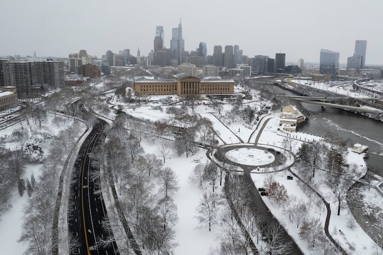
The result for the Philadelphia region has been one of the colder and snowier meteorological winters — the Dec. 1 to Feb. 28 period — on record. Officially Philadelphia has had more days of snow cover of an inch or more than in the five seasons ending with the winter of 2023-24 combined.
After quite a wintry start to the new week, with even some more snow possible, a major warmup is due to begin with a spring teaser possible next weekend. (It may turn colder the second half of the month, but that can wait.)
In the meantime, the atmosphere is enjoying a belly laugh over the preseason outlooks for the winter of 2025-26.
Philadelphia’s winter scorecard
By convention, the weather community divides the seasons into three-month increments. In part that’s in recognition of the fact that weather often has an adversarial relationship with astronomy. For example, it has snowed, and hit 90 degrees, in the astronomical spring, the period between the vernal equinox and summer solstice.
For the three-month 2025-26 winter period, official temperatures at Philadelphia International Airport have averaged a shade over 33 degrees, putting it in the top third for coldest winters in the period of record dating to the late 19th century.
The official snow total is in the top 20% of all winters on record. The normal through February is just under 20 inches.
What forecasters predicted would happen
Zero. That would be the number of publicly available winter outlooks that predicted Philly would experience 30.1 inches of snow, 150% of normal.
AccuWeather Inc. and 6abc went with 14 to 18 inches. Fox29 called for 16 inches, and 17 days of snow cover. At last count, that snow-cover count was up to at least 35. Other forecast services called for normal — 23.1 inches — or slightly above-normal snowfall.
Regarding temperatures, all the outlooks foresaw normal — the three-month average is 36.1 degrees — to above-normal temperatures for the Philly region, save for Arcfield Weather, a private-sector company, which went for below.
‘Blocking’ has been the leitmotif of Philly’s winter
If it seemed that what happened kept happening, that was more than perception.
It was the result of particularly vigorous “blocking” in the vicinity of Greenland in which high pressure, or heavier air, persists in the upper atmosphere. It was a massive obstruction that kept directing cold air and storms toward the East while toasting the West, said Climate Prediction Center branch chief Jon Gottschalck.
The East got stuck under a “trough” of upper-air low pressure that favored storminess and cold, he added. The West, quite the opposite.
“The blocking pulled the storms eastward, and the cold followed,” said Paul Pastelok, Accuweather’s longtime seasonal forecaster. “We should have caught on to that.”
In addition, an upper-air pressure pattern over the Arctic — the Arctic Oscillation — was stuck in its negative phase from December until recently, said climate center meteorologist Laura Ciasto, with negative consequences for local winter-phobes.
When it’s negative, the weather-moving west-to-east jet stream winds can become more active at the midlatitudes where we live, and the conditions colder and stormier. The oscillation has had “an interesting winter,” she said. “Typically,” she said, “we expect the AO to fluctuate.”
Related to the oscillation’s behavior were episodes of “polar vortex stretching,“ said Ciasto. The vortex’s powerful winds usually trap cold air in the Arctic, but on occasion they weaken and ”stretch,“ allowing cold air to spill southward.
Another explanation for why the forecasts went awry may be an obvious one: We’re not used to this level of Arctic cold or prodigious snowfalls like the Sunday-Monday event that creamed parts of the region with 20 inches or more. “We have simply gone many years without experiencing a storm like this,” said Owen Shieh, warning coordination meteorologist at NOAA’s Weather Prediction Center.
Did the world suddenly grow colder?
No, the planet didn’t cool off precipitously. In fact, said Pastelok, the blocking may have been related to warming-related sea-ice reductions near Greenland. The solar energy absorbed by freshly freed waters could have effects on pressure patterns in the high atmosphere, he said, adding that for now, that’s only a hypothesis.
While the world evidently cooled slightly last year after a record 2024, according to NOAA’s database, it’s still about 2 degrees Fahrenheit warmer than the 20th-century average, the supply of Arctic air isn’t quite as it used to be.
As it turns out, Philly’s winters in the 21st century have trended milder, with average temperatures about 2 degrees Fahrenheit above long-term averages.
The overall warming trend has been one reason the climate center has had the odds favoring above-normal winter temperatures for Philly for the last seven consecutive winters. And they indeed were above normal for six straight years — but not seven.
Retired climate center forecaster Mike Halpert once remarked that while sticking with the trend can be a smart bet, “some years you’re going to be woefully wrong.”
