Philly snow updates: Rare blizzard warning continues as snow falls across the city; latest forecast and timing
Rain has shifted to snow as part of a winter storm expected to drop more than a foot of snow across the Philly region.
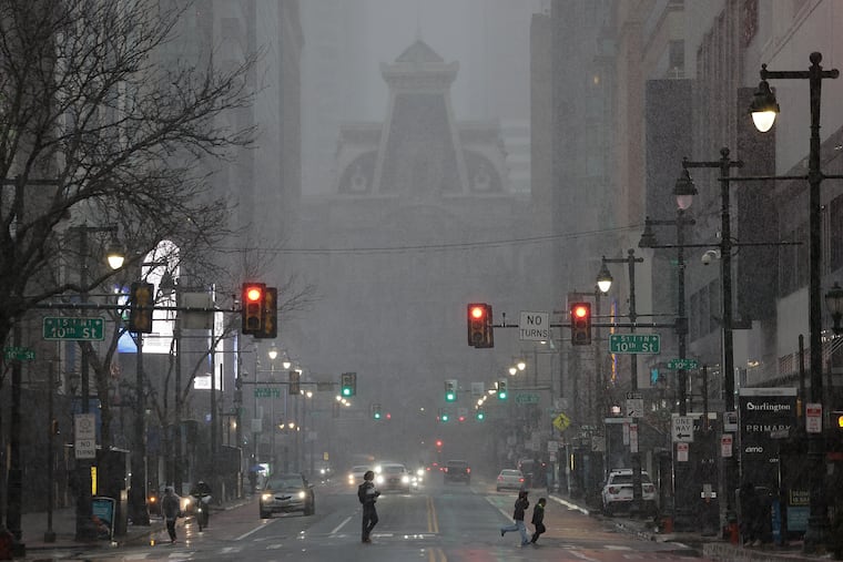
A rare blizzard warning remains in effect as a massive winter storm is expected to drop more than a foot of snow in and around Philadelphia through Monday.
Snow began falling in Philly early Sunday evening and is expected to continue through Monday afternoon, with the heaviest snowfall overnight into the morning. Here's the latest map.
A citywide snow emergency is in effect in Philadelphia, while both New Jersey and Delaware have declared a state of emergency.
City schools will go virtual Monday, while trash and recycling collection in Philadelphia will be suspended until Wednesday.
Bands of heavy snow moving across the Philly region
Some “bands” of heavy snow were moving across the region Sunday evening, and that is likely to continue through the night, said Nick Guzzo, meteorologist with the National Weather Service in Mount Holly.
“Banding,” in which narrow corridors of heavy snow migrate from place to place, are common during winter storms. Areas under the bands can receive a quick couple of inches of snow.
By nightfall some totals of 1 to 2 inches were reported in the Philadelphia area and at the Shore. Forecasters said rates of two inches an hour were possible at times.
Tractor trailer accident on Atlantic City Expressway
Heavy bands of snowfall and strong wind gusts are creating blizzard-like conditions across the region, making it dangerous and difficult for drivers.
NBC10 reporter Ted Greenberg came across a tractor trailer involved in an accident just east of exit two on the Atlantic City Expressway.
It wasn't immediately clear if there were any injuries.
DoorDash suspends service in Philadelphia
DoorDash, the food delivery service, has suspended operations in Philadelphia and New Jersey amid the snow storm.
According to a company press release, DoorDash deliveries have ended as of 9 p.m. on Sunday and will not begin again until at least 12 p.m. Monday, depending on conditions at that time.
"We’re suspending operations across impacted areas to keep our community safe," said company spokesperson, Julian Crowley, in a press release. "This is a serious storm — we’ll resume when it passes."
Amtrak suspends Keystone Service
Amtrak announced it is suspending its Keystone Service, which operates between Harrisburg and Philadelphia, until at least noon Monday.
At least 12 trains have been canceled as of Sunday night.
Amtrak said Pennsylvanian trains, which travel between New York City and Pittsburgh, are expected to operate on a normal schedule Monday.
At least 15,000 without power across Southern and Central New Jersey
At least 15,000 people were without power in Southern and Central New Jersey on Sunday evening around 8 p.m., according to outage maps from energy providers Jersey Central Power & Light and Atlantic City Electric.
In the Philadelphia area, as snow blanketed the region, roughly 1,500 Peco customers were affected by outages around 7:50 p.m., the company’s outage map indicated. Residents can monitor the company’s outage map to see where an outage has happened and the estimated restoration time.
Residents can receive outage alerts from Peco by texting "ADD OUTAGE" to 697326. To report an outage, text “OUT” to the same number or call 1-800-841-4141 or use the company’s online portal. For downed power lines, call the same number.
SEPTA to suspend all bus routes
On Sunday evening SEPTA issued updated guidance on available service for the rest of the day.
All SEPTA bus routes will be suspended at 10 p.m. Sunday, the transit agency announced.
Regional Rail trains and the Norristown High Speed Line will operate until the end of scheduled service on Sunday evening.
NJ Transit to suspend rail service
NJ Transit will suspend its all rail service by 9 p.m. Sunday, the agency announced in a news release.
Earlier, the transportation agency stopped its bus, light rail, and Access Link services. Trains were initially excluded from the closures, but Gov. Mikie Sherrill warned the shutdown was likely.
Some routes will end service before 9 p.m., but no trains will leave their origin point after 9 p.m. Customers should check the transit authority’s website or social media for updates.
A slew of travel restrictions put in place across the Philly region
PennDOT reduced the speed limit on a number of Philadelphia-area highways Sunday evening, including I-95 and the Schuylkill Expressway.
The speed limit is now 45 mph on the following Philly-area roadways:
Interstates 76, 95, 295, 476, 676
U.S. Routes 1, 30, 202, 422
State Routes 63, 100 Spur and 309
PennDOT also issued Tier 4 restrictions on major roadways in Eastern Pennsylvania, which prohibits all commercial vehicles from driving. It also restricts buses, motorcycles, RVs, and passenger vehicles towing trailers.
Philly City Council closed Monday
All Philadelphia City Council offices will be closed Monday as a massive winter storm makes its way across the region, President Kenayatta Johnson's office announced Sunday afternoon.
A Public Health and Human Services Committee hearing on reproductive health scheduled to take place Monday will be postponed to a later day, .
Philadelphia Mayor Cherelle L. Parker had previously announced all city offices and schools would be closed Monday due to the storm.
Hundreds of flights canceled at Philadelphia International Airport
356 flights had been cancelled at Philadelphia International Airport on Sunday as of 5 p.m., as snow started to blanket the city. Another 579 flights were cancelled for Monday, according to FlightAware, which tracks flights.
“Passengers should check on the status of their flights with their airlines—the airlines will also provide guidance on what passengers should do in the event their flights are cancelled,” said airport spokesperson, Heather Redfern on Sunday afternoon via email.
Some 40 million square feet need to be cleared at the airport when snow falls, including on airplane runways and taxiways. The airport also has an additional 11.9 million square feet of space on roadways, ramps and parking lots.
Photos: Snow begins to fall in Philadelphia
PSE&G prepares for outages due to 'heavy wet snow and elevated winds'
Outages due to the snowstorm are expected, Brian J. Clark, senior vice president of PSE&G, the energy company based in Newark, said in a press conference around 3:45pm on Sunday.
PSE&G, which provides electricity and gas, services parts of Burlington, Camden, and Gloucester Counties.
“The increased heavy wet snow and elevated winds remain our major concerns,” said Clark on Sunday. “We may see large limbs and possible decayed trees fall and make contact with our lines.”
'Code Blue' for Philadelphia, city to open warming sites
City officials on Sunday instituted a "Code Blue" that's set to last until 9 a.m. Tuesday.
A Code Blue is declared when precipitation is falling and temperatures are 32 degrees or lower, or when temperatures feel close to or below 20 degrees due to the wind chill. The designation means that the city sends out outreach teams 24 hours a day to find people without shelter and take them to "safe indoor spaces."
It also opens up additional shelter beds, and residents in emergency housing are allowed to stay inside all day. (Some shelters require residents to leave in the morning and return at night.)
Rain switches over to snow in Philly; nearly 2 inches already in Somers Point
Rain began switching over to snow in Center City Philadelphia and across the region just before 4 p.m. Sunday as residents brace for snowfall totals of a foot or more.
In Somers Point, N.J., 1.7 inches of snow had already fallen, as reported to the National Weather Service by a trained spotter. Another recorded 2 inches of snow in Belltown, Sussex County, Del.
The agency is still calling for 14 to 20 inches of snow to fall in and around Philly through Monday morning, with the heaviest snowfall expect to take place this evening.
Camden, other school districts announce snow closures
As the blizzard bears down, school districts across the region have announced either pivots to virtual instruction or full closures.
Cherry Hill, Moorestown, and Evesham are closed, for instance; so are Lower Merion, Neshaminy and Downingtown. Pennsbury and Central Bucks have called virtual instruction days, while Upper Darby will move to a remote learning day.
Camden schools will be closed. The district has amended the school calendar, tacking on an extra day to the end of the school year. Elementary students will now finish the school year on June 24, and high school students on June 25.
Philly residents 'snowload' ahead of Sunday's storm
The precipitation had yet to shift from rain to snow Sunday afternoon, but patrons at neighborhood bars were already buttoning up their beer coats.
It’s a phenomenon called a “snowload” — when people flock to barstools and find solace from bad weather at the bottom of a citywide special or hot toddy, according to Les & Doreen's Happy Tap bartender Bill Coburn and others.
With the city shut down and some workplaces closed for inclement weather Monday, blizzards and beer just make for the perfect adult snow day, bargoers said.
Slightly less snow in latest Philly forecast as heavy snow falls in Delaware
At midafternoon the nor’easter was intensifying off the coast of Virginia, and heavy snow had moved as far north as southern Delaware.
Rain continued in the Philly region, and snow was likely to hold off until 5 or 6 p.m., said Tom Kines, senior meteorologist with AccuWeather Inc.
AccuWeather’s forecast amount, 10 to 14 inches, was more conservative than the National Weather Service’s call for 14 to 20 inches. The weather service had shaved off a few inches from its earlier forecast as updated computer guidance was less bullish on the amounts.
PATCO to operate on snow schedule Sunday and Monday
PATCO trains will run at reduced speeds on Sunday and on an abbreviated schedule on Monday as the region braces for a significant winter storm.
On Sunday, trains will operate on a typical Sunday schedule but trips may take up to 10 minutes longer in order to maintain the safety of passengers and crew, the agency said.
On Monday, trains will operate every 12 minutes for most of the day, as opposed to the typical 5-7 minutes at peak times and every 15-30 minutes at other times.
NJ Transit to suspend most service ahead of storm
NJ Transit will suspend its bus, light rail, and Access Link service at 6 p.m. Sunday, the agency announced.
Trains will continue to run, but both the agency and Gov. Mikie Sherrill warned a shutdown later this evening was likely.
Speed restrictions of 35 miles per hour will go into effect on the New Jersey Turnpike, Garden State Parkway, and other highways through the state at 3 p.m.
'These kind of winters were common when I was a kid'
Holding a single grocery bag, Eric Dobson, 57, was taking the impending storm with calm and nostalgia.
“These kind of winters were common when I was a kid,” said the Germantown resident. “I guess we have become soft, so we panic.”
With enough salt still stocked up at his home from last month's storm, Dobson's mind was on getting some groceries at the Germantown Weavers Way Co-op.
SEPTA expects ‘significant service disruptions’
As the region awaits the arrival of a snowfall that is expected to be in the double digits, SEPTA is warning riders that transit will be impacted.
“We want to be clear with our customers – there are going to be significant service disruptions,” said SEPTA General Manager Scott A. Sauer in a statement. “This is going to include delays, trip cancellations, and likely shutdowns of routes and entire modes of travel.”
Whenever possible, SEPTA will provide customers with at least two hours' notice before service suspensions, the agency said.
Pennsylvania issues disaster declaration; commercial driving restrictions begin at 3 p.m.
Gov. Josh Shapiro announced a disaster emergency during a new conference Sunday afternoon ahead of a massive snowstorm expected to blanket most of Eastern Pennsylvania, including Philadelphia.
The declaration allows state resources to be activated and enables local governments to activate their own emergency plans to respond to the storm, which is expected to drop a foot or more of snow in and around Philadelphia.
Shapiro said state officials expect the heaviest snow — potentially one to two inches an hour — to begin around 5 p.m., and urged drivers to travel only if absolutely necessary.
Despite rain, more than a foot of snow still expected to fall in Philly
Rain continued to fall Sunday afternoon with temperatures well above freezing, but forecasters say a drastic change for the worse is coming.
Blizzard warnings are in effect for the Philly region and all of New Jersey and Delaware for wind gusts to 45 mph and 14 to 20 inches of snow.
Those estimates may be “a bit high,” said Ray Martin, lead meteorologist with the National Weather Service Office in Mount Holly, but a “bit high” still would be quite a boatload of snow, the most since February 2010.
What is a 'bomb cyclone?'
The storm developing off the Southeast Coast will qualify as a meteorological “bomb cyclone,” said Cody Snell, meteorologist with the Weather Prediction Center.
Just what does that mean? The technical description is on the geeky side — a barometric pressure drop of 0.7 inches in the center of a cyclone in a 24-hour period. Unofficially, it’s one mighty intense storm.
It so happens that the U.S. East Coast is in a prime area to experience the effects of those storms, according to the atmospheric scientists who are credited with minting the term in a 1980 paper, John Gyakum and Frederick Sanders.
Trash collection in Philly suspended through Wednesday
Trash and recycling collection in Philadelphia will be suspended the next few days as the city braces for as much as two feet of snow.
Collections are suspended Monday and Tuesday, the city announced. As of now, service will resume Wednesday on a two-day delay, with Monday collections picked up Wednesday and subsequent days following the same schedule.
The city is also suspending collections in rear driveways for the entire week, due to the possibility of trucks getting stuck in the snow. Residents are asked to set their materials in front of their homes for pickup.
Philly schools go virtual Monday
With an eye toward the coming blizzard, the Philadelphia School District has already called a virtual instruction day for Monday.
All district offices will also operate virtually.
“While we work to the greatest extent possible to keep schools open for in-person learning to accelerate student achievement, we also consider the staff members who are commuting from across the region and keep the safety of students and staff as our top priority,” Superintendent Tony B. Watlington Sr. said in a message to families and staff.
Snowfall totals increase in latest forecasts; blizzard warnings expand
The National Weather Service expanded its blizzard warnings to include Philadelphia Sunday morning, as a "potentially historic winter storm" makes its way towards the Northeast.
Philadelphia, Bucks, Delaware, and eastern Montgomery Counties, and all of New Jersey and Delaware, are now under blizzard warnings through Monday.
Predicted snowfall has also increased in the past few hours, with as much as two feet of snow possible in the city. Winds gusts up to 60 mph and snowfall rates exceeding one to two inches per hour are also expected, forecasters said.
Philly snow emergency goes into effect Sunday afternoon; city government closed Monday as schools go virtual
“Mother Nature has spoken again and made it clear that winter is not over,” said Mayor Cherelle L. Parker during an emergency press conference, declaring a citywide snow emergency, starting 4 p.m Sunday. “Yet another big winter storm is coming. It’s a major snow storm with real accumulation anticipated, and it’s heading our way.”
City government and courts will not open Monday, while public schools will switch to virtual learning. SEPTA riders should expect significant service disruptions over the next three days, said officials, who implored drivers to stay off the road Sunday.
Dominick Morales, the city’s emergency management coordinator, described the expected storm as “dangerous,” adding that heavy, wet snow could threaten trees and power lines.
‘Blizzard?’ It’s been awhile for Philly
Officially Philadelphia has not recorded a blizzard since March 1993.
To meet the criteria – three consecutive hours of winds of 35 mph or greater and/or heavy snow reducing visibility to a quarter mile for three straight hours – the conditions would have to be observed at the first-order measuring station, which is at Philadelphia International Airport.
The criteria weren’t met during the record 30.7-inch snowfall of Jan. 7-8, 1996, but at the time many meteorologists at the National Weather Service in Mount Holly argued that in the court of common sense it was indeed a blizzard.
Snow, after it hits 52 degrees? It’s happened before
On Saturday it reached 52 degrees in Philly as more snow vanished (not the mountains), and here we are a day later with a major snowstorm expected.
A warmup preceding a snowfall isn’t all that unusual this time of year, when the battles between the encroaching warm seasons and the retreating winter can be intense. Storms tend to form along thermal boundaries, and this is a prime for those contrasts. In today’s case an invasion of cold air is interacting with warmer air over the Atlantic Ocean.
Once powerful storms get going they can draw in cold air. Plus the upper air this time of year can be quite cold, and heavily falling snow can bring some of that to the surface.