Snow ends with 5.5 inches north and west of Philly, temps could reach 50 Wednesday
After a sequence of storms, the same areas that experienced twice as much snow as the city should experience twice the melt over the next several days.
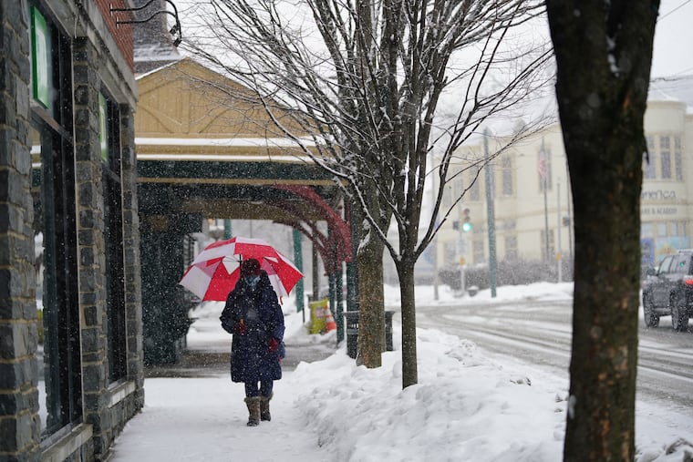
The heaviest of the rapidly falling snows on Monday — up to 5.5 inches north and west of the city — landed upon some of the areas that have been favorite targets of those cotton-ball flakes for the last three weeks. And that, in all likelihood, is deeper than coincidence.
The impacts of elevated terrain and distance from the core of Philadelphia’s “heat island effect” are well-known. But what occurred Monday also could have been a case of snow begetting snow, said Chad Shafer, a lead meteorologist with the National Weather Service Office in Mount Holly.
He said that some studies have suggested that a dense snowpack, which would have a chilling effect on the overlying air, could have an enhancing effect on snowfall. “It certainly can’t be ruled out,” he said.
Totals on Monday ranged from 0.8 inches at Philadelphia International Airport to 5.5 inches in Bucks and Montgomery Counties. Since Jan. 31, Philadelphia officially has measured 17.3 inches, but twice that much has fallen outside the city.
And after that rather remarkable sequence of storms, those same areas outside the city should experience twice the melt over the next several days. Temperatures are due to reach at least the 40s every day this week, and perhaps 50 on Wednesday and Saturday.
» READ MORE: After three weeks of snow, a winter break is likely
In addition, the government’s Climate Prediction Center sees the odds favoring above normal temperatures in the eastern two-thirds of the nation in its outlook covering the first week of March.
Monday — what Joe Miketta, the weather service’s warning coordination meteorologist in Mount Holly, called “another fun day in paradise” — may be the caboose of the storm train.
As it had on Thursday, the snows came in a hurry, leading to some road closures, including portions of Route 352 and 401 of Chester County that were blocked off for several hours.
Most highways were just wet, said PennDot spokesperson Chelsea Lacey-Mabe, but the ramps have been problematic. Southbound lanes of Route 1 were closed because of an overturned tractor-trailer at the 272 interchange in western Chester County.
Snow moved into areas west of the city at midmorning and spread eastward. Despite borderline freezing temperatures and the growing power of the February sun, it fell heavily enough to accumulate significantly in Bucks, Chester, and Montgomery Counties.
It was set off by a fast-moving moving front and got a lift from 70 mph winds in the upper atmosphere. The system “somewhat over-performed,” the weather service said, and stirred up powerful gusts at the Shore.
But snow generally was under an inch in South Jersey, and shunned the Shore entirely. The Atlantic City airport has measured just 7.3 inches for the season. Philadelphia is at 23.9 officially; the normal for an entire season is 22.4. .
And some areas north and west of Philadelphia are pushing three and four feet for the season.
Elevations certainly are a factor, said Shafer. From Center City the terrain slopes upward along the “fall line,” and reaches as high as 450 feet in the city itself. Temperatures decrease with height, and the elevation can give the updrafts that cause rain and snow and extra life.
» READ MORE: So much has changed, but the magic and mystery of snow endure | Book excerpt
“There’s a reason we look at the fall line a lot,” he said. What’s more, storms form along the boundaries of warm and cold air, and snow cover can affect where those boundaries set up. “The fact that those influences exist certainly implies that smaller-scale effects would exist.”
That, he said, might argue for the possible impacts of a dense snow cover on snowfall.
And if the forecast holds, that’s about to become less of a factor by the day.