Expect up to 6 inches of snow in Philly, forecasters say, then a weekend freeze
Light snow will yield to heavier snow mid- to late morning, the weather service says, impacting both rush hours.
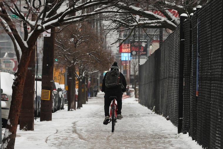
The Philadelphia phase of what has been one of the harsher Arctic outbreaks on record across the nation is about to reach its climax, with what forecasters say will be a significant snowfall Friday, affecting both the morning and afternoon commutes, followed by a deep freeze.
The snow is forecast to begin before daybreak and continue well into the night, with up to 6 inches possible, said Sarah Johnson, the warning coordination meteorologist with the National Weather Service in Mount Holly.
A good 12 hours before the first flakes were expected to flutter upon Philly, the impending storm already was having an impact, with Philadelphia and numerous other school districts announcing that kids would be getting a three-day weekend, and others at least a three-day furlough from riding the buses. The Archdiocese of Philadelphia announced that classes would be virtual.
The city declared that a state of emergency would go into effect at 7 a.m. SEPTA advised that it will be operating at a normal schedule in the morning but that riders should expect delays later.
While only light snow was expected in the early going, Johnson said, “Even if there’s not too much on the ground, given how cold the ground is already, when it starts falling, we could see slippery conditions.”
She added that with snow, less can be worse: “Sometimes if there’s less, people underestimate the kind of caution they should take.”
» READ MORE: After 716 days, the snow drought had to end sometime
And it’s not as though folks have had a lot of practice. This may be the second snow of the week, but it’s also only the second in the last two years. The one earlier this week ended a record 716-day period in which Philadelphia did not experience an inch of snow.
When will the snow become heavier?
The best estimate is that snow rates will pick up around 10 or 11 a.m. and continue until about 4 p.m., said Alex Staarmann, a Mount Holly meteorologist.
Colleague Johnson said the snow almost certainly should shut off completely before midnight.
It then will get cemented into place as temperatures tumble into the teens. On Saturday, the snow will be blowing, rather than falling, as winds gusting to 35 mph and temperature readings in the 20s drive wind chills into the single digits.
Where will accumulations be the highest?
A likely area for the highest accumulations, maybe more than 6 inches, would be central New Jersey, the weather service says.
Philadelphia, in any event, should be “more in the upper end” of the forecast ranges, said Johnson. A winter storm warning covers the city; all its adjacent counties, save for outer parts of Montgomery and Bucks Counties, which are under an “advisory;” and northern Delaware.
» READ MORE: Snowflakes are amazingly complex. We can thank an unschooled farmer for teaching us
However, pinpointing the jackpot and snow-deprived areas is a messy business involving everything from microclimate issues, to microphysics, to flake sizes, to the day-to-day chaos of the three-dimensional atmosphere.
The forecast amounts are likely to shift, at least subtly, through the day since the meteorological setup will be complex, forecasters said, with a developing coastal storm interacting with an unusual upper-air system.
Meteorologists agree that two of the big factors would be “banding,” in which bursts of heavy snow target an area while snubbing other places nearby, and “ratios,” or how much snow will pop out of the precipitation that falls.
Snow and water
On average, an inch of rain yields about a foot of snow around here — a snow-liquid ratio of 12:1 — but the ratios are likely to be low early, said Johnson, then pick up later.
She said that conditions at times may become ripe for “dendrites” — those six-sided crystals so often depicted in holiday decorations — which accumulate efficiently.
» READ MORE: So much has changed, but the magic and mystery of snow endure
It is possible, the weather service said in its afternoon discussion, that at times the ratios could go as high as 20:1, in which 0.1 inches of precipitation would produce 2 inches of snow.
Overall, the consensus forecast range from the weather service and commercial companies was from 3 to 6 inches throughout the region. But it remained unclear who would be getting the 3, and who the 6.
One thing is certain. It’s not the winter of 2022-23, when all of 0.3 inches fell officially at Philadelphia International Airport. As of Thursday, this season’s total stood at 3.4 inches.
Why all the snow all of a sudden?
For the last week, bitter cold has been like a national reality show. Football fans watched the Chiefs beat the Miami Dolphins in Kansas City with below-zero temperatures, and an extraordinary decision to postpone a game in Buffalo when blizzard conditions were expected along with 65-mph winds.
» READ MORE: Warmups over the Arctic can chill the United States
A disturbance in the upper atmosphere over the Arctic, known as a “sudden stratospheric warming,” may have played some role, NOAA research scientists Amy Butler and Laura Ciasto wrote in a blog post on Wednesday.
A stratospheric warming can weaken the “polar vortex” winds that circle the Arctic at 100 mph in winter and quarantine the cold up that way, allowing frigid air to spill southward, sometimes into the United States.
“I wouldn’t discount any stratospheric impacts,” Ciasto said Thursday. But she said this warming “will be very brief” and, besides, other players would be affecting weather across the country, including the ongoing strong El Niño warming in the tropical Pacific.
» READ MORE: El Niño will continue to be a major player this winter, forecasters say
El Niño impacts are forecast to last through the winter as the ocean heats the overlying air and juices storm tracks across the United States.
Warm Groundhog Day?
In the short term, a major warmup is due to start Tuesday, and the government Climate Prediction Center’s eight-to-14-day outlook has temperatures above normal across the country through Feb. 1.
As for the rest of February, the climate center says winter can go either way.
