Nor’easter is likely to cause significant flooding at the Shore, and winds may gust to 60 mph
The intensifying storm has the potential to become a "bomb cyclone," a meteorologist says.
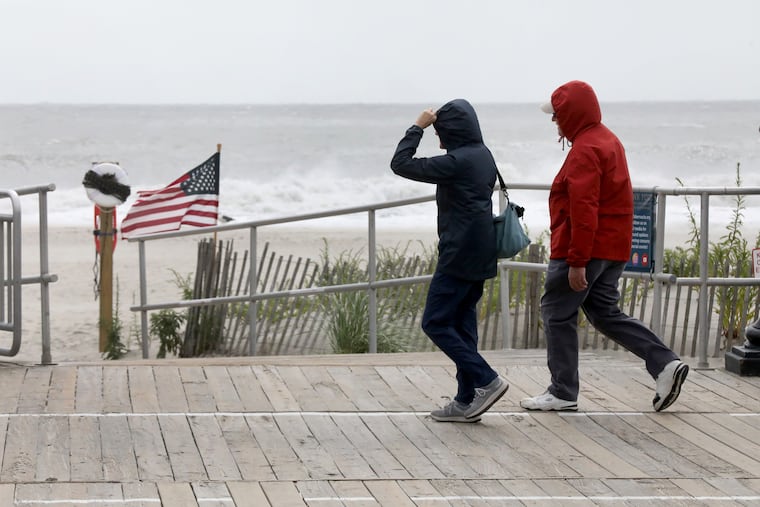
With moderate flooding already reported along with wind gusts to 50 mph at the Jersey Shore, forecasters were warning Thursday that the effects of an extraordinary early-season nor’easter were likely to intensify and may have some staying power.
“It could be slow to pull out,” said Lee Robertson, a lead meteorologist at the National Weather Service in Mount Holly. “We really may not be out of the woods until Monday.”
Updated computer-model runs were favoring a storm track closer to the coast than previously anticipated, said Bill Deger, senior meteorologist at AccuWeather Inc., which would increase both the flooding and wind potential. Beaches already have endured a long-duration assault of onshore winds, he added.
“Our beach is going to suffer,” Atlantic City Mayor Marty Small Sr. said at a Thursday afternoon briefing. “We’re going to see a lot of beach erosion.”
The more-westward track also would increase the potential for weekend rainfall throughout the region during a time typically busy for hayrides, corn mazes, and other autumn activities, Deger said. “Mother nature looks like it isn’t going to cooperative very much,” he said.
He said the nor’easter could even become a “bomb cyclone,” a term for an especially intense storm.
Potentially road-closing moderate flooding was forecast for the Jersey Shore Friday into Saturday. If the storm tracks further west, some places could see “major flooding,” said the weather service’s Robertson.
A flood warning was in effect for the Jersey Shore towns until 2 a.m. Saturday, and flood advisories along the Delaware River until 4 a.m. Friday.
Chances were excellent both would be extended. The storm, which was gaining strength off the Southeast coast Wednesday afternoon, could take its good old time as it travels northward, which would increase the duration of flooding and the strongest winds.
In addition, a high-wind watch was in effect at the Shore from 6 p.m. Friday into Saturday afternoon, with gusts that could reach 60 mph.
The expected timing of the storm impacts at the Shore and in Philly
Very much subject to change, the weather service outlook was for minor flooding on the oceanfront early Thursday evening and around daybreak Friday, with moderate flooding around high tides Friday at 7 p.m. and Saturday at 8 p.m.
At those levels, some roads become impassable, and building damage is possible.
In Philly, minor flooding was forecast along the Delaware River for at least the next five high-tide cycles, which occur roughly every 12 hours, starting at 1 a.m. Friday.
Warning that what was anticipated was more than “nuisance flooding,” Small said the critical periods in Atlantic City would be Friday from 6 a.m. to 10 a.m. and 6:30 p.m. to 10:30 p.m., and Saturday from 7 a.m. to 11 a.m. and 7:30 p.m. to 11:30 p.m.
He said he expected the streets to fill with up to a foot of water.
Scott Adams, the city’s emergency chief, said the duration of the winds and waves were prime concerns. “It’s not a one-two punch,” he said.
Just how much rain the storm would generate in the region was uncertain. The rains likely would reach the Shore late Friday and the immediate Philly area sometime Saturday afternoon, Deger said.
The winds were likely to peak to Friday afternoon into the evening; however, that would depend on the career of the storm.
The beaches should get a break Saturday as the winds become more northerly than onshore, Deger said, which would at least slow the erosion, but the strong winds likely would continue.
Isn’t this early for a nor’easter?
Coastal storms of this magnitude typically occur later in the fall and winter, as colder air from the north country interacts with the warm waters of the Gulf Stream. Storms form on frontal boundaries of warm and cold air.
In this case, a major player is an area of higher pressure, or heavier air, centered over eastern Canada, that has been exporting cold air southward. That has kept temperatures several degrees below normal in Philly this week.
It is working in tandem with the storm, providing the necessary cold air over to contrast with the warm waters. In addition, winds circulate clockwise around centers of low pressure, so it also was generating winds from the northeast, which is why they are called nor’easters.
Meanwhile, the intensifying storm also was generating winds from the northeast; winds circulate counterclockwise around centers of cyclones.
The high may be as impressive as the storm, said Steve Decker, atmospheric science professor at Rutgers University. In data dating to 1979, it might be the strongest high over Quebec on record.
He noted that while a nor’easter did develop in mid-September last year, “it was quite weak.” All indications are that this one won’t be.
Incidentally, this was to be the last weekend of open swimming in Atlantic City, but if you’re were hoping to take a dip, better wait until Memorial Day.
Small announced the beach would be closed, and all the equipment has been moved out of harm’s way.
Besides, the water might be a little rough.