Texas sees extreme flooding as more than a foot of rain falls in areas
The storm, now a tropical depression, has dumped an estimated 15 to 22 inches of rain in spots, and some areas could experience rain totals of 25 to 30 inches.
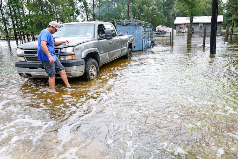
HOUSTON — An extreme flood scenario was underway Wednesday in Southeast Texas with the remnants of Edouard.
The storm, now a tropical depression, has dumped an estimated 15 to 22 inches of rain in spots, and some areas could experience rain totals of 25 to 30 inches.
A flash flood emergency was issued for Hardin and Tyler counties until 10:45 a.m. local time. By noon local time, a weather station near Saratoga, Texas, was up to 17.75 inches — 5.91 inches of which fell between 5 and 6 a.m. A station south of Ivanhoe, Texas, near Warren, has recorded 15.68 inches of rain. Another near Wildwood is up to 16.52 inches. And considerably more has probably fallen in the rural areas away from weather stations.
At least one person had to be evacuated in the East Texas town of Kountze after water entered a structure as heavy rain swept the area, according to staff at the National Weather Service office in Lake Charles, Louisiana.
Forecasters urged people to get to higher ground as rain continued to fall early Wednesday, delaying damage assessments.
“Move to higher ground now!” wrote the National Weather Service in Lake Charles. “This is an extremely dangerous and life-threatening situation. Do not attempt to travel unless you are fleeing an area subject to flooding or under an evacuation order.”
Texas deployed rescue aircraft, boats and high-water vehicles, and the state’s emergency operations center has been activated, along with 1,500 state personnel.
“We are getting it pretty good over here,” Kountze Mayor Glenn Matthews said by phone from his home, which has been without power since Tuesday night, noting crews were out doing welfare checks for the roughly 2,000 residents.
Matthews said he had not heard any reports of injuries or deaths related to the storm, and there were no evacuation orders for the area. But there was concern about elderly residents like his parents who were without power and sometimes need oxygen.
“What we’re doing now is making sure everyone is okay. Then we can try to assess the damage after the rain has let up some,” Matthews said. “It’s still raining as we speak. The city is pretty much flooded because this much rain at one time, there’s nothing the drainage can do about it. But it dissipates pretty well when it stops. This is not our first rodeo: We’ve been through this before many times.”
He noted that the rains came after a lengthy dry spell: “We had just declared a burn ban. Be careful what you ask for.”
At least 80,000 people were without power Wednesday morning across hard-hit areas of East Texas, the majority - about 50,000 — in coastal Port Arthur, an industrial refinery town of about 56,000.
“We’re out doing damage assessments this morning in between wind and rain bands. It’s still an organized storm, albeit moving to our north. The winds are stronger than what had been forecast,” said Jeff Branick, chief executive for Jefferson County surrounding Port Arthur.
Branick said the areas has “mostly debris issues, very little flooding” compared with Kountze and other areas to the north, where the state’s emergency management division has sent search-and-rescue boat teams.
But he noted that the area has “some industrial upsets because of the loss of power,” including widespread complaints overnight of gas and burning rubber odors near refineries.
“The investigation is still ongoing. Fortunately, after the odor appeared they determined one of their flares that’s used to offset the loss of power had not ignited and they got it ignited and the issue went away,” Branick said of a Valero refinery.
Downtown Houston has seen only about a tenth of an inch of rain, if that. The edge of the heaviest rain is razor-sharp, with a flood disaster 50 to 75 miles away.
Rainfall totals of 5 to 6 inches per hour are common in the heaviest bands. A staggering 5.91 inches fell in a single hour along Highway 787 west of Lumberton, Texas.
Edouard is a waterlogged system, making for extremely efficient precipitation processes. Not only is there more water in the atmosphere to work with, but the saturated atmosphere means there’s little to no evaporation of the raindrops on the way down.
There are even some indications that Edouard intensified a bit overnight. That’s because of several factors.
For starters, diurnal — day/night — processes often lead to enhanced convection, or thunderstorm, activity after nightfall. That sometimes allows tropical cyclones to strengthen a bit after dark, even if they’re moving inland.
The system also has an umbilical cord of moisture and instability, or thunderstorm fuel, feeding it from the southeast. That Gulf of Mexico connection helped fuel the storm, even far inland.
But the tiny core has remained remarkably intact. It’s not often a well-defined eye is present 115 miles inland. Edouard’s decay may also be slowed by something called the “brown ocean effect,” a rare phenomenon in which a tropical system that has made landfall behaves as if it’s over water.
It occurs when hot, saturated soils mimic a tropical ocean, allowing a cyclone to extract heat energy.
That may seem surprising considering there’s a drought in Texas. But the hot, sunbaked soils may have become a bit warmer due to the drought. Then they were resaturated by the initial rains from Edouard’s outer bands. Soil temperatures in the top 6 inches of ground in Southeast Texas were between 82 and 85 degrees as Edouard made landfall.
Marshall Shepherd, a researcher at the University of Georgia and a specialist on this process, likened it to a “flash brown ocean feedback.” In an email, he suggested the initial dry environment may have played a role.
Something similar happened with the remnants of Tropical Storm Erin, which came back to life over Oklahoma on Aug. 18, 2007. Research from 2021 noted that dry conditions preceded Erin but that the storm re-wet the hot soils, allowing the brown ocean effect to occur.
In the case of Edouard, the storm’s small size made it extra prone to interacting with the landscape, noted Brad Johnson, a research meteorologist and specialist on the role of land type.
In the interim, Edouard will continue to dump prolific moisture.
Steering currents are very weak, so there’s not much to scoot the system along. The storm was moving northwest at 5 mph — a brisk walking pace.
An additional 6 to 14 inches of rain may still fall in some spots.